Maharashtra Earthquake Swarms and Intraplate Seismicity Dynamics
Source:The Hindu ↗
ఇది ఎందుకు ముఖ్యం
Provides a concrete geomorphological example of intraplate seismicity and hydro-seismicity, crucial for answering geography questions about the structural stability of the Peninsular Block and assessing localized disaster vulnerability.
సారాంశం
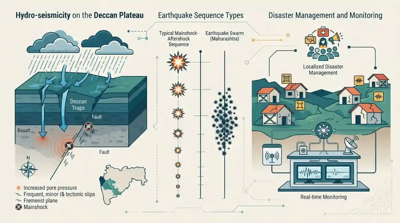
The article unpacks the phenomenon of 'earthquake swarms' in parts of Maharashtra (such as Palghar, Hingoli, and Nanded), which challenges the traditional assumption that the Deccan Plateau is a completely stable landmass. Unlike typical earthquake sequences that have a clear mainshock followed by aftershocks, swarms consist of continuous, low-magnitude tremors. In Maharashtra, this intraplate seismicity is primarily driven by hydro-seismicity—where percolating rainwater alters pore pressure in deep-seated geological faults and lineaments, causing minor but frequent tectonic slips. The persistent tremors highlight the importance of localized disaster management, structural vulnerability mapping, and real-time monitoring by the National Center for Seismology.
ముఖ్య అంశాలు
- An earthquake swarm is a sequence of mostly low-magnitude seismic events in a localized area, occurring over days or months, without a discernible 'mainshock.'
- While the Himalayas experience interplate earthquakes due to tectonic collision, the Deccan Plateau experiences 'intraplate seismicity' caused by ancient, deep-seated faults and lineaments beneath the basaltic rock.
- The swarms in Maharashtra are largely attributed to hydro-seismicity, where heavy monsoon rainwater percolates into underground fissures, increasing pore pressure, reducing fault friction, and triggering small repetitive slips.
- Though micro-earthquakes generally do not cause major destruction, sustained swarms induce panic, weaken poorly constructed structures, and underscore the need to continuously update India's seismic vulnerability assessments.
ముఖ్యమైన పదాలు
Earthquake Swarm

A sequence of continuous, low-magnitude seismic events clustered closely in time and space, lacking a distinct, single mainshock.
UPSC context
GS Paper I: Physical Geography. Tests understanding of non-traditional seismic sequences and localized tectonic stress release.
Hydro-seismicity
Seismic activity triggered by fluid migration or water percolation (e.g., rainfall or reservoir filling) that increases pore pressure along deep geological faults.
UPSC context
GS Paper I: Physical Geography. Tests knowledge of secondary triggers of tectonic slippage and reservoir-induced seismicity.
National Center for Seismology (NCS)
The nodal agency of the Indian Government under the Ministry of Earth Sciences, responsible for real-time, 24/7 monitoring of earthquake activity nationwide.
UPSC context
GS Paper III: Disaster Management. Tests institutional awareness of seismic monitoring networks and disaster early warning systems.
Seismic Zonation Map of India
A hazard classification map prepared by the Bureau of Indian Standards (BIS) dividing India into seismic zones based on historical intensity and vulnerability.
UPSC context
GS Paper III: Disaster Management. Tests risk vulnerability mapping, building codes, and mitigation preparedness.
Intraplate Seismicity
Earthquake activity occurring within the interior of a tectonic plate, far from active plate boundaries, typically caused by the reactivation of ancient faults.
UPSC context
GS Paper I: Physical Geography. Tests understanding of non-boundary crustal dynamics and stable shield seismicity.
ప్రిలిమ్స్ ఉచ్చు
"Earthquake swarms consist of a major mainshock followed by weeks of continuous low-magnitude aftershocks."
Swarms explicitly lack a single, discernible mainshock. They are a continuous sequence of relatively equal, low-magnitude events over a localized area.
అనుసంధానమైన స్థిర భావనలు
What is 'Intraplate Seismicity' and why does it occur in the Deccan Plateau?
- Definition: Earthquakes occurring within the interior of a tectonic plate, far from its active boundaries.
- Geological Drivers: Driven by the reactivation of ancient, deep-seated Precambrian faults and paleo-rifts hidden beneath the basaltic rock.
- Hydro-seismicity: Surface water (like heavy monsoon rains) percolates into deep fractures, increasing subterranean pore pressure, reducing fault friction, and triggering slips.
How is India classified into Seismic Zones?
- BIS Framework: The Bureau of Indian Standards (BIS) divides India into four active seismic zones ranging from Zone II to Zone V.
- Abolition of Zone I: Zone I was merged into Zone II in 2002 following the 1993 Latur earthquake, officially acknowledging that no region in India is entirely earthquake-immune.
- Peninsular Zonation: Most of the Deccan Plateau falls under Low (II) to Moderate (III) risk, but specific localized fault zones are rated higher.
అంతర-అంశ నమూనాలు
Reservoir-Triggered Seismicity (RTS)
Links natural hydro-seismicity (monsoon rainwater) to human-induced Reservoir-Triggered Seismicity (RTS), as seen historically at the Koyna Dam altering localized crustal stress.
Myth of the Stable Peninsular Shield
Overturns the geographical assumption that Peninsular India is a completely stable, aseismic shield block, emphasizing the role of ancient, reactivated faults.

Expect a multi-statement question contrasting 'earthquake swarms' (no mainshock) with typical tectonic sequences, paired with seismic zones.
అనుసంధాన PYQలు · 4
అనుసంధాన PYQలు · 4
- 2021MainsGS3
Discuss about the vulnerability of India to earthquake related hazards. Give examples including the salient features of major disasters caused by earthquakes in different parts of India during the last three decades.
- 2019MainsGS3
Vulnerability is an essential element for defining disaster impacts and its threat to people. How and in what ways can vulnerability to disasters be characterized? Discuss different types of vulnerability with reference to disasters.
- 2025MainsGS1
Discuss how the changes in shape and sizes of continents and ocean basins of the planet take place due to tectonic movements of the crustal masses.
- 2026PrelimsGS1
Which of the following geographical features or phenomena is/are associated with the Peninsular Block of India ? 1. Submergence of parts of the western coast due to tectonic activity 2. Presence of residual mountain ranges such as the Veliconda hills and Mahendragiri hills 3. Deep, V-shaped river valleys formed by fast-flowing rivers Select the answer using the code given below :
