Drainage issues cause waterlogging in Ahmedabad areas
Source:timesofindia ↗
Why It Matters
Highlights the critical challenges of urban planning and disaster management in rapidly expanding cities, emphasizing the necessity of preserving natural drainage geographies to prevent urban flooding.
Summary
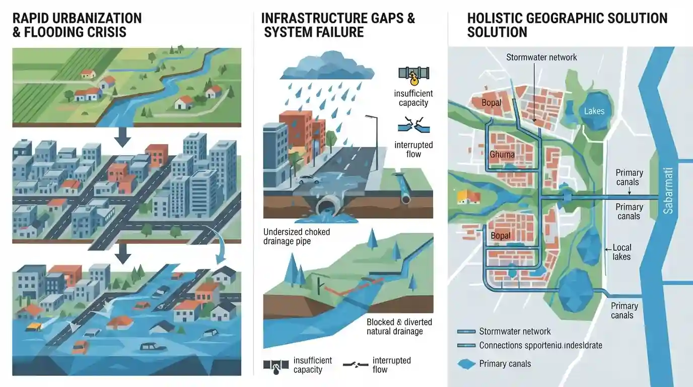
The article examines the recurring waterlogging and urban flooding issues in the fast-growing Bopal and Ghuma areas of Ahmedabad. Despite being incorporated into the Ahmedabad Municipal Corporation (AMC) and transitioning into key residential hubs, urbanization has outpaced the development of essential stormwater drainage infrastructure. The lack of a comprehensive drainage geography approach, the interruption of natural watercourses like the Gota-Godhavi canal, and insufficient stormwater network capacities are contributing to the crisis. Experts stress the need to view the drainage system holistically, extending to the Sabarmati river and connecting local lakes, to mitigate flooding.
Key Points
- Bopal and Ghuma, despite rapid urbanization and integration into the AMC, face severe recurring waterlogging and urban flooding.
- The crisis is primarily caused by urbanization drastically outpacing the development and expansion of essential stormwater drainage infrastructure.
- Natural watercourses, including the Gota-Godhavi canal and local lakes, have been interrupted or encroached upon, restricting the natural flow of stormwater.
- Experts recommend a holistic approach to drainage geography that extends beyond localized limits and connects comprehensive drainage networks directly to the Sabarmati river.
- The AMC is currently designing a master plan for the Ambli, Bopal, Ghuma, and Shela areas to establish an integrated stormwater network.
Important Terms
Ahmedabad Municipal Corporation (AMC)

The civic governing body responsible for administering Ahmedabad. It manages urban planning, infrastructure, and disaster response, including developing localized drainage master plans for newly incorporated areas like Bopal and Ghuma.
UPSC context
Crucial for GPSC Paper II and III, testing the role of urban local bodies in managing infrastructure and disaster mitigation.
Urban Flooding
The severe inundation of city areas caused by heavy rainfall overwhelming inadequate or outdated stormwater drainage systems, often exacerbated by rapid, unplanned urbanization and disrupted natural watercourses.
UPSC context
A core GS Paper III (Disaster Management) topic. GPSC assesses knowledge of its causes, structural mitigation, and impacts on developing cities.
Gota-Godhavi Canal
A vital regional water channel in western Ahmedabad. It serves as a key outfall destination for excess stormwater pumped out from flood-prone residential lakes and localities during monsoons.
UPSC context
Tests knowledge of Gujarat's local geography and water resource management, relevant for GS Paper I and III infrastructure planning.
Storm Water Drainage Master Plan
A comprehensive urban infrastructure blueprint that designs localized networks of drains, interconnections, and outfalls to systematically channel heavy surface runoff into natural water bodies or rivers.
UPSC context
Important for GS Paper III (Infrastructure). GPSC evaluates how proactive town planning accommodates rapid urban expansion and prevents civic crises.
Hydrological Survey
A scientific study mapping the distribution, movement, and behavior of surface water and groundwater in an area. It guides the engineering and structural capacity of urban drainage systems.
UPSC context
Relevant to GS Paper III (Disaster Management and Science). Shows the necessity of evidence-based policy in public administration.
Prelims Trap
"Urban flooding is officially classified solely as a natural hydro-meteorological disaster."
NDMA classifies urban flooding as a distinct, significantly man-made disaster driven by unchecked concretization, drainage encroachment, and poor urban planning, not just heavy rainfall.
Static Concepts Connected
What are the core NDMA guidelines for Urban Flooding management?
- Distinct Classification: Recognizes urban flooding as largely man-made and treats it as a disaster distinct from traditional riverine flooding.
- Drainage Master Plans: Mandates updating comprehensive drainage master plans, removing encroachments on natural water bodies, and ensuring pre-monsoon desilting.
- Localized EWS: Advocates for the establishment of localized, high-resolution Early Warning Systems (EWS) tailored to specific urban catchments.
How did the Harappan site of Dholavira manage stormwater?
- Advanced Water Harvesting: Engineered a highly sophisticated system of stone-cut reservoirs, check dams, and drains to harvest rainwater in a semi-arid region.
- Topographical Alignment: The city's natural slope was meticulously mapped and utilized to channel excess stormwater into interconnected reservoirs without flooding residential areas.
Cross-Topic Patterns
Dholavira vs. Modern Urbanization
Exam questions often contrast the sustainable, topography-aligned stormwater drainage of Harappan Dholavira with the haphazard concretization and encroachment causing urban floods in modern Gujarat cities.
NITI Aayog's G-HUB + AMRUT
NITI Aayog's Growth Hub (G-HUB) programme promotes economic expansion in city-regions, directly testing the capacity of schemes like AMRUT to sustainably manage peripheral drainage and wetlands.

Expect a GS-3 or Prelims question pairing NDMA urban flooding guidelines with Dholavira's ancient water harvesting techniques.
Linked PYQs · 3
Linked PYQs · 3
- 2025GPSC_PRELIMSGS1
Which of the following statements is/are correct? 1. The Indus Valley Civilization was the first urbanization in India. 2. It had a well-planned drainage system and grid-pattern town planning. 3. The society followed a strict hierarchical structure with social inequalities. 4. Agriculture was the primary economic activity with trade and commerce flourishing.
- 2026GPSC_PRELIMSGS1
Consider the following statements regarding Aravallis: 1. The region is home to important lakes and wetlands including Sambhar, Sultanpur, Pushkar, Fatehsagar and Jaisamand. 2. It is one of the main watersheds, separating the drainage of the Bay of Bengal, through rivers like Chambal and other tributaries of the Yamuna, from that of the Arabian Sea through the Mahi, Sabarmati, Luni and other rivers. 3. The mountain range is home to lead, zinc, copper, gold, tungsten and has reserves of critical minerals such as tin, graphite, molybdenum, niobium, nickel, lithium and rare earth elements (REEs). These are considered to be of strategic relevance for energy transition, high-technology manufacturing and national security. 4. Rocks in the Aravallis are highly fractured, weathered and porous, allowing rainwater to percolate deep into the ground instead of running off the surface. Any disruption to this recharge system, through mining, construction or deforestation poses a direct and serious threat to regional water availability. 5. The Aravalli hills and range are 'green lungs' of North-Western India and serve as the indispensable ecological and socio-economic backbone of the region, functioning as the primary geographical barrier separating the arid North-Western desert from the fertile Northern Indian plains. Which of the above statements are correct?
- 2019GPSC_PRELIMSGS1
Which of the following statements are correct regarding excavated sites in Gujarat? Site On the River/Or Esle 1. Lothal Saraswati 2. Rojadi Bhadar 3. Dholavira In the Desert of Kutch 4. Malvan Tapi
