IMD Forecasts Heavy Rainfall Across Gujarat Regions
Source:desh-gujarat ↗
Why It Matters
The spatial distribution of rainfall in Gujarat and the functioning of the IMD's weather alert systems are essential concepts for the GPSC Prelims Geography syllabus. Questions frequently test candidates' knowledge of regional climatic zones (e.g., Kutch vs. South Gujarat) and the impacts of the Southwest Monsoon.
Summary
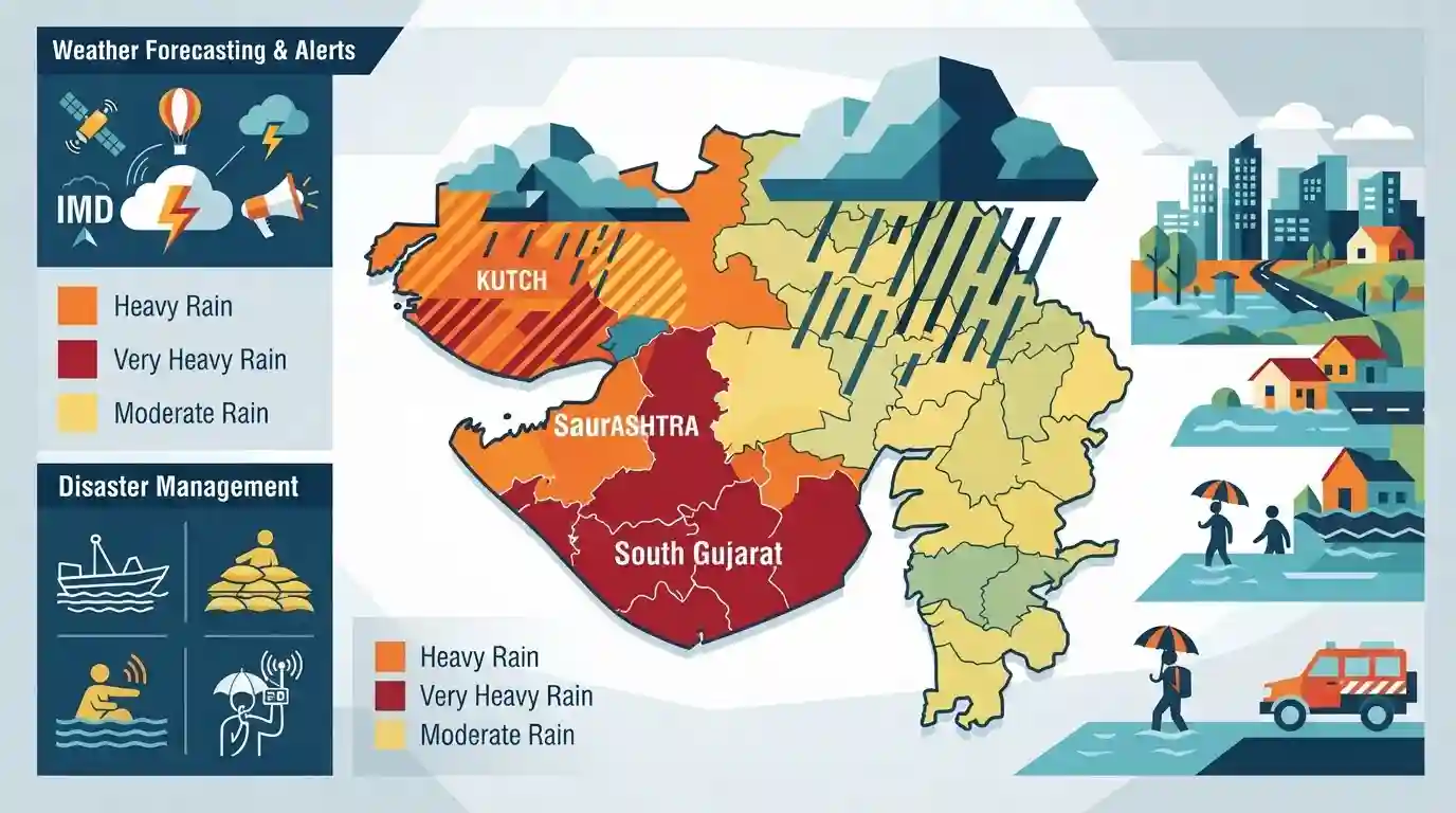
The Indian Meteorological Department (IMD) has issued detailed heavy rainfall forecasts and color-coded alerts for various districts across Gujarat for the upcoming week. The active monsoon system is expected to bring significant precipitation, particularly to the regions of Saurashtra, Kutch, and South Gujarat. Authorities have warned of potential localized flooding and advised residents to remain cautious.
Key Points
- The Indian Meteorological Department (IMD) has issued heavy rainfall forecasts for multiple districts in Gujarat for the upcoming week.
- Different regions, including Saurashtra, Kutch, and South Gujarat, have been placed under specific color-coded alerts (Yellow/Orange) based on the expected intensity of the precipitation.
- The active monsoon conditions heighten the risk of localized flooding and waterlogging in vulnerable areas.
- Citizens and local administrations are advised to take necessary precautions to mitigate the impact of the heavy downpours.
Important Terms
India Meteorological Department (IMD)

The principal government agency responsible for meteorological observations and weather forecasting in India. It issues critical early warnings and color-coded alerts to mitigate the impact of severe weather events like floods and cyclones.
UPSC context
GS-3 Disaster Management. Tests knowledge of institutional frameworks for disaster preparedness and early warning systems in India.
Color-Coded Weather Warnings
An IMD alert system categorizing weather severity: Green (no threat), Yellow (be aware), Orange (be prepared), and Red (take action). It provides actionable guidance to authorities and the public during disasters.
UPSC context
GS-3 Disaster Management. Evaluates awareness of risk communication protocols, administrative response, and disaster mitigation strategies.
Saurashtra and Kutch
A predominantly semi-arid peninsular region in western Gujarat. Though typically characterized by dry climates and water scarcity, it is increasingly vulnerable to extreme, localized flooding during intense, active monsoon periods.
UPSC context
GS-1 Geography. Tests knowledge of India's regional physical geography, climate variability, and shifting weather extremes.
Active Monsoon System
A phase of the Indian summer monsoon characterized by strong low-level moisture convergence and sustained heavy rainfall over specific regions. It is crucial for water resources but can trigger destructive flooding.
UPSC context
GS-1 Physical Geography. Vital for understanding the mechanics of the Indian monsoon, rainfall variability, and their socio-economic impacts.
Prelims Trap
The Arabian Sea branch of the monsoon bypasses Gujarat entirely because the Aravalli range lies parallel to the rain-bearing winds.
The Aravallis run parallel to the Rajasthan branch, but the Saurashtra-Kutch sub-branch strikes Gujarat directly. Low-pressure systems and depressions regularly cause intense precipitation in Saurashtra and South Gujarat.
Static Concepts Connected
What are the four pillars of an Early Warning System (EWS) under the Sendai Framework?
- Disaster Risk Knowledge: Systematically collecting data and assessing hazards, vulnerabilities, and exposure levels.
- Detection & Forecasting: Constantly monitoring hazards like extreme rainfall to provide accurate, timely forecasts.
- Warning Dissemination: Communicating clear, actionable warnings through reliable channels to reach the last mile.
- Preparedness & Response: Educating communities and keeping local administrations ready to act instantly on warnings.
How does the Arabian Sea branch of the Southwest Monsoon behave over Gujarat?
- Three-way Split: Splits into three branches: Western Ghats, Narmada-Tapi trough, and Saurashtra-Kutch.
- Saurashtra-Kutch Branch: This sub-branch strikes the Gujarat peninsula, providing essential rain before moving inland.
- Aravalli Alignment: While Gujarat receives rain, Rajasthan gets bypassed because the Aravallis lie parallel to these winds.
Cross-Topic Patterns
Sponge Cities + Monsoon Extremes
Extreme rainfall over semi-arid zones like Kutch stresses urban drainage. Integrating sponge city concepts into urban planning is crucial for coastal Gujarat's industrial hubs.
Sendai Priority 4 + Panchayat Readiness
Translating IMD's color alerts into localized action tests village-level disaster management committees, directly mapping to India's commitments under Sendai Framework's Priority 4.

Monsoon branch dynamics and IMD color-coded alert definitions are highly likely to be paired in a multi-statement physical geography question.
Linked PYQs · 2
Linked PYQs · 2
- 2026GPSC_PRELIMSGS1
Consider the following statements regarding climate change: 1. Floods and droughts are increasing in India. 2. There has been a sharp increase in the number of tropical cyclones in India. 3. Humidity levels are gradually increasing in the regions of central India. Which of the above statement/s is/are correct?
- 2026GPSC_PRELIMSGS1
Consider the following statements regarding the drainage system of Kutch: 1. Most rivers in the Kutch region are ephemeral and non-perennial, carrying water only during the brief monsoon season. 2. The rivers originating from the central hilly tracts of Kutch invariably drain into the Arabian Sea directly. 3. The Luni River, after traversing through Rajasthan, dissipates into the marshy lands of the Rann of Kutch. Which of the above statements are correct?
