Cartographic Distortion and Representation of Africa on Maps
Source:The Hindu ↗
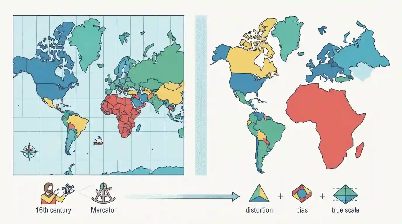
Why It Matters
Understanding map projections and spatial distortion is a fundamental concept in physical and human geography (GS1), helping aspirants critically analyze cartographic representations, historical Eurocentric biases, and the actual geopolitical proportions of the Global South.
Summary
The article explains how traditional world maps, particularly the widely used Mercator projection, severely distort the true size and proportions of continents, most notably shrinking Africa relative to North America and Europe. Designed in 1569 for nautical navigation, the Mercator projection distorts landmasses by expanding areas further away from the equator. As a result, Africa—the world's second-largest continent—is visually minimized compared to places like Greenland or Europe, highlighting issues of cartographic bias and Eurocentrism in geography.
Key Points
- The Mercator projection, created by Gerardus Mercator in 1569 for navigation, severely distorts the size of landmasses as they get closer to the poles while shrinking landmasses near the equator.
- Africa, despite being the second-largest continent in the world by land area (about 30.3 million sq km), often appears on standard world maps to be roughly the same size as Greenland or smaller than North America due to this cartographic distortion.
- Greenland (approx. 2.16 million sq km) appears disproportionately massive on Mercator maps, sometimes looking comparable to or larger than all of Africa.
- Cartographic bias has historical implications, reflecting Eurocentric worldviews that marginalized the Global South in geopolitical and geographical representations.
Important Terms
Mercator Projection

A cylindrical map projection created in 1569 that preserves local angles and directions for navigation, but severely distorts landmass sizes by enlarging regions farther away from the equator.
UPSC context
UPSC Prelims/Mains - Geography (World Physical Geography, Cartography, Map Projections). Tests understanding of map distortion and geographical representations.
True Size of Africa
The actual geographic scale of the African continent, which is roughly 14 times larger than Greenland, despite appearing deceptively similar in size on traditional Mercator world maps.
UPSC context
UPSC Prelims/Mains - World Geography and International Relations. Highlights spatial bias, map distortions, and the geopolitical representation of the Global South.
Static Concepts Connected
What are the fundamental trade-offs and properties of common world map projections?
- Mercator Projection: A cylindrical conformal map designed for marine navigation by preserving angles, but severely distorts landmass sizes, enlarging regions far from the equator.
- Gall-Peters Projection: A cylindrical equal-area projection that corrects size distortions of the Global South, though it stretches and distorts shapes horizontally near the poles.
- Equal Earth Projection: A modern pseudocylindrical compromise projection created in 2018 to balance the visual representation of continents and oceans without extreme distortion.
Cross-Topic Patterns
Cartography, Colonialism, and the Global South
Cartography is rarely neutral; historical maps reflect colonial geopolitics and Eurocentric worldviews that continue to shape global mental models and international relations discourse.

Expect a statement-based prelims question on map projections (Mercator vs Equal Area) testing area distortions and nautical vs spatial utility.
Linked PYQs · 1
Linked PYQs · 1
- 2025PrelimsGS1
Which of the following are the evidences of the phenomenon of continental drift? I. The belt of ancient rocks from Brazil coast matches with those from Western Africa. II. The gold deposits of Ghana are derived from the Brazil plateau when the two continents lay side by side. III. The Gondwana system of sediments from India is known to have its counterparts in six different landmasses of the Southern Hemisphere. Select the correct answer using the code given below.
