Belwa Minapur Link Channel for Flood Mitigation in North Bihar
Source:The Hindu ↗
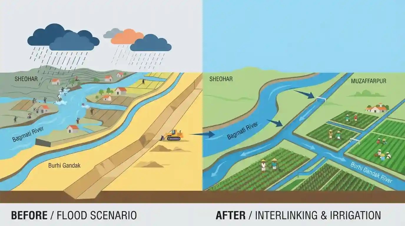
Why It Matters
North Bihar faces severe, recurrent flooding, largely due to Himalayan rivers like the Bagmati. The Belwa-Minapur link is a vital infrastructure intervention for BPSC candidates to understand, as it addresses both disaster management (flood mitigation) and agricultural economics (irrigation) through the interlinking of intra-state rivers.
Summary
The Belwa-Minapur Link Channel is an important river interlinking and flood mitigation project in Bihar. By linking the flood-prone Bagmati river at Belwa (Sheohar) with the Burhi Gandak river via Minapur (Muzaffarpur), the project diverts excess water during the monsoon. This infrastructure primarily aims to prevent the annual inundation of the Bagmati basin while simultaneously enhancing irrigation capacity in the water-scarce agricultural regions of Muzaffarpur, marking a significant step in North Bihar's disaster management and water resource optimization.
Key Points
- The Belwa-Minapur Link Channel is a crucial river interlinking project in Bihar designed to connect the Bagmati river with the Burhi Gandak river.
- The project involves constructing a head regulator at Belwa in Sheohar district to divert excess floodwaters from the Bagmati river.
- Diverted water flows through the channel to Minapur in Muzaffarpur district, ultimately joining the Burhi Gandak, reducing the flood burden in the Bagmati basin.
- The channel serves a dual purpose: mitigating devastating floods in North Bihar districts like Sheohar and Sitamarhi, and providing reliable irrigation to Muzaffarpur and adjoining areas.
Important Terms
Belwa-Minapur Link Channel Project

A 68-kilometer-long canal project in Bihar that diverts monsoon overflow from the flood-prone Bagmati River to the Burhi Gandak River, mitigating floods and boosting regional agricultural irrigation.
UPSC context
GS Paper III (Disaster Management & Water Resources); tests state-level initiatives in flood mitigation and regional irrigation infrastructure.
Intra-state River Linking
Projects designed to connect and transfer surplus water between rivers flowing entirely within the boundaries of a single state, addressing localized water scarcity and flooding without triggering interstate disputes.
UPSC context
GS Paper I (Geography) & III (Infrastructure); tests understanding of localized water-resource management models and federal water governance.
National Perspective Plan
Formulated in 1980, this national water grid plan managed by the NWDA outlines the interbasin transfer of water from surplus Himalayan and Peninsular river basins to water-deficit regions.
UPSC context
GS Paper III (Infrastructure & Water Security); tests knowledge of central schemes for river interlinking and long-term water management.
Bagmati River
A rain and spring-fed transboundary river originating in Nepal's Shivapuri Hills that flows through northern Bihar, notorious for severe monsoon flooding before draining into the Burhi Gandak River.
UPSC context
GS Paper I (Indian Geography); tests knowledge of northern Himalayan tributaries, their transboundary courses, and seasonal flooding dynamics.
Burhi Gandak River
A 320-km-long tributary of the Ganges originating in West Champaran, Bihar, flowing parallel to the Gandak river, and notable for its meandering course that forms Kanwar Lake oxbow.
UPSC context
GS Paper I (Geography); tests awareness of major Ganga tributaries, their drainage basins, geomorphology, and associated wetlands.
Prelims Trap
Both the Bagmati and Burhi Gandak rivers originate in the Himalayan glaciers of Nepal before entering Bihar.
While major North Bihar rivers like the Bagmati, Gandak, and Koshi originate in Nepal, the Burhi Gandak is unique as it originates within India (Chautarwa Chaur in West Champaran, Bihar).
Static Concepts Connected
What are the geographical origins and drainage patterns of the Bagmati and Burhi Gandak rivers?
- Bagmati River Origin: Originates in the Shivapuri Range of the Himalayas in Nepal, flows past Kathmandu, and enters India in Bihar's Sitamarhi district.
- Burhi Gandak Origin: Originates within India at Chautarwa Chaur in the West Champaran district of Bihar.
- Confluence: The Burhi Gandak flows parallel to the Gandak river before joining the Ganga as a left-bank tributary near Khagaria.
How does India's River Interlinking framework distinguish between Inter-basin and Intra-state projects?
- NRLP Authority: Managed by the National Water Development Agency (NWDA) under the Ministry of Jal Shakti.
- Dual Components: Comprises the Peninsular Rivers Development Component and the Himalayan Rivers Development Component.
- Intra-State Links: Planned and executed within a single state to address regional water imbalances without interstate water-sharing disputes.
Cross-Topic Patterns
Siltation dynamics and wetland ecology
Diverting high-silt rivers like the Bagmati to control floods can alter downriver deltaic ecosystems, impacting soil fertility and wetland (Chaur) ecology in North Bihar.
Federal water governance and intra-state links
Intra-state river linking bypasses complex interstate water disputes, granting states autonomous control over water-resource allocation and disaster-response deployment.

Map-based matching questions pairing North Bihar's Himalayan vs. domestic-origin rivers and intra-state links are highly probable for 2026.
Linked PYQs · 2
Linked PYQs · 2
- 2020BPSC_PRELIMSGS1
Which of the following rivers flowing in Bihar is a north flowing river?
- 2023BPSC_PRELIMSGS1
The other name of river Gandak is
