IndiGo Flight Executes First GAGAN Landing at Udaipur Airport
Source:republic-world ↗
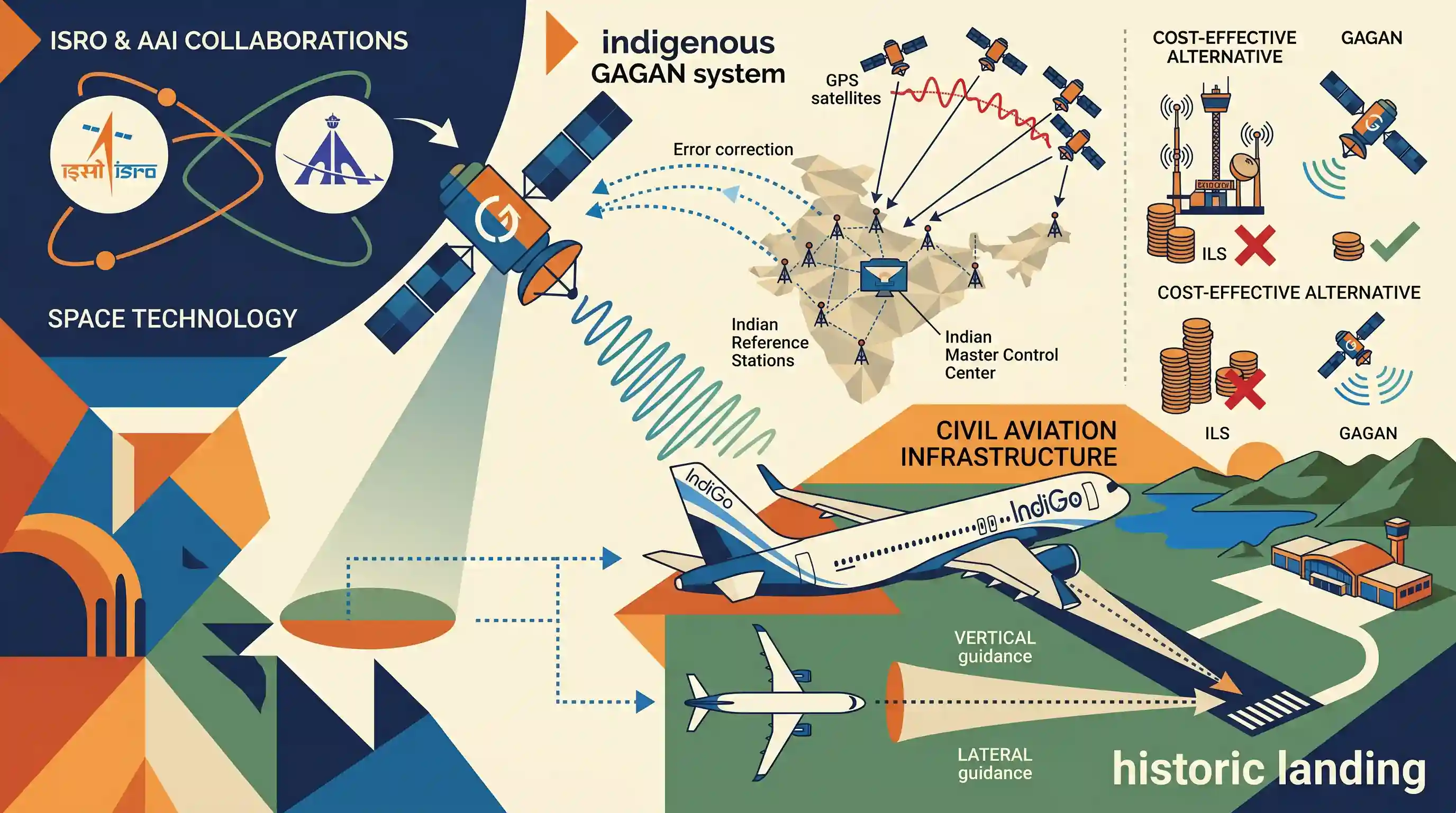
Why It Matters
This technological milestone marks India's transition to self-reliant, high-precision air navigation, dramatically boosting civil aviation safety, reducing flight operational costs, and transforming regional air connectivity at smaller airports—particularly relevant to Rajasthan's tourism and transit corridors.
Summary
An IndiGo flight successfully completed a historic landing at Udaipur's Maharana Pratap Airport using the indigenous GAGAN (GPS Aided GEO Augmented Navigation) system. Jointly developed by ISRO and AAI, GAGAN is a Satellite-Based Augmentation System (SBAS) that provides high-precision vertical and lateral landing guidance by correcting ionospheric errors in GPS signals, offering a cost-effective alternative to ground-based landing infrastructure at regional airports.
Key Points
- IndiGo became the first commercial airline in India to land an aircraft (Airbus A320) using the indigenous GAGAN navigation system at Udaipur's Maharana Pratap Airport under DGCA supervision.
- GAGAN is a Satellite-Based Augmentation System (SBAS) jointly developed by ISRO and AAI to enhance the accuracy of GPS receiver positioning over India.
- Rather than replacing GPS, GAGAN acts as a high-precision corrector, mitigating signal bends and delays caused by the Earth's ionosphere, particularly the Equatorial Ionisation Anomaly (EIA) over India.
- The architecture utilizes 15 Indian Reference Stations (INRES) on the ground to register GPS errors, sending data to the Indian Master Control Centre (INMCC) which calculates corrections and beams them to GSAT-8 and GSAT-10 satellites over the equator.
- Provides Localiser Performance with Vertical Guidance (LPV) approaches, allowing aircraft to land safely in low-visibility, mountainous, or poorly equipped runways without costly ground-based Instrument Landing Systems (ILS).
- Enables fuel conservation, reduces flight cancellations, lowers operational carbon footprints, and boosts regional aviation connectivity across Tier-2 and Tier-3 cities in India.
Important Terms
GAGAN (GPS Aided GEO Augmented Navigation)

India's indigenous Satellite-Based Augmentation System (SBAS) developed by ISRO and AAI. It corrects GPS signal errors to provide highly accurate, reliable navigation, primarily for civil aviation and disaster management.
UPSC context
GS Paper 3: Science and Technology (space technology, indigenous systems, and civil aviation safety).
Indian Space Research Organisation (ISRO)
The primary space agency of India, established in 1969 under the Department of Space. It designs and launches satellites, launch vehicles, and space exploration missions for national and scientific development.
UPSC context
GS Paper 3: Science and Technology (indigenous developments, satellite systems, and space exploration achievements).
Airports Authority of India (AAI)
A statutory body under the Ministry of Civil Aviation established in 1995. It is responsible for creating, upgrading, maintaining, and managing civil aviation infrastructure and providing air traffic management services in India.
UPSC context
GS Paper 3: Infrastructure (airports, connectivity, and institutional frameworks managing civil aviation).
Directorate General of Civil Aviation (DGCA)
The statutory regulatory body under India's Ministry of Civil Aviation. It acts as the apex civil aviation authority responsible for safety oversight, licensing, airworthiness standards, and implementing flight safety rules across Indian airspace.
UPSC context
GS Paper 2 & 3: Regulatory bodies, transport infrastructure, safety standards, and governance.
Prelims Trap
GAGAN is India's independent, standalone satellite-navigation system designed to replace the US-owned Global Positioning System (GPS).
GAGAN is a Satellite-Based Augmentation System (SBAS) that modifies/corrects borrowed GPS signals. It is NOT a standalone, independent satellite constellation. NavIC (IRNSS) is India's independent navigation constellation.
Static Concepts Connected
What is the difference between a Standalone GNSS and a Satellite-Based Augmentation System (SBAS)?
- GNSS function: Global Navigation Satellite Systems (like GPS, GLONASS) provide direct positioning data using their own global constellation of satellites.
- SBAS operation: SBAS (like GAGAN, WAAS, EGNOS) does not replace GNSS; it uses ground stations to measure GNSS signal errors and broadcasts corrections via geostationary satellites.
- India's systems: NavIC is India's independent, standalone regional satellite navigation system, whereas GAGAN is India's GPS-dependent augmentation system.
What is the Equatorial Ionisation Anomaly (EIA) and its impact on space communication?
- EIA definition: It is a region of high electron density in the F-layer of the ionosphere, located around 15 degrees north and south of the magnetic equator.
- Signal degradation: The high concentration of free electrons causes severe delay, bending, and scintillation of satellite signals passing through the ionosphere.
- Mitigation by GAGAN: GAGAN uses the proprietary 'IGM-MLDF' algorithm to calculate real-time ionospheric corrections, making it the first SBAS certified to operate in equatorial anomaly regions.
Cross-Topic Patterns
Space tech + Civil Aviation modernising
Integrates space assets with the UDAN scheme to enable all-weather operations at low-cost, underserved regional airports without expensive ground-based Instrument Landing Systems (ILS).
Dual-use space tech in governance
High-accuracy positioning from GAGAN enhances precision farming, mapping of forest resources, railway unmanned level-crossing warning systems, and real-time emergency disaster tracking.

UPSC 2026 is highly likely to contrast GAGAN's SBAS role with NavIC's standalone regional network, focusing on ionospheric corrections.
Linked PYQs · 2
Linked PYQs · 2
- 2018RPSC_PRELIMSGS1
Consider the following pairs. ISRO Center – Location A. Vikram Sarabhai Space Centre (VSSC) (Kerala) B. U.R. Rao Satellite Centre Bangalore (UPSC) (Karnataka) C. National Remote Sensing Centre Dehradun (RSC) (Uttarakhand) D. Indian Institute of Remote Sensing Hyderabad (IIRS) (Telangana) Which of the above are correctly matched?
- 2016RPSC_PRELIMSGS1
Match the following: Launch Vehicle – Satellite A. Satellite Launch Vehicle-3 (SLV-3) – 1. Chandrayaan-1 B. Augmented Satellite Launch Vehicle (ASLV) – 2. Rohini C. Polar Satellite Launch Vehicle (PSLV) – 3. SRE-C D. Geosynchronous Satellite Launch Vehicle (GSLV) – 4. EduSat Code:
