Wayanad Landslides One Year On Rehabilitation Challenges
Source:Indian Express ↗
Why It Matters
The Wayanad landslides are a textbook case study for GS3 Disaster Management and GS1 Geography, frequently tested by UPSC. Understanding the human impact and recovery process is crucial for evaluating disaster response, hazard zonation, and the ecological vulnerability of the Western Ghats.
Summary
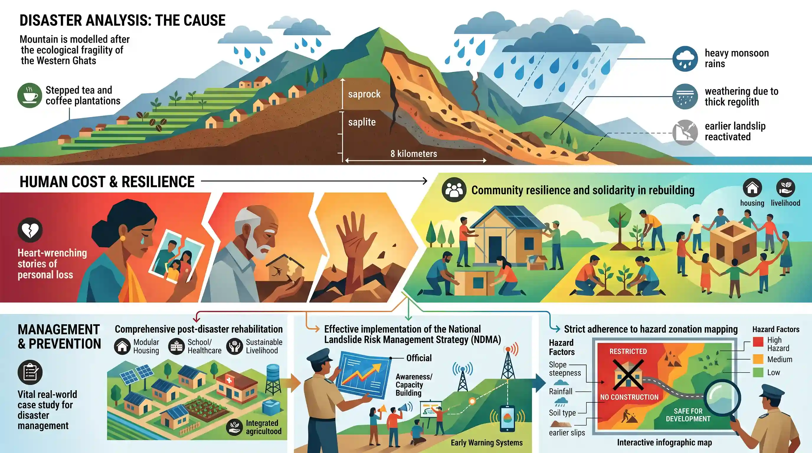
A year after the catastrophic landslides in Wayanad, Kerala, the affected communities continue to navigate the complex journey of recovery. The article documents heart-wrenching stories of personal loss juxtaposed with remarkable community resilience and solidarity in rebuilding their lives. For civil services aspirants, this situation provides a vital real-world case study on disaster management and the ecological fragility of the Western Ghats. It starkly highlights the real human costs of such natural disasters and underscores the urgent necessity for comprehensive post-disaster rehabilitation, effective implementation of the National Landslide Risk Management Strategy, and strict adherence to hazard zonation mapping to prevent future tragedies in geologically and ecologically sensitive regions.
Key Points
- The article reflects on the devastating Wayanad landslides, capturing both the profound loss of life and property and the enduring trauma of the survivors.
- It highlights the ongoing challenges in post-disaster rehabilitation, including rebuilding infrastructure, restoring livelihoods, and providing psychological support.
- The disaster underscores the vulnerability of the Western Ghats to extreme rainfall and landslides, raising questions about sustainable land use and ecological conservation in sensitive zones.
- From a policy perspective, it emphasizes the need for proactive disaster mitigation strategies, such as hazard zonation mapping and robust early warning systems, rather than purely reactive measures.
Important Terms
National Landslide Risk Management Strategy

A 2019 NDMA-led framework addressing hazard mapping, monitoring, early warning systems, and mountain zone regulations to reduce landslide vulnerability across approximately 12.6% of India's landmass.
UPSC context
GS Paper 3: Disaster Management; tests knowledge of specific policy frameworks for mitigating geohazards and enhancing regional resilience.
NDMA (National Disaster Management Authority)
India's apex statutory body for disaster management, chaired by the Prime Minister; it formulates national policies, plans, and guidelines to ensure effective disaster response and risk reduction.
UPSC context
GS Paper 2/3: Polity/DM; tests understanding of apex statutory bodies and India's institutional architecture for managing natural calamities.
State Disaster Management Authority (SDMA)
The state-level statutory body chaired by the Chief Minister, responsible for laying down state disaster policies and coordinating the implementation of the State Disaster Management Plan.
UPSC context
GS Paper 2/3: Polity/DM; tests knowledge of federal disaster management structures and the role of states in localized disaster response.
Landslide Hazard Zonation (LHZ) Mapping
A disaster mitigation tool that categorizes land into zones based on susceptibility to landslides, using factors like slope stability and soil type to guide safe land-use planning.
UPSC context
GS Paper 1/3: Geography/DM; tests technical awareness of risk-assessment tools and their application in sustainable infrastructure and regional development.
Gadgil Committee (WGEEP)
A 2011 expert panel report (WGEEP) that recommended designating the entire Western Ghats as an Ecologically Sensitive Area (ESA) and strictly restricting development in the most fragile zones.
UPSC context
GS Paper 3: Environment/Ecology; tests understanding of ecological preservation debates and the balance between development and environmental safety in fragile regions.
Landslide Atlas of India
A comprehensive document by ISRO's National Remote Sensing Centre mapping landslide-prone regions and documenting historical events to aid in disaster risk assessment across India.
UPSC context
GS Paper 1/3: Geography/DM; tests data-driven understanding of India's geographical vulnerability and the role of remote sensing in disaster planning.
Prelims Trap
Landslides in the Western Ghats are primarily driven by tectonic instability and active fault lines.
Unlike the Himalayas, which are tectonically active and young, the Western Ghats are geologically stable. Landslides here are predominantly driven by intense rainfall and anthropogenic factors like mining.
Static Concepts Connected
How did the Gadgil and Kasturirangan committees differ on Western Ghats conservation?
- Gadgil Committee (WGEEP): Recommended designating the entire Western Ghats region as an Ecologically Sensitive Area (ESA) with three strict tiers of regulation.
- Kasturirangan Committee: Diluted the previous report, recommending only about 37% of the total area be classified as ESA, allowing certain infrastructure projects while banning mining and thermal plants.
What are the core components of the National Landslide Risk Management Strategy (2019)?
- Hazard Zonation Mapping: Categorizing slopes based on vulnerability at macro and micro scales to strictly guide land-use planning.
- Early Warning Systems: Developing rainfall-threshold based predictive models to evacuate vulnerable communities before the event occurs.
- Mountain Regulations: Enforcing strict town planning rules, building codes, and restricting heavy construction on highly unstable mountain slopes.
Cross-Topic Patterns
Climate change & extreme rainfall triggers
Wayanad's tragedy highlights the collision between changing monsoon dynamics (extreme short-duration rainfall) and unscientific land-use, transforming it from a mere geological event to a climate-adaptation crisis.
Disaster funding & Cooperative Federalism
Post-disaster recovery in Kerala frequently triggers center-state debates on the financial autonomy of states, the role of SDMAs, and the criteria for NDRF/SDRF fund allocations.

Expect a Mains GS3 question linking Western Ghats ecology (Gadgil/Kasturirangan) directly to the rising frequency of monsoon landslides.
Linked PYQs · 5
Linked PYQs · 5
- 2021MainsGS3
Describe the various causes and the effects of landslides. Mention the important components of the National Landslide Risk Management Strategy.
- 2021MainsGS1
Differentiate the causes of landslides in the Himalayan region and Western Ghats.
- 2019MainsGS3
Disaster preparedness is the first step in any disaster management process. Explain how hazard zonation mapping will help disaster mitigation in the case of landslides.
- 2013MainsGS1
Bring out the causes for more frequent occurrence of landslides in the Himalayas than in the Western Ghats.
- 2020MainsGS3
Discuss the recent measures initiated in disaster management by the Government of India departing from the earlier reactive approach.
