Uttarakhand First Glacial Lake Early Warning System at Vasundhara Tal
Source:drishtiias ↗
Why It Matters
Important for state-specific disaster mitigation and geography questions concerning climate vulnerabilities and high-altitude water bodies in Uttarakhand.
Summary
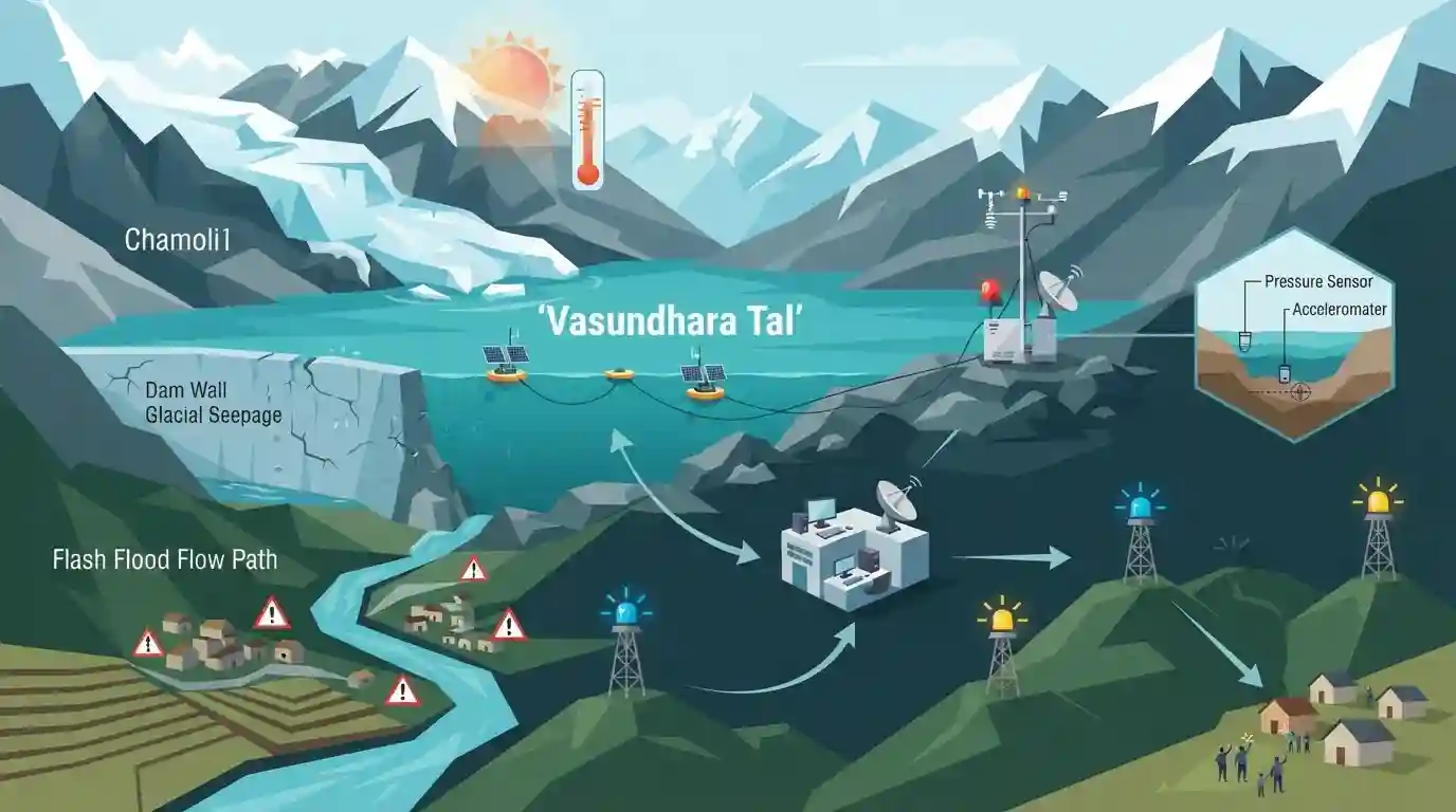
Uttarakhand has established its first Glacial Lake Early Warning System (GLEWS) at Vasundhara Tal in the Chamoli district to monitor and mitigate risks associated with Glacial Lake Outburst Floods (GLOFs). This critical technological intervention addresses climate change vulnerabilities in the Himalayan region.
Key Points
- Uttarakhand has installed its first Glacial Lake Early Warning System (GLEWS) at Vasundhara Tal in the Chamoli district.
- The system is designed to detect potential Glacial Lake Outburst Floods (GLOFs) and provide timely warnings to downstream areas.
- Vasundhara Tal is a vulnerable high-altitude glacial lake situated in the ecologically sensitive Himalayan region of Chamoli.
- The initiative aims to enhance disaster preparedness, mitigate risks from climate change-induced hazards, and protect human lives and infrastructure in mountain regions.
Important Terms
Glacial Lake Early Warning System (GLEWS)

A technological setup utilizing sensors, satellite communication, and real-time data loggers to monitor high-altitude glacial lakes and provide advance warnings against Glacial Lake Outburst Floods (GLOFs).
UPSC context
UKPSC Paper 3 (Disaster Management & Environment): Tests understanding of structural/technological mitigations for Himalayan climate-induced disasters like GLOFs.
State Disaster Management Authority Uttarakhand (USDMA)
The nodal statutory body in Uttarakhand responsible for disaster prevention, policy formulation, mitigation planning, and coordinating emergency responses under the Disaster Management Act, 2005.
UPSC context
UKPSC Paper 3 (Disaster Management & Governance): Evaluates institutional frameworks and state-level administrative bodies handling disaster preparedness.
Prelims Trap
GLEWS transmits real-time data directly via standard mobile cellular networks across remote Himalayan valleys.
Aspirants often assume GLEWS relies on standard GSM mobile networks, missing that extreme altitudes require satellite communication links for real-time telemetry.
Static Concepts Connected
What are the key institutional frameworks and classification guidelines for Glacial Lake Outburst Floods (GLOFs) in India?
- NDMA Categorization: NDMA Guidelines mandate risk categorization of glacial lakes into Category A (highest risk), B, and C based on volume, moraine dam stability, and downstream vulnerability.
- State Authority: USDMA (Uttarakhand State Disaster Management Authority) oversees state-level mitigation, infrastructure resilience, and early warning deployments in sensitive basins like Dhauliganga and Alaknanda.
- Technology Setup: GLEWS technology relies on real-time sensors (water level, AWS, tilt) linked via satellite communication due to zero terrestrial mobile network coverage at high altitudes.
Cross-Topic Patterns
GLOF Mitigation & Himalayan Disaster Management
High-altitude early warning systems combine climate adaptation engineering with remote sensing technology, bridging environmental geography and state disaster management infrastructure under NDMA guidelines.

Expect match-the-following or statement-based questions on Uttarakhand's high-altitude lakes, NDMA risk categories, and telemetry tech.
Linked PYQs · 2
Linked PYQs · 2
- 2025UKPSC_PRELIMSGS1
Consider the following statements and select the correct answer from the options given below : Statement 1 : Uttarakhand is highly vulnerable to climate change. Statement 2 : Climate change is causing water stress and depleting biodiversity in Uttarakhand.
- 2016UKPSC_PRELIMSGS1
Where is Khatling glacier situated?
