Uttarakhand Tunnel Projects Face Geological Safety Scrutiny
Source:new-indian-express ↗
Why It Matters
This topic is highly critical for UKPSC PCS Prelims because it combines regional geography, physical hazards of the fragile Himalayas, and major state-level infrastructure projects (such as the Char Dham Highway and Chamoli hydro projects) which are frequently featured in current affairs and previous year questions.
Summary
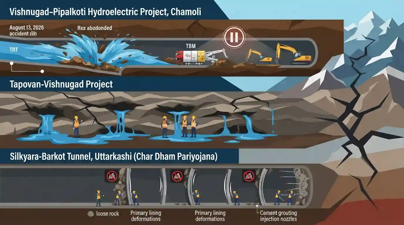
This article highlights the safety challenges and structural scrutinies facing critical tunnel and hydroelectric projects in the geologically fragile Himalayan state of Uttarakhand. Following a water and debris flooding accident on August 13, 2026, in the under-construction Tail Race Tunnel (TRT) of the Vishnugad-Pipalkoti hydroelectric project in Chamoli, excavation remains suspended pending technical clearance. Simultaneously, the Tapovan-Vishnugad project faces persistent cavity formations and water seepage. In Uttarkashi, the Silkyara-Barkot tunnel (part of the Char Dham highway project) has detected three loose-rock zones and primary lining deformations near the Barkot excavation end, necessitating rock bolting and cement grouting to stabilise the vulnerable stretches. These recurring underground events highlight the high structural and geological hazards of infrastructure development in the seismically active and unstable zones of the Himalayas.
Key Points
- Vishnugad-Pipalkoti Hydroelectric Project (Chamoli): Excavation is suspended after a flooding accident on August 13, 2026, where water and debris entered the Tail Race Tunnel (TRT) near a sensitive breakthrough zone (the point where two separately excavated tunnel sections meet).
- Tapovan-Vishnugad Hydroelectric Project (Chamoli): Located on the Dhauliganga River, this project faces recurring geological difficulties such as cavity formations and water seepage that hamper tunneling operations.
- Silkyara-Barkot Tunnel (Uttarkashi): A critical 4.5 km tunnel under the Char Dham Highway project, executed by NHIDCL. It is currently at 74% physical and 72% financial completion, with a target date of March 31, 2027. Late August 2026 monitoring detected three new loose-rock zones and primary lining deformation beyond permissible limits on the Barkot side.
- Geological Hazards and Remediation: Experts stress that Himalayan breakthrough zones concentrate immense geological stresses, requiring rigorous, continuous monitoring rather than treating disruptions as isolated events. Standard stabilization techniques like rock bolting, cement grouting, and profile restoration are being utilized to prevent structural collapses.
Important Terms
Char Dham Mahamarg Vikas Pariyojana

A flagship 889-km, ₹12,000-crore all-weather highway widening project in Uttarakhand connecting the four prominent Himalayan pilgrimage sites: Yamunotri, Gangotri, Kedarnath, and Badrinath.
UPSC context
GS Paper III (Infrastructure/Environment); tests strategic connectivity and ecological sustainability trade-offs in fragile mountains.
National Highways and Infrastructure Development Corporation Limited
A central public sector enterprise under the Ministry of Road Transport and Highways, tasked with designing, building, and upgrading strategic highways and tunnels in border and hilly terrains.
UPSC context
GS Paper III (Infrastructure); tests the institutional mechanisms for transport logistics in high-altitude, geopolitically sensitive border regions.
Madras Sappers
An elite engineering regiment of the Indian Army's Corps of Engineers called in for complex technical operations and high-stakes rescue missions during major infrastructure accidents.
UPSC context
GS Paper III (Disaster Management); assesses the role of military technical units in civil disaster relief and emergency rescue coordination.
Silkyara-Barkot Tunnel
A 4.53-km-long under-construction road tunnel in Uttarkashi district, part of the Char Dham project, known for a complex 17-day worker rescue operation following its collapse in 2023.
UPSC context
GS Paper III (Disaster Management); tests safety standards, geological hazards, and emergency response protocols in Himalayan infrastructure planning.
Vishnugad-Pipalkoti Hydroelectric Project
A 444 MW run-of-the-river hydropower scheme being constructed by THDC India Limited on the Alaknanda River in Uttarakhand's geologically sensitive Chamoli district.
UPSC context
GS Paper III (Energy/Environment); evaluates run-of-the-river hydroelectric viability and environmental impacts in active seismic zones.
Prelims Trap
The Tapovan-Vishnugad Hydroelectric Project is located on the Eastern Dhauliganga, a major headstream of the Alaknanda river.
Tapovan-Vishnugad is on the Western Dhauliganga (Chamoli). Eastern Dhauliganga is in Pithoragarh and flows into the Kali river system. Do not confuse the two rivers.
Static Concepts Connected
What are the five holy confluences (Panch Prayag) of Uttarakhand and their tributary rivers?
- Vishnuprayag: Alaknanda meets Western Dhauliganga here in Chamoli district.
- Nandaprayag: Alaknanda meets the Nandakini River.
- Karnaprayag: Alaknanda meets the Pindar River (originating from Pindari glacier).
- Rudraprayag: Alaknanda meets Mandakini (flowing from Kedarnath).
- Devprayag: Alaknanda meets Bhagirathi to officially form the Ganga River.
What are the primary geological fault zones defining Uttarakhand's tectonic profile?
- Main Boundary Thrust (MBT): Separates the Lesser Himalaya from the Outer Himalaya (Shivaliks), marked by high strain.
- Main Central Thrust (MCT): Separates the Great Himalaya from the Lesser Himalaya; passes directly through highly vulnerable zones of Chamoli and Uttarkashi.
- Main Frontal Thrust (MFT): The southernmost fault line where the Shivaliks meet the Indo-Gangetic alluvial plains.
Cross-Topic Patterns
MCT vulnerability & run-of-the-river projects
Seismic activity along the Main Central Thrust (MCT) directly threatens run-of-the-river projects in Chamoli and Uttarkashi, compounding landslide risks.
Strategic connectivity vs Eco-Sensitive Zones
The judicial and ecological scrutiny over the Char Dham expansion highlights the tension between border-security infrastructure and Bhagirathi Eco-Sensitive Zone mandates.

State geography questions will likely combine Alaknanda tributaries with specific district locations of controversial tunnel/hydel projects.
Linked PYQs · 3
Linked PYQs · 3
- 2024UKPSC_PRELIMSGS1
Match the hydroelectric projects with the river on which they are constructed : | Name of Project | River | |---|---| | A. Koteshwar | 1. Asan | | B. Kulhal | 2. Alaknanda | | C. Tapoban Vishnugad | 3. Bhagirathi | | D. Vishnuprayag | 4. Dhalui | A B C D
- 2025UKPSC_PRELIMSGS1
As per Uttarakhand Budget 2025-26, the amount allocated for Char Dham Road network improvement is
- 2025UKPSC_PRELIMSGS1
Which of the following is the correct order of rivers from west to east in Uttarakhand?
