Remote Sensing Study Assesses Forest Fire Activities In Uttarakhand
Source:science-iirs ↗
Why It Matters
Forest fires represent one of the most critical environmental and economic hazards in the fragile Himalayan ecosystem of Uttarakhand. Questions regarding the state's forest distribution (e.g., chir-pine and temperate species), district-level trends, and technological applications like Remote Sensing (which uses electromagnetic waves for active-fire and burn-severity mapping) are frequently featured in the UKPSC PCS Prelims General Studies syllabus.
Summary
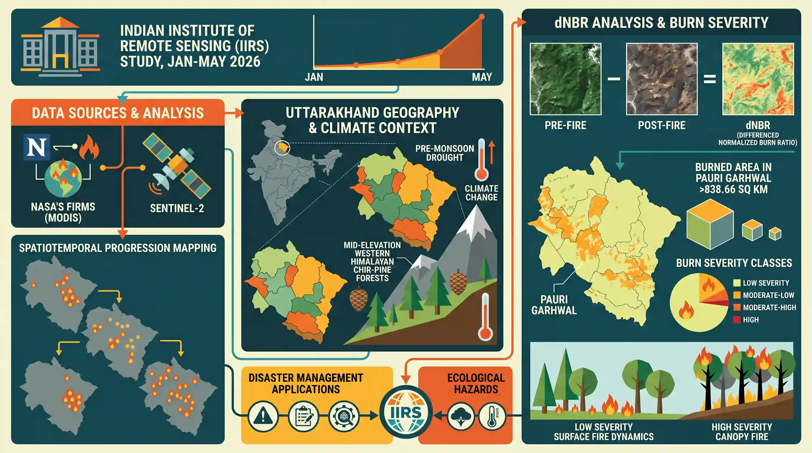
Researchers from the Indian Institute of Remote Sensing (IIRS) published a study analyzing the significant rise in Uttarakhand's forest fire activities from January to May 2026. Leveraging MODIS active-fire detections from NASA's FIRMS and Sentinel-2 satellite data, they mapped the spatial and temporal progression of the fires, concentrating heavily in Pauri Garhwal and the mid-elevation Western Himalayan chir-pine forests. By applying the differenced Normalized Burn Ratio (dNBR) index, they calculated that over 838.66 sq km was burned in Pauri Garhwal, though the ecological impact was predominantly of low severity, consistent with typical surface-fire dynamics.
Key Points
- During the first five months of 2026, Uttarakhand witnessed a sharp rise in forest fire activity, particularly during the late pre-monsoon period.
- MODIS fire detections registered 200 counts in January, fell by 43.5% in February (113 counts) due to residual winter moisture, and then steadily rose through March (178) and April (207).
- Fire activity peaked dramatically in May with 433 detections (a 109% increase over April), accounting for 38% of the seasonal total and marking a rapid shift from localized to widespread burning.
- Spatially, fire activity was concentrated in the mid-elevation forested belt of central Garhwal, with Pauri Garhwal recording the highest cumulative MODIS detections (207), followed by Chamoli (190) and Tehri Garhwal (130). Pithoragarh, Champawat, and Rudraprayag experienced the lowest activity.
- A remote-sensing burn-severity assessment for the worst-hit district (Pauri Garhwal) compared pre-fire Sentinel-2 imagery (April 2026) with post-fire composites (25-28 May 2026) using the differenced Normalized Burn Ratio (dNBR), mapping approximately 838.66 sq km of burned area.
- The assessment indicated that 81.8% (686.05 sq km) of the burned area in Pauri Garhwal experienced low-severity burns, whereas high-severity burns covered only 0.1% (0.94 sq km), aligning with the low-impact surface-fire characteristics of Western Himalayan chir-pine (Pinus roxburghii) forests.
- Active fire progression was further tracked in detail using the Shortwave Infrared (SWIR) bands of Sentinel-2 near Nalai in Pauri district.
Important Terms
Indian Institute of Remote Sensing (IIRS)

A constituent unit of ISRO based in Dehradun, established in 1966, dedicated to capacity building, education, and research in remote sensing, geoinformatics, and GIS technology for natural resource and disaster management.
UPSC context
GS Paper 3 (S&T; Disaster Management). Tests knowledge of national institutions using space technology for environmental monitoring and hazard assessment.
Indian Space Research Organisation (ISRO)
India's national space agency, headquartered in Bengaluru, established in 1969 under the Department of Space to develop and harness space technology for national development and planetary exploration.
UPSC context
GS Paper 3 (S&T). Tests awareness of India's indigenous space program, satellite launches, and applications in socio-economic development.
National Aeronautics and Space Administration (NASA)
An independent agency of the United States federal government, established in 1958, responsible for the civilian space program, aeronautics, and aerospace research.
UPSC context
GS Paper 3 (S&T). Tests understanding of global space agencies, international collaborations, and landmark space exploration missions.
European Space Agency (ESA)
An intergovernmental organization of 22 member states, established in 1975 and headquartered in Paris, dedicated to peaceful space exploration, research, and European integration.
UPSC context
GS Paper 3 (S&T). Tests knowledge of international space programs, Earth observation initiatives, and joint global missions.
Prelims Trap
The Normalized Burn Ratio (NBR) indicates that both Near-Infrared (NIR) and Shortwave Infrared (SWIR) spectral reflectances decrease after a forest fire.
dNBR relies on opposite spectral shifts: NIR reflectance decreases (due to canopy damage) while SWIR reflectance increases (due to dry, exposed soil). It is false to state both decrease.
Static Concepts Connected
How do NIR and SWIR bands behave differently in post-fire remote sensing assessments?
- NIR response: Healthy green vegetation has high reflectance in the Near-Infrared (NIR) spectrum due to chlorophyll, which drops sharply after a fire destroys the canopy.
- SWIR response: Exposed dry soil, ash, and charcoal absorb less and reflect more in the Shortwave Infrared (SWIR) spectrum post-fire, causing SWIR reflectance to rise.
- NBR formulation: Calculated as (NIR - SWIR) / (NIR + SWIR), where a high positive value indicates healthy vegetation and a negative/low value indicates severe burns.
What makes Chir-pine forests highly vulnerable yet uniquely adapted to Himalayan fires?
- Combustible litter: Chir-pine needles (pirul) are rich in resin, highly inflammable, and decay very slowly, accumulating on the forest floor to create a persistent fuel load.
- Surface vs Crown: These forests typically experience low-severity surface fires that consume ground litter rather than destructive crown fires that consume the entire canopy.
- Thick-bark adaptation: Mature trees possess thick, layered bark that insulates the vital cambium layer, allowing them to survive regular seasonal surface burns.
Cross-Topic Patterns
Space tech in Indian disaster protocols
Integrating Sentinel-2 and MODIS dNBR data into NDMA forest fire protocols shifts disaster governance from reactive suppression to proactive, space-based fuel-load monitoring and early hazard warning.
Pine monocultures vs. Community Forest Rights
Colonial substitution of native Himalayan oaks with highly flammable Chir-pine monocultures directly links ecological forest fire vulnerability to the socio-economic stewardship of local Van Panchayats.

UPSC 2026 may test the physical principles of remote sensing indices (like dNBR) alongside Western Himalayan pine-fire ecology.
Linked PYQs · 4
Linked PYQs · 4
- 2021UKPSC_PRELIMSGS1
Remote Sensing uses which of the following in its applications?
- 2024UKPSC_PRELIMSGS1
Which district of Uttarakhand has highest forest cover share percentage to its total geographical area ?
- 2016UKPSC_PRELIMSGS1
In Uttarakhand, Oak-Rhododendron are characteristic plants of
- 2025UKPSC_PRELIMSGS1
Consider the following statements and select the correct answer from the options given below : Statement 1 : Uttarakhand is highly vulnerable to climate change. Statement 2 : Climate change is causing water stress and depleting biodiversity in Uttarakhand.
