Chamoli Earthquake: MCT Faults and Himalayan Seismic Risks
Source:indiatoday ↗
Why It Matters
Highly relevant for UKPSC PCS Prelims regarding Uttarakhand's physical geography, fault lines (MCT/MBT), and seismic vulnerability of the Himalayan region.
Summary
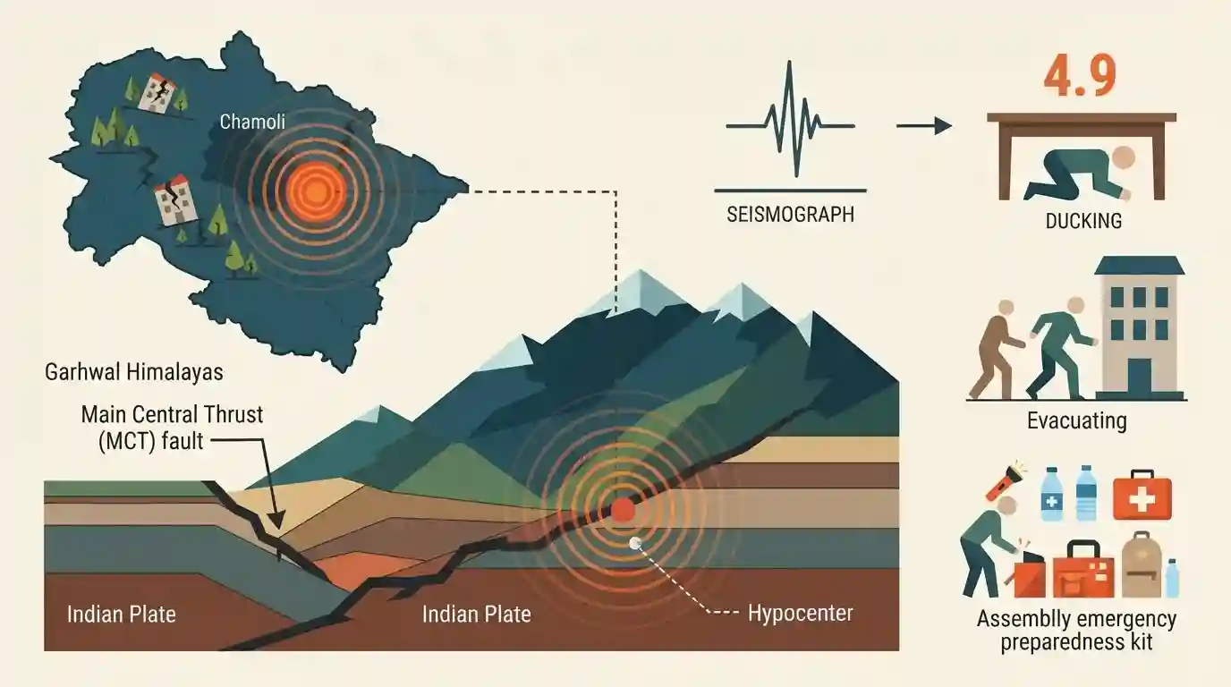
An earthquake measuring 4.9 in magnitude shook Chamoli and surrounding areas in Uttarakhand, emphasizing the fragile tectonic framework of the Garhwal Himalayas and active fault systems like the Main Central Thrust (MCT).
Key Points
- An earthquake of magnitude 4.9 hit Chamoli district in Uttarakhand, triggering minor tremors.
- The region's seismicity is driven by complex fault systems and tectonic movements within the Himalayan orogenic belt, notably near the Main Central Thrust (MCT).
- Uttarakhand lies predominantly in high seismic zones (Zones IV and V), making it exceptionally vulnerable to seismic hazards.
Important Terms
National Center for Seismology

India's primary nodal agency under the Ministry of Earth Sciences responsible for monitoring earthquake activity, operating seismic networks, and disseminating real-time earthquake data across the country.
UPSC context
Essential for GS Paper III (Disaster Management); tests institutional setup and real-time hazard monitoring mechanisms in India.
Main Central Thrust (MCT)
A major regional tectonic boundary in the Himalayas separating the Higher Himalayan crystalline rocks from the Lesser Himalayan sequences, acting as a primary zone of seismic activity.
UPSC context
Important for UKPSC (Geography of Uttarakhand & Geology); tests knowledge of Himalayan fault systems and seismotectonic frameworks.
Central Seismic Gap
A 700-km-long segment of the Himalayan arc between the rupture zones of the 1905 Kangra and 1934 Bihar earthquakes, historically deficient in major earthquakes and storing significant strain.
UPSC context
Crucial for Geography of Uttarakhand and Disaster Management; tests understanding of seismic vulnerability and high-magnitude earthquake potential in the Himalayas.
Prelims Trap
The Main Central Thrust (MCT) lies to the south of the Main Boundary Thrust (MBT) in the Himalayan cross-section.
Aspirants often confuse the Main Boundary Thrust (MBT) with the Main Central Thrust (MCT), assuming MCT is south of MBT, whereas MCT lies further north.
Static Concepts Connected
What are the major tectonic thrust zones of the Himalayas from south to north?
- HFT Boundary: Himalayan Frontal Thrust (HFT) marks the southernmost boundary separating the Siwaliks from the Indo-Gangetic plains.
- MBT Fault: Main Boundary Thrust (MBT) separates the Outer Himalayas (Siwaliks) from the Lesser Himalayas.
- MCT Fault: Main Central Thrust (MCT) separates the Lesser Himalayas from the Higher Himalayas, associated with high seismicity.
- ITSZ Suture: Trans-Himalayan Lineament / Indus-Tsangpo Suture Zone (ITSZ) marks the collision suture between Indian and Eurasian plates.
Cross-Topic Patterns
Himalayan Tectonics & Seismic Zonation
Uttarakhand's high seismicity is directly tied to the ongoing northward convergence of the Indian plate against the Eurasian plate, creating dynamic orogenic stress belts.
Disaster Management & Structural Vulnerability
Vulnerability in Zones IV and V mandates strict adherence to NBC building codes and retrofitting of infrastructure in hill districts.

Himalayan thrust systems (MCT, MBF, HFT) + Seismic Zones IV/V often appear in matching or assertion-reason questions.
Linked PYQs · 2
Linked PYQs · 2
- 2025UKPSC_PRELIMSGS1
Which of the following parts of Himalaya is situated between Main Boundary Thrust and Main Central Thrust ?
- 2025UKPSC_PRELIMSGS1
Consider the following statements and select the correct answer from the options given below : Statement 1 : Uttarakhand is highly vulnerable to climate change. Statement 2 : Climate change is causing water stress and depleting biodiversity in Uttarakhand.
