Uttarakhand sanctions funds for GIS drainage systems
Source:ani ↗
Why It Matters
Highlights the state government's targeted interventions in urban planning and disaster resilience, particularly using GIS technology for drainage and structural flood control measures on Himalayan rivers. Such state-specific infrastructure initiatives are highly relevant for UKPSC Prelims and Mains (State-Specific GS).
Summary
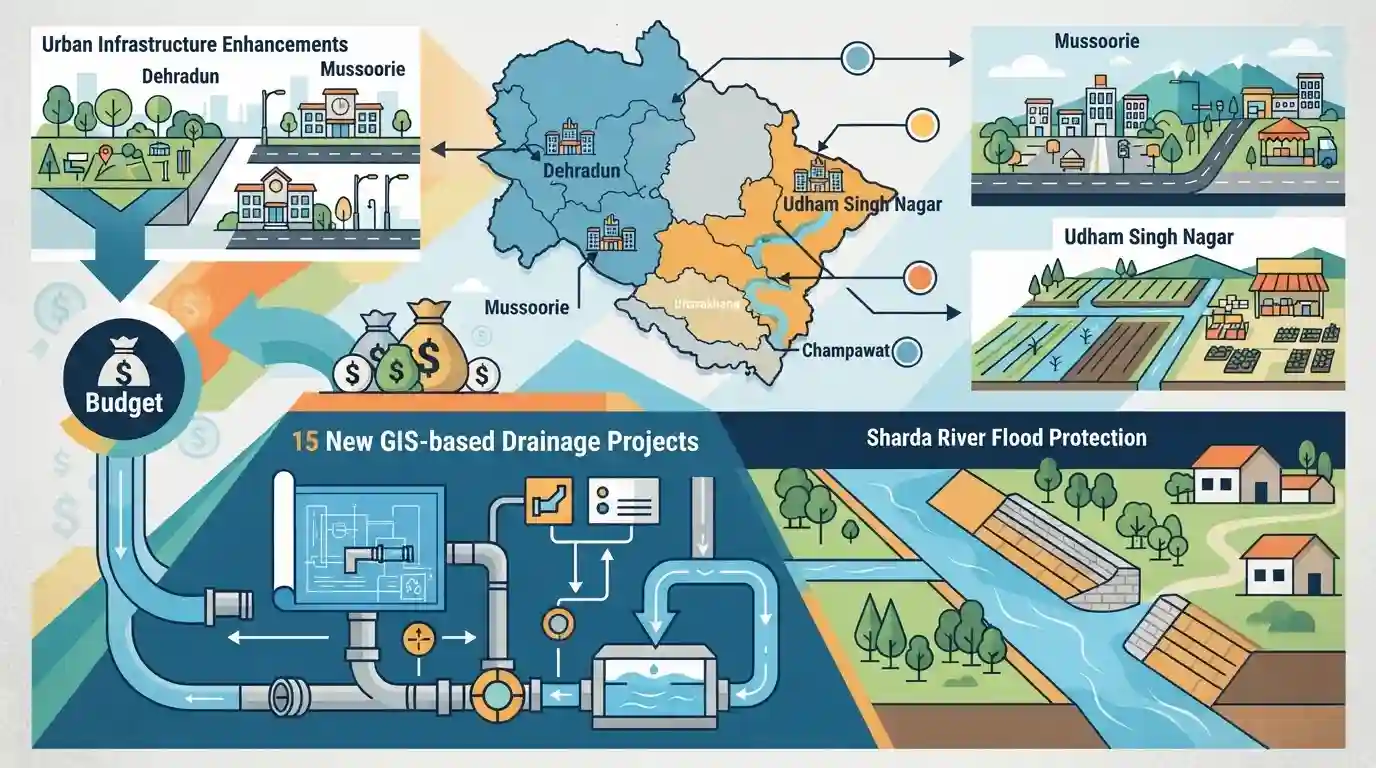
Uttarakhand Chief Minister Pushkar Singh Dhami has approved an allocation of Rs 1,967 crore to enhance urban infrastructure, with a primary focus on mitigating waterlogging through 15 new GIS-based drainage projects funded at Rs 1,960 crore. The approved budget also encompasses a vital flood protection initiative on the Sharda River in Champawat district, as well as targeted infrastructure improvements and community facilities in Dehradun, Mussoorie, and Udham Singh Nagar.
Key Points
- Uttarakhand CM Pushkar Singh Dhami has approved Rs 1,967 crore for strengthening urban infrastructure in the state.
- A major chunk of Rs 1,960 crore is allocated for implementing 15 GIS-based drainage projects across various districts to resolve waterlogging issues.
- A flood protection project worth Rs 6.82 crore was approved to safeguard Khet Kheda village on the banks of the Sharda River in Champawat district.
- Additionally, infrastructure projects worth Rs 17.80 crore were initiated for the Mussoorie assembly constituency, including the inauguration of a community hall in Dehradun.
Important Terms
GIS-based drainage projects

The use of Geographic Information Systems (GIS) to digitally map, model, and manage urban storm-water networks, allowing authorities to optimize water flow and scientifically mitigate urban waterlogging.
UPSC context
GS-3 Technology & Disaster Management. Tests the application of geospatial technology in urban planning and flood mitigation.
Sharda River flood protection project
Infrastructure initiatives—such as those safeguarding vulnerable villages in Champawat—designed to prevent erosion and inundation along the Sharda River, a highly volatile Himalayan river forming the India-Nepal border.
UPSC context
GS-1 Geography & GS-3 Disaster Management. Tests knowledge of Himalayan river systems, international boundaries, and flood mitigation.
State Level High Power Steering Committee
An apex state-level administrative body, typically chaired by the Chief Secretary, responsible for approving, funding, and monitoring major urban infrastructure and rejuvenation schemes (like AMRUT) within a state.
UPSC context
GS-2 Governance. Relevant for understanding institutional mechanisms, Centrally Sponsored Scheme implementation, and decentralized decision-making in urban governance.
Prelims Trap
"The Sharda river flows exclusively within Indian territory and directly joins the river Ganga as a left-bank tributary."
The Sharda (Mahakali) river forms the India-Nepal boundary. It does not join the Ganga directly; it merges with the Ghaghara, which later joins the Ganga.
Static Concepts Connected
What is the geographical course and significance of the Sharda (Mahakali) River?
- Origin & Boundary: Originates at Kalapani in the Himalayas, serving as a natural riverine boundary demarcating Nepal's western border with India.
- Tributary System: Flows into the Terai plains of UP and merges with the Ghaghara River, a major left-bank tributary of the Ganges.
- Bilateral Treaty: Governed by the 1996 Mahakali Treaty between India and Nepal, which establishes the framework for the binational Pancheshwar Multipurpose Project.
How does NDMA classify and manage Urban Flooding?
- Separate Classification: NDMA delinked Urban Flooding from rural riverine flooding in 2010, noting urban catchments increase flood peaks by 1.8 to 8 times due to rapid runoff.
- GIS Utility: Geographic Information Systems (GIS) overlay spatial drainage networks with demographic data to map vulnerabilities and identify high-risk urban zones.
Cross-Topic Patterns
Urban Flooding + GIS Technologies
Linking GIS drainage mapping in hill states to GS3 Disaster Management. UPSC frequently tests the application of spatial technologies in mitigating climate-induced urban disasters.
River Boundaries + Hydro-diplomacy
Flood protection on the Sharda river intersects with GS2 International Relations, specifically the Mahakali Treaty and the broader context of India-Nepal border mapping (Kalapani).

Expect a multi-statement Prelims question merging the Sharda (Mahakali) river's geographical mapping with India-Nepal hydro-diplomacy.
Linked PYQs · 3
Linked PYQs · 3
- 2024UKPSC_PRELIMSGS1
Match the hydroelectric projects with the river on which they are constructed : | Name of Project | River | |---|---| | A. Koteshwar | 1. Asan | | B. Kulhal | 2. Alaknanda | | C. Tapoban Vishnugad | 3. Bhagirathi | | D. Vishnuprayag | 4. Dhalui | A B C D
- 2024UKPSC_PRELIMSGS1
Which of the following stream is the tributary of Girthi river in Uttarakhand ?
- 2025UKPSC_PRELIMSGS1
As per Uttarakhand Budget 2025-26, the amount allocated for Char Dham Road network improvement is
