Monsoon Trough Shift and Uttar Pradesh Rainfall Forecast
Source:theprint ↗
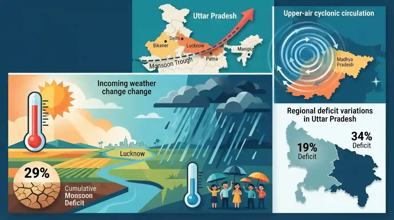
Why It Matters
Understanding the mechanics of the Indian Monsoon, specifically factors like the monsoon trough and cyclonic circulations, is a core geographical concept for UPPSC. Moreover, knowledge of the IMD's history and state-specific climate data (e.g., variations between Eastern and Western UP rainfall) is frequently tested in both Prelims and Mains.
Summary
The India Meteorological Department (IMD) has forecast an intense spell of rainfall across Uttar Pradesh over the next 4-5 days, promising much-needed relief from severe humid conditions and lowering maximum temperatures by 4-6 degrees Celsius. This weather shift is attributed to two primary meteorological factors: the northward movement of the monsoon trough (currently passing through Bikaner, Delhi, Lucknow, Patna, and extending to Manipur) and a strengthening upper-air cyclonic circulation over northern Madhya Pradesh and adjoining southern UP. The incoming rain is critical for the state, which has experienced a cumulative 29% monsoon deficit this season, with stark regional variations between East UP (34% deficit) and West UP (19% deficit).
Key Points
- The IMD predicts intense rainfall in Uttar Pradesh over 4-5 days, providing relief from high humidity and reducing maximum temperatures by 4-6 degrees Celsius.
- UP is currently facing a 29% overall monsoon rainfall deficit, with East UP experiencing a 34% shortfall and West UP a 19% shortfall.
- The expected rainfall is driven by the northward shift of the monsoon trough, which currently extends from Bikaner through Delhi, Lucknow, and Patna to Manipur.
- An active upper-air cyclonic circulation over northern Madhya Pradesh and southern Uttar Pradesh is further enhancing monsoon activity in the region.
Important Terms
India Meteorological Department (IMD)

India's principal agency for meteorological observations and weather forecasting. Established in 1875 under the Ministry of Earth Sciences, it issues monsoon predictions, cyclone alerts, and provides crucial climate data for agriculture and disaster management.
UPSC context
GS Papers 1 & 3 (Geography, Disaster Management). Tests knowledge of its nodal ministry, early warning systems, and regional cyclone naming mandate.
Monsoon Trough
An elongated low-pressure area representing the summer position of the Inter-Tropical Convergence Zone (ITCZ) over India. Extending from Rajasthan to the Bay of Bengal, its north-south oscillations dictate active rainfall and dry break periods.
UPSC context
GS Paper 1 (Physical Geography). Essential for understanding Indian monsoon dynamics, rainfall distribution mechanisms, and break monsoon conditions.
Upper-Air Cyclonic Circulation
A closed, counterclockwise wind circulation around a low-pressure center in the mid-to-upper atmosphere (Northern Hemisphere). It forces warm, moist air upwards, facilitating condensation, cloud formation, and intensified rainfall over a specific region.
UPSC context
GS Paper 1 (Climatology). Important for questions on atmospheric pressure systems, cyclogenesis, and factors triggering localized extreme weather events.
Monsoon Deficit
A shortfall in seasonal precipitation where a region receives significantly less rainfall than its Long Period Average (LPA). It highlights spatial weather variations and can trigger agricultural distress and drought conditions if prolonged.
UPSC context
GS Papers 1 & 3 (Geography, Agriculture, Economy). Relevant for evaluating drought vulnerability, crop yields, and water resource management in India.
Prelims Trap
"Northward shift of the monsoon trough always leads to dry conditions (a break) in the northern Indian plains."
A shift to the Indo-Gangetic plains actually causes intense rain there. A dry 'break' only occurs when the trough migrates completely to the Himalayan foothills.
Static Concepts Connected
What causes a 'Break in the Monsoon' and how does it alter rainfall distribution?
- Trough Shift: The monsoon trough migrates completely northward to rest along the Himalayan foothills, abruptly halting precipitation over the northern and central Indian plains.
- Regional Flooding: While the plains remain dry, heavy and concentrated rainfall occurs in the Himalayan foothills and Northeast India, frequently causing severe riverine flooding.
- Temporal Occurrence: These dry spells typically last from a few days to a couple of weeks, most commonly occurring during the peak monsoon months of July and August.
How does an upper-air cyclonic circulation intensify surface-level monsoon rainfall?
- Upper Divergence: The cyclonic circulation creates air divergence in the upper troposphere, acting like a giant exhaust mechanism that pulls air upwards.
- Surface Low Pressure: This upward suction forces moist air from the lower atmosphere to rise, generating a strong low-pressure zone (convergence) at the surface.
- Condensation & Rain: As the moist surface air ascends, it cools and condenses to form thick rain-bearing clouds, heavily intensifying the monsoon precipitation in that region.
Cross-Topic Patterns
Spatial monsoon deficits & agricultural stress
UP's uneven deficit (34% East vs 19% West) mirrors India's structural agricultural challenge, linking climatological phenomena directly to crop yield disparities and rural distress in rainfed regions.
Trough dynamics & Disaster Management
The monsoon trough's movement dictates flood/drought cycles. When it aligns perfectly with the foothills, it triggers Assam and Bihar floods, while central India faces simultaneous agricultural dry spells.

Expect a multi-statement 2026 Prelims question testing the spatial rainfall impacts of the Monsoon Trough's position vs. El Niño.
Linked PYQs · 2
Linked PYQs · 2
- 2018UPPSC_PRELIMSGS1
Arrange the following India Meteorological Headquarters in Chronological order of their establishment and select your correct answer from the codes given below: A. New Delhi B. Kolkata C. Shimla D. Pune
- 2021UPPSC_PRELIMSGS1
Which one of the following causes is responsible for rainfall during winters in north-western part of India ?
