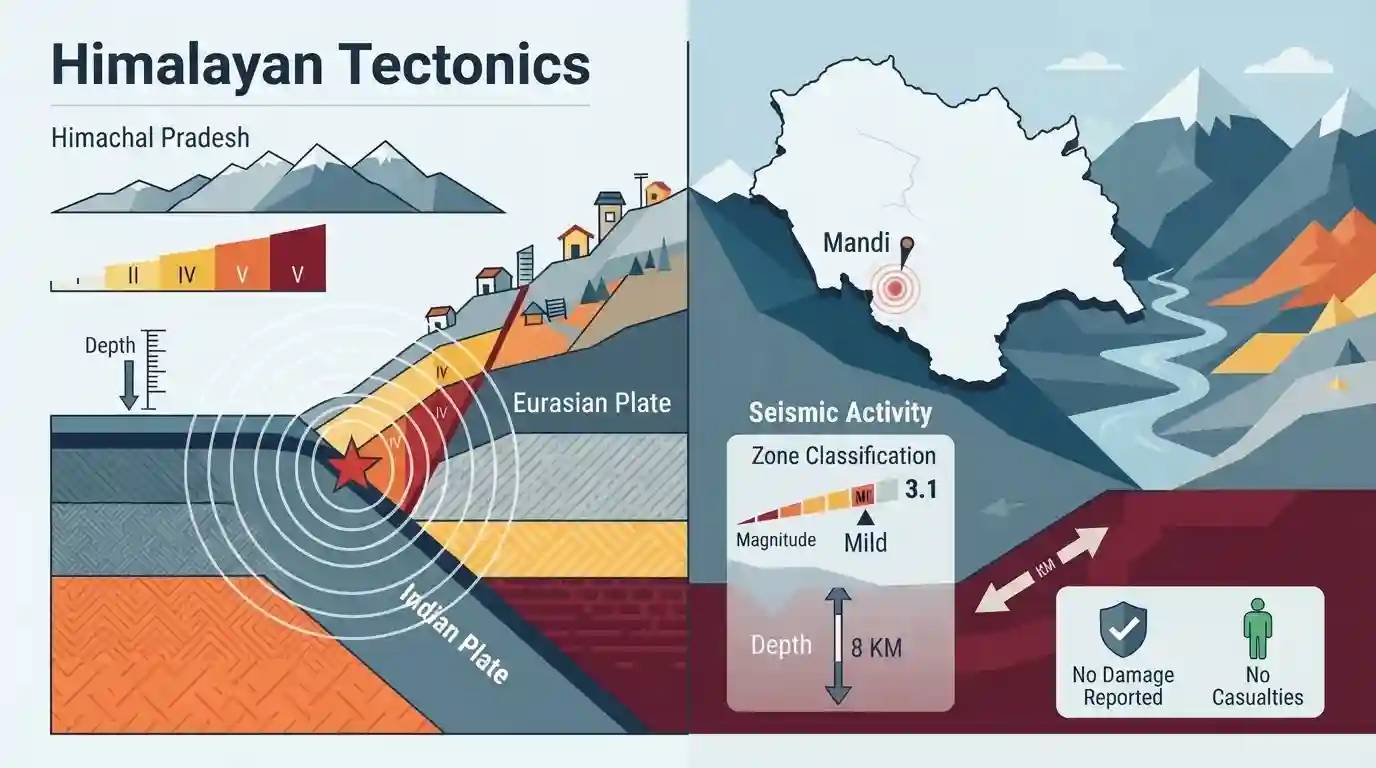
Mild earthquake of magnitude 3.1 hits Mandi district in Himachal
Source:tribuneindia ↗
Why It Matters
Earthquakes and seismic zonation are core topics in Physical Geography and Disaster Management. Himachal Pradesh's placement in Seismic Zones IV and V makes it a frequent focal point for HPAS Prelims questions regarding Himalayan seismicity, tectonic plate boundaries, and disaster vulnerability mapping.
Summary
A mild earthquake measuring 3.1 on the Richter scale struck Mandi district in Himachal Pradesh, with an epicentre at a depth of 8 kilometers. Confirmed by the National Centre for Seismology, the tremors caused no reported damage or casualties. The event serves as a reminder of the region's high seismic vulnerability, as parts of Himachal Pradesh fall under Seismic Zones IV and V due to ongoing tectonic movements in the Himalayas.
Key Points
- A mild earthquake of 3.1 magnitude on the Richter scale was recorded in Mandi district of Himachal Pradesh.
- The earthquake occurred at a shallow depth of 8 kilometers.
- No loss of life or property was reported due to the mild intensity of the tremors.
- Himachal Pradesh lies in the highly active seismic zones (Zone IV and Zone V), making it highly vulnerable to earthquakes due to the collision of the Indian and Eurasian tectonic plates.
Important Terms
National Centre for Seismology

The nodal agency under India's Ministry of Earth Sciences responsible for monitoring earthquake activity, maintaining the National Seismological Network, and conducting seismic hazard microzonation studies.
UPSC context
GS Paper III (Disaster Management); tests understanding of the institutional framework for monitoring geological hazards in India.
Seismic Zones of India
Geographic divisions defined by the Bureau of Indian Standards (BIS) to categorize different regions of India based on expected earthquake intensity and seismic hazard levels.
UPSC context
GS Paper I (Physical Geography) and GS Paper III (Disaster Management); evaluates knowledge of regional hazard vulnerability and mitigation planning.
Himalayan Tectonics
The geologic processes and plate interactions resulting from the collision between the Indian and Eurasian tectonic plates, causing high seismicity and mountain building in the Himalayas.
UPSC context
GS Paper I (Physical Geography); tests understanding of plate tectonics, geomorphology, and structural vulnerabilities in northern India.
Seismic Hazard Microzonation
The process of dividing a seismic region into smaller areas based on localized geological, soil, and geotechnical factors that impact earthquake ground motion intensity.
UPSC context
GS Paper III (Disaster Management); tests knowledge of advanced urban planning, hazard mapping, and structural mitigation strategies.
Epicentre
The specific point on the Earth’s surface vertically directly above the focus (or hypocentre) where an earthquake rupture initiates.
UPSC context
GS Paper I (Physical Geography); checks grasp of foundational concepts in seismology and Earth sciences.
Prelims Trap
India is divided into five active seismic hazard zones, ranging from Zone I (lowest risk) to Zone V (highest risk).
Zone I is no longer part of India's seismic zonation. The Bureau of Indian Standards (BIS) merged Zone I into Zone II to mandate minimum safety design.
Static Concepts Connected
How does the BIS classify India's four seismic zones?
- Zone II: Represents low seismic intensity. It covers approximately 41% of the country's landmass, including stable peninsular shield areas.
- Zone III: Represents moderate seismic intensity. It includes metropolitan cities like Mumbai, Chennai, and Kolkata, alongside parts of the Indo-Gangetic basin.
- Zone IV: Indicates high seismic risk. It covers the Indo-Gangetic plain, Delhi, Jammu and Kashmir, and parts of Himachal Pradesh.
- Zone V: Represents the highest seismic hazard. Covers the entire North-East, Andaman and Nicobar Islands, and parts of Kutch (Gujarat).
How do Magnitude, Intensity, and Focal Depth differ?
- Richter Scale: Measures quantitative energy released at the focus. It is logarithmic, meaning each whole number step represents a 31.6 times increase in energy.
- Mercalli Scale: Measures qualitative, localized damage and human perception on a scale of I to XII. It varies by distance from the epicentre.
- Focal Depth: Earthquakes with shallow depths (0-70 km) cause maximum destruction as seismic waves travel less distance and lose less energy.
Cross-Topic Patterns
Tectonic activity vs. Himalayan infrastructure
Ongoing Indian-Eurasian plate convergence makes mega-infrastructure (dams, tunnels) in Zones IV/V highly vulnerable, requiring stringent environmental impact assessments.
Seismic codes and municipal compliance
High-hazard classifications in hill states highlight a critical regulatory gap: the lack of mandatory enforcement of BIS building codes in local municipal bylaws.

Expect questions linking plate convergence rates, shallow-focus mechanics, and the exclusion of Zone I in BIS hazard maps in 2026.
Linked PYQs · 2
Linked PYQs · 2
- 2025HPAS_PRELIMSGS1
Mountain Soil Zone in Himachal Pradesh is found between :
- 2024HPAS_PRELIMSGS1
Match the forest cover area/type with their total area in Himachal Pradesh (2021) : | List I (Density/Total Forest Cover) | List II (Area in sq. kms.) | |---|---| | (a) Very dense forest above 70 percent | (i) 7,100 | | (b) Moderate dense forest 40 to 70 percent | (ii) 5,180 | | (c) Open forest 10 percent to 40 percent | (iii) 15,443 | | (d) Total forest cover | (iv) 3,163 | Choose the correct options : Code: (a) (b) (c) (d)
