Rising Water Levels in Ghepan Lake Set Alarm in Lahaul Spiti District
Source:hillpost ↗
Why It Matters
Important for HPAS aspirants regarding regional geography, environmental vulnerabilities, climate change impacts, and disaster management systems specific to Himachal Pradesh's fragile Himalayan ecosystem.
Summary
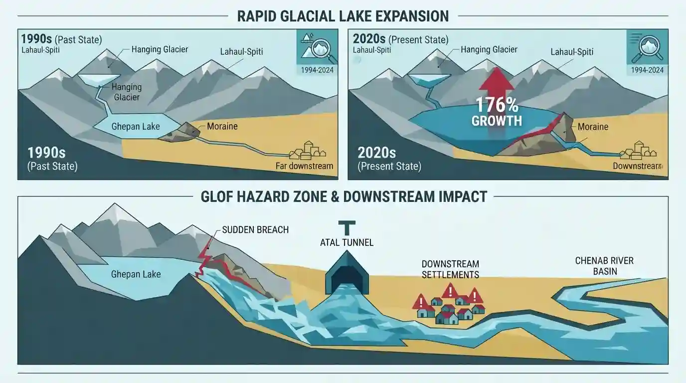
Scientists and disaster management authorities have raised alarms over the rapidly expanding Ghepan Lake in the Lahaul-Spiti district of Himachal Pradesh. Characterized as a moraine-dammed lake fed by hanging glaciers, its massive growth of over 176% in three decades presents a severe Glacial Lake Outburst Flood (GLOF) hazard to downstream settlements, infrastructure like the Atal Tunnel, and the Chenab River basin.
Key Points
- Ghepan Lake in Lahaul-Spiti district, Himachal Pradesh, has expanded by over 176% over three decades (from 36.5 hectares to over 101 hectares), raising serious Glacial Lake Outburst Flood (GLOF) concerns.
- Hydro-geological models warn that a breach could send floodwaters reaching Sissu village in 21 minutes, threatening 34 settlements, 204 hectares of land, 57 bridges, and critical infrastructure like the Manali-Leh National Highway and Atal Tunnel.
- The outflow feeds into the Chenab River basin, potentially impacting downstream regions in Chamba, Jammu & Kashmir, and Pakistan.
- Authorities are deploying real-time water level sensors, communication grids, and conducting structural profiling of the moraine dam via GSI, NDMA, and C-DAC.
Important Terms
Ghepan Lake

A moraine-dammed glacial lake fed by hanging glaciers in Lahaul-Spiti, HP, which has expanded dramatically over recent decades, posing a high Glacial Lake Outburst Flood (GLOF) hazard to downstream settlements and infrastructure.
UPSC context
HPAS Paper III (Geography/Disaster Management): Tests knowledge of regional ecological vulnerabilities, climate change impacts, and GLOF risks in Himachal Pradesh.
National Disaster Management Authority (NDMA)
The apex statutory body for disaster management in India, headed by the Prime Minister, responsible for framing policies, laying down guidelines, and coordinating disaster response and mitigation.
UPSC context
HPAS Paper III (Disaster Management): Tests institutional frameworks, policies, and national-level mitigation strategies for natural disasters.
C-DAC
A premier R&D organization under the Ministry of Electronics and Information Technology (MeitY) that develops advanced technological solutions, including Early Warning Systems for glacial lakes.
UPSC context
HPAS Paper III (Science and Technology): Tests understanding of indigenous technological applications in disaster management and early warning infrastructure.
Geological Survey of India (GSI)
An attached office of the Ministry of Mines that provides scientific surveys, geological mapping, and hazard assessments, including studies on landslide and GLOF vulnerabilities.
UPSC context
HPAS Paper III (Geography/Science): Tests familiarity with scientific mapping agencies and institutional mechanisms for geo-hazard assessment.
Static Concepts Connected
What are the primary causes and mitigation strategies for Glacial Lake Outburst Floods (GLOFs) in the Himalayas?
- Trigger Mechanism: Moraine dam failure triggered by avalanches, earthquakes, or rapid ice melting forms the primary physical mechanism of GLOFs.
- Engineering Mitigation: Siphon systems and controlled channel excavation are deployed to lower water levels in high-risk glacial lakes.
- Early Warning: Early Warning Systems (EWS) and real-time sensors provide crucial lead time for vulnerable downstream settlements.
Cross-Topic Patterns
Glacial Lake Hazards and Disaster Management in HP
Rising GLOF risks in Lahaul-Spiti link fragile Himalayan cryosphere science with disaster management strategies under NDMA guidelines for HPAS GS Paper III.

Expect a multi-statement question on GLOF vulnerability in Lahaul-Spiti, specifically targeting Ghepan Lake dimensions and downstream infrastructure threats.
Linked PYQs · 1
Linked PYQs · 1
- 2023HPAS_PRELIMSGS1
Given below are two statements : Statement I : Chandra Tal lake in Lahaul and Spiti district of Himachal Pradesh is about 6000 m above sea level. Statement II : Suraj Tal lake is the source of Spiti river in Himachal Pradesh. In the light of the above statements, choose the most appropriate answer from the options given below :
