Supreme Court Suo Motu Cognisance on Aravalli Hills Definition
Source:The Hindu ↗
Why It Matters
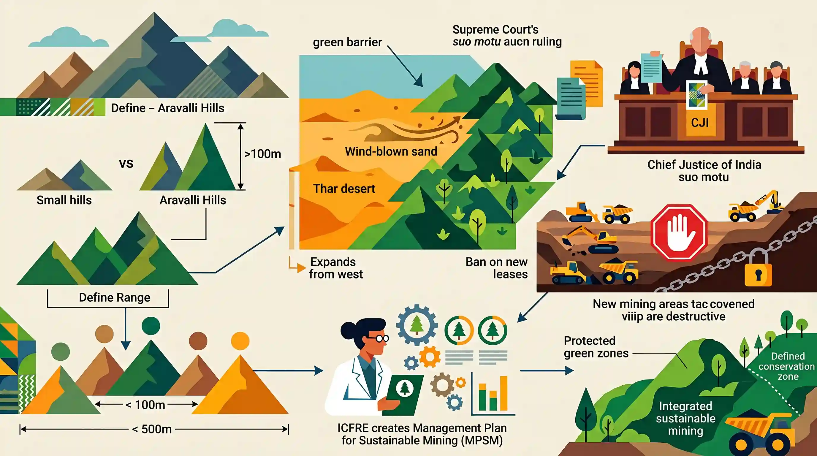
The Aravalli range serves as a critical ecological bulwark against desertification in North-West India. This issue highlights the tension between land use/commercial mining and ecological preservation, while also serving as a prime example of judicial intervention (suo motu cognisance) in enforcing environmental sustainability and demarcating protected 'No-Go' zones.
Summary
The Supreme Court of India has taken suo motu cognisance of the controversy surrounding the redefinition of the Aravalli Hills and Range. A Special Vacation Bench headed by CJI Surya Kant is reviewing the MoEFCC committee's accepted definitions, which classify an 'Aravalli Hill' as having an elevation of 100 meters or more above local relief and a 'Range' as a cluster of such hills within 500 meters. Acknowledging the Aravallis as a crucial 'green barrier' against the eastward spread of the Thar desert, the Court has banned all new mining leases until a comprehensive Management Plan for Sustainable Mining (MPSM) is finalized by the Indian Council of Forestry Research and Education (ICFRE). The case underscores the judiciary's ongoing role in demarcating conservation-critical zones and regulating ecologically hazardous activities.
Key Points
- The Supreme Court has set up a Special Vacation Bench headed by CJI Surya Kant to take suo motu cognisance of the recent redefinition of the Aravalli Hills and Range.
- An Aravalli Hill is defined as any landform with an elevation of 100 meters or more from the local relief, and a Range as two or more such hills within 500 meters of each other.
- The Court directed the MoEFCC, through the Indian Council of Forestry Research and Education (ICFRE), to finalize a Management Plan for Sustainable Mining (MPSM).
- A blanket ban has been placed on granting new mining leases in the region until the MPSM is officially finalized.
- The Aravalli landscape is legally recognized for its ecological importance as a 'green barrier' that prevents the eastward spread of the Thar desert.
Important Terms
Aravalli Range

India's oldest fold mountain system stretching from Gujarat to Delhi. It serves as a 'green barrier' against the Thar Desert's expansion and is crucial for groundwater recharge and biodiversity in Northwest India.
UPSC context
GS Paper I & III. Essential for studying Indian geomorphology, climate barriers, and environmental conservation strategies.
Management Plan for Sustainable Mining (MPSM)
A scientific regulatory framework mandated by the Supreme Court to identify permissible mining zones. It assesses ecological carrying capacity and outlines restoration measures, modeled after the Saranda forest plan.
UPSC context
GS Paper III. Tests understanding of sustainable mineral resource management and the judiciary's role in ecological governance.
Indian Council of Forestry Research and Education (ICFRE)
An autonomous body under the MoEFCC responsible for forestry research. The Supreme Court tasked it with creating the MPSM and demarcating sensitive Aravalli zones to regulate mining scientifically.
UPSC context
GS Paper III. Important for exams regarding autonomous bodies involved in conservation and scientific land-use planning.
Central Empowered Committee (CEC)
A permanent statutory body established by the Supreme Court to monitor environmental orders and advise on forest conservation. It recently flagged concerns over redefining the Aravalli Hills based solely on elevation.
UPSC context
GS Paper II & III. Relevant for understanding judicial activism, environmental oversight mechanisms, and the intersection of law and ecology.
Suo Motu
A Latin term meaning "on its own motion." It refers to the power of Indian courts to take up a case without a formal petition from an aggrieved party.
UPSC context
GS Paper II (Judiciary). Tests knowledge of the Supreme Court's powers, judicial activism, and original jurisdiction.
Desertification
The process of fertile land becoming desert due to drought, deforestation, or inappropriate agriculture. The Aravallis act as a critical buffer, preventing the 'eastward spread' of the Thar Desert.
UPSC context
GS Paper I & III. Core topic for geography and environment, focusing on land degradation and ecological barriers.
Prelims Trap
An Aravalli Hill is defined as having an elevation of 100 meters or more above Mean Sea Level.
The new definition explicitly sets the metric at 100 meters above 'local relief', not 'Mean Sea Level' (MSL). Confusing these two is a classic UPSC geographical measurement trap.
Static Concepts Connected
What are the key geographical features of the Aravalli Range?
- Relict Fold Mountains: Formed during the Proterozoic era, they are among the world's oldest fold mountains, now surviving only as highly denuded relict mountains.
- Geographical Extent: Spans approximately 670 km across four states/UTs: from Palanpur in Gujarat, through Rajasthan and Haryana, terminating at the Delhi Ridge.
- Climatic Divide: Acts as a crucial water divide between the Indus and Ganga river basins, and functions as a physical barrier against wind-blown desertification.
What is the Indian Council of Forestry Research and Education (ICFRE)?
- Apex Research Body: An autonomous organization under the Ministry of Environment, Forest and Climate Change (MoEFCC) headquartered in Dehradun.
- Core Mandate: Responsible for directing and managing research, education, and extension in forestry, including framing specialized frameworks like the Management Plan for Sustainable Mining (MPSM).
Cross-Topic Patterns
Aravallis + Great Green Wall
The Aravalli conservation crisis links directly to India's "Great Green Wall" proposal and UNCCD commitments to halt the eastward expansion of the Thar desert.
Judicial Activism + Forest Governance
Echoes the landmark T.N. Godavarman case, showcasing how the Supreme Court frequently uses suo motu powers to fill executive gaps in defining and protecting ecological zones.

Expect a 2026 multi-statement question combining Aravalli's geological age, extent, and role as a barrier to Thar desertification.
Linked PYQs · 4
Linked PYQs · 4
- 2023PrelimsGS1
Consider the following statements: 1. Amarkantak Hills are at the confluence of Vindhya and Sahyadri Ranges. 2. Biligirirangan Hills constitute the easternmost part of Satpura Range. 3. Seshachalam Hills constitute the southernmost part of Western Ghats. How many of the statements given above are correct?
- 2025MainsGS3
Mineral resources are fundamental to the country's economy and these are exploited by mining. Why is mining considered an environmental hazard? Explain the remedial measures required to reduce the environmental hazard due to mining.
- 2013MainsGS3
What are the consequences of Illegal mining ? Discuss the Ministry of Environment and Forests' concept of GO AND NO GO zones for coal mining sector.
- 2022MainsGS2
“The most significant achievement of modern law in India is the constitutionalization of environmental problems by the Supreme Court.” Discuss this statement with the help of relevant case laws.
