Uttarakhand rivers swell triggering road closures
Source:The Hindu ↗
Why It Matters
The article underscores Uttarakhand's distinct geographical vulnerability to monsoonal disasters like landslides and flash floods, and highlights the state's critical river systems and confluences (Panch Prayag), which are foundational topics in the UKPSC PCS Preliminary examination.
Summary
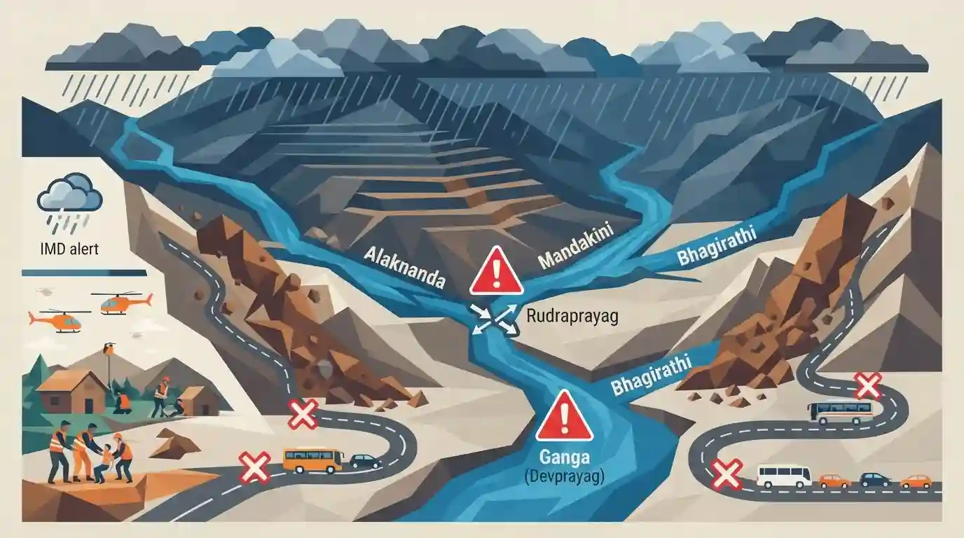
Intense monsoon rainfall in Uttarakhand has caused major rivers like Alaknanda, Mandakini, and Bhagirathi to swell, prompting severe situation alerts from the Central Water Commission at vital confluences like Rudraprayag and Devprayag. The adverse weather, accompanied by IMD alerts, has triggered landslides and road closures, blocking access to major pilgrimage routes such as the Badrinath and Gangotri National Highways.
Key Points
- Major rivers in Uttarakhand, including Alaknanda, Mandakini, and Bhagirathi, are flowing near danger marks due to continuous heavy rainfall.
- The Central Water Commission reported severe conditions at key confluence points like Rudraprayag (Alaknanda and Mandakini) and Devprayag (Alaknanda and Bhagirathi).
- The IMD issued orange and yellow alerts for several districts, warning of heavy to very heavy rainfall.
- Frequent landslides and debris accumulation have forced the closure of critical National Highways leading to the Chardham shrines (Badrinath, Gangotri, Yamunotri).
Important Terms
India Meteorological Department (IMD)

India's primary national meteorological agency, functioning under the Ministry of Earth Sciences. It provides weather forecasting, monsoon tracking, cyclone warnings, and climate services essential for agriculture, disaster management, and aviation.
UPSC context
Crucial for GS Paper 1 (Geography) and GS Paper 3 (Disaster Management). Tests knowledge of monsoon forecasting and early warning systems.
Central Water Commission (CWC)
India's premier technical organization in water resources, operating under the Ministry of Jal Shakti. It handles flood forecasting, dam safety, hydrological observation, and advises the government on water resource management.
UPSC context
Relevant for GS Paper 2 (Statutory/Regulatory Bodies) and GS Paper 3 (Disaster Management). Often tested on flood forecasting mandates.
Alaknanda River
A major Himalayan river originating near the Satopanth Glacier in Uttarakhand. It is one of the two main headstreams of the Ganga and forms the backbone of the sacred 'Panch Prayag' confluences.
UPSC context
Important for GS Paper 1 (Indian Geography/River Systems). UPSC Prelims frequently tests its origin, tributaries, and confluences.
Rudraprayag
A significant geographical and religious site in Uttarakhand marking the confluence of the Alaknanda and Mandakini rivers. It is one of the five sacred river confluences known as the Panch Prayag.
UPSC context
Appears in GS Paper 1 (Geography) and Prelims map-based questions requiring the exact pairing of merging rivers.
Devprayag
A vital confluence town in Uttarakhand where the Alaknanda meets the Bhagirathi river. From this specific point onward, the combined river is officially known as the Ganga.
UPSC context
Highly relevant for GS Paper 1 (Geography). A classic UPSC Prelims trap is confusing which rivers form the Ganga here.
Prelims Trap
"The river Ganga originates from the Gangotri glacier and flows past the Badrinath shrine before entering the plains."
The Bhagirathi originates at Gangotri. It officially becomes the "Ganga" only after merging with the Alaknanda at Devprayag. Furthermore, Badrinath sits on the Alaknanda, not the Ganga.
Static Concepts Connected
What are the key confluences (Panch Prayag) forming the Ganga river system?
- Devprayag: Confluence of Alaknanda and Bhagirathi rivers. The river officially acquires the name 'Ganga' from this point onwards.
- Rudraprayag: Confluence of Alaknanda and Mandakini rivers. The Mandakini originates near the Kedarnath shrine.
- Karnaprayag: Confluence of Alaknanda and Pindar rivers.
- Vishnuprayag: Confluence of Alaknanda and Dhauliganga rivers in the Chamoli district.
What factors make Uttarakhand highly vulnerable to recurrent landslides and flash floods?
- Tectonic instability: The region lies in highly active seismic zones (IV & V) of the young fold Himalayas, resulting in fractured and fragile rock formations.
- Extreme weather events: High-intensity, concentrated monsoon rainfall and cloudbursts rapidly saturate unconsolidated topsoil on steep gradients, triggering mass wasting.
- Anthropogenic disruption: Deforestation, unplanned urbanization, and massive infrastructure projects (like hydropower dams and highway widening) destabilize the natural toe of mountain slopes.
Cross-Topic Patterns
Char Dham Project & Slope Stability
Widening roads for the Char Dham Pariyojana has drawn environmental litigation due to its impact on slope stability, directly linking infrastructure development to monsoon landslide frequency.
Early Warnings & NDMA Protocols
IMD's colour-coded weather warnings directly dictate NDMA and SDMA response protocols, tying technical meteorological forecasting to on-the-ground disaster management operations.

Expect a prelims matching question pairing Himalayan shrines to their respective river banks (e.g., Badrinath-Alaknanda) or the Prayags.
Linked PYQs · 2
Linked PYQs · 2
- 2007UKPSC_PRELIMSGS1
Name the river which flows between Kedarnath | Rudra Prayag?
- 2007UKPSC_PRELIMSGS1
Which of the following Natural Calamity has the most devastating impact in Uttarakhand State?
