Glacial Melt Swells Bhagirathi River Threatening Harsil Settlements
Source:newindianexpress ↗
Why It Matters
Understanding the geography of the Bhagirathi River basin, its tributaries (like Jadganga, Kheer Ganga, and Telgad), and the operational hazards of glacial melt is crucial for UKPSC PCS Prelims. The exam frequently tests local physical geography, river confluences, and regional environmental vulnerabilities.
Summary
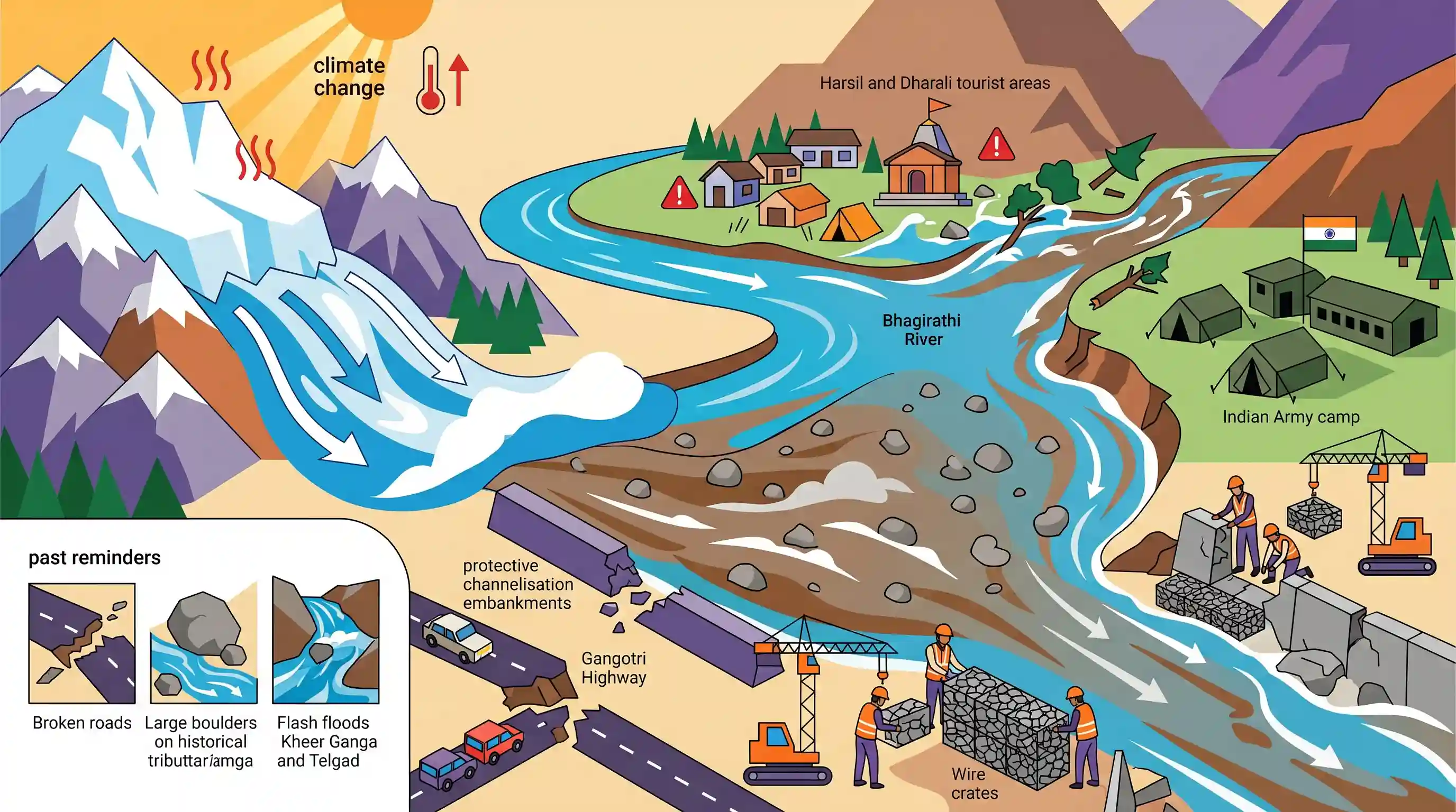
The Bhagirathi River in Uttarakhand's Uttarkashi district has swollen rapidly due to increased glacial melt, threatening tourist areas in Harsil and Dharali, as well as a nearby Indian Army camp. Siltation has elevated the riverbed by six to seven meters, making the river pool like a lake and wash away protective channelisation embankments. The local administration is undertaking urgent protective engineering works, including repair of damaged retaining walls and wire crates, recalling past disastrous flash floods on regional tributaries like the Kheer Ganga and Telgad rivers that historically snapped connectivity on the strategic Gangotri Highway.
Key Points
- Rapid glacial melt has caused the Bhagirathi River to swell, threatening tourist settlements and an Army camp in the Harsil-Dharali stretch of Uttarkashi district.
- Severe siltation has raised the riverbed of the Bhagirathi by 6 to 7 meters in this region, creating a lake-like water body and directing currents toward vulnerable structures.
- The rising water and erosion have damaged protective infrastructure, including wire crates and the concrete retaining wall built to safeguard the GMVN guest house.
- Historically, flash floods in the Kheer Ganga and Telgad rivers (tributaries in the area) have caused heavy casualties and submerged the strategic Gangotri Highway for up to 20 days.
- The state Irrigation Department is executing immediate channelisation work and rebuilding debris embankments to mitigate the risk before the monsoon intensifies.
Important Terms
Bhagirathi River

A major Himalayan river originating from the Gaumukh glacier in Uttarakhand, flowing as a key headstream of the Ganga before merging with the Alaknanda at Devprayag.
UPSC context
GS Paper I (Geography) and GS III (Environment). Tests Himalayan river systems, hydrological patterns, and ecological conservation of the Ganga basin.
Bhagirathi Eco-Sensitive Zone (ESZ)
A protected, ecologically fragile area extending from Gaumukh to Uttarkashi town, notified under the Environment Protection Act, 1986 to safeguard the river's basin and regulate development.
UPSC context
GS Paper III (Environment). Tests understanding of environmental conservation laws, sustainable development, and ecological preservation in fragile mountain terrains.
Garhwal Mandal Vikas Nigam (GMVN)
A public sector undertaking of the Uttarakhand government responsible for promoting tourism, managing local hospitality infrastructure, and facilitating economic development in the Garhwal region.
UPSC context
GS Paper III (State Governance & Infrastructure). Relevance lies in studying state-run PSUs in remote tourism management and local disaster rehabilitation.
Irrigation Department
A state-level administrative body responsible for developing water resources, maintaining canals, and implementing structural engineering measures for flood control and riverbank protection.
UPSC context
GS Paper III (Disaster Management). Tests understanding of institutional roles in flood mitigation, river training, and local hydrological project management.
Gabions (Wire Crates)
Wire mesh cages filled with rocks, concrete, or sand, used as heavy retaining structures to control soil erosion, stabilize steep slopes, and protect riverbanks from high-velocity currents.
UPSC context
GS Paper III (Disaster Management). Tests technical, low-cost structural engineering solutions for landslide mitigation, slope stabilization, and flood hazard management.
Indian Army
The land-based branch of the Indian Armed Forces, which often plays a critical secondary role in conducting Search and Rescue operations during natural disasters in strategic borders.
UPSC context
GS Paper III (Disaster Management & Security). Tests command coordination and assistance provided by armed forces during extreme climatic disasters in border regions.
Prelims Trap
Riverbed aggradation caused by heavy siltation naturally deepens the river channel, thereby reducing the lateral spread of floodwaters during glacial melt.
Aggradation raises the riverbed, making the channel shallower. This forces water to spread laterally, causing severe bank erosion and flooding of adjacent areas rather than deepening the channel.
Static Concepts Connected
What is Riverbed Aggradation and its primary impact on mountainous river basins?
- Definition: The accumulation of sediment and debris in a river channel, which raises the elevation of the riverbed over time.
- Primary Causes: Excessive glacial melt, upstream landslides, and deforestation that supply more sediment than the river flow can transport downstream.
- Hazards Created: It reduces channel volume, forcing water to spill laterally, leading to severe bank erosion, flash floods, and damage to infrastructure.
What are the key confluences (Prayags) and tributaries of the Bhagirathi River system?
- Devprayag Confluence: The Alaknanda and Bhagirathi rivers merge here to officially form the Ganga River, marking the end of the Bhagirathi.
- Bhilangna River: A major tributary originating from the Khatling Glacier, meeting the Bhagirathi at the site of the submerged old Tehri.
- Jadh Ganga: Also known as Jahnavi, this transboundary tributary joins the Bhagirathi at Bhaironghati near the Indo-China border.
Cross-Topic Patterns
Climate Change + Border Security Logistics
Accelerated glacial melt in Uttarakhand directly threatens key arterial roads like the Gangotri Highway and forward military bases, linking ecological degradation to national security vulnerabilities.
Siltation + Hydro-infrastructure Lifespans
Heavy sediment aggradation in the upper reaches of the Bhagirathi increases silt load in reservoirs like Tehri, drastically reducing their operational lifespan and hydropower potential.

Himalayan river aggradation and its impact on strategic border roads (like NH-34) likely to be featured as a GS-3 Disaster Management case study.
Linked PYQs · 3
Linked PYQs · 3
- 2024UKPSC_PRELIMSGS1
Which of the following is a point of confluence of river Jadganga and Bhagirathi ?
- 2025UKPSC_PRELIMSGS1
Which of the following is the correct order of rivers from west to east in Uttarakhand?
- 2021UKPSC_PRELIMSGS1
'Govind National Park' includes :
