IMD issues red alert for heavy rain and flash floods in Himachal
Source:etvbharat ↗
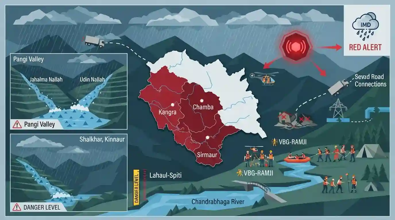
Why It Matters
Understanding the geographical distribution of extreme weather events, vulnerable regions (like Pangi Valley and Lahaul-Spiti), and river basins (Chandrabhaga, Beas) is crucial for HPAS Prelims. It bridges physical geography with environmental disaster awareness, frequently tested in questions mapping state districts, rainfall patterns, and river systems.
Summary
The India Meteorological Department (IMD) has issued a red alert for the Kangra, Chamba, and Sirmaur districts of Himachal Pradesh due to heavy monsoon rains causing flash floods and landslides. Flash floods struck the Pangi Valley (Jahalma and Udin Nallahs) and Shalkhar in Kinnaur, while the Chandrabhaga river surged above danger levels in Lahaul-Spiti. The severe weather has disrupted daily life, damaged infrastructure, severed road connectivity, and disrupted power and drinking water supplies. Rescue and relief operations are ongoing, coordinating the evacuation of individuals, including workers under the VBG-RAMJI scheme. The event underscores the acute vulnerability of Himachal Pradesh's fragile Himalayan geography to extreme monsoonal precipitation and rapid runoff.
Key Points
- The India Meteorological Department (IMD) issued a red alert for extremely heavy rainfall and flash floods in Kangra, Chamba, and Sirmaur districts of Himachal Pradesh.
- Flash floods were triggered by intense monsoon rains in the Pangi Valley (Jahalma and Udin Nallah) of Chamba and Shalkhar village in Kinnaur.
- The Chandrabhaga (Chenab) river crossed the danger mark near the Jobrang bridge in Lahaul-Spiti, highlighting the region's vulnerability to extreme weather events.
- Heavy rains caused severe infrastructure damage, leading to the closure of multiple roads, disruption of power lines, and halting of hundreds of drinking water schemes.
- Rescue operations included evacuating stranded workers covered under the VBG-RAMJI scheme.
Important Terms
VBG-RAMJI Scheme

A rural employment mission (Viksit Bharat Guarantee for Employment and Livelihood Mission-Rural) that empowers panchayats to carry out development and disaster-mitigation works like water conservation, bypassing the mandatory prior self-approval process of MGNREGA.
UPSC context
GS Paper II (Government Schemes) and GS III (Rural Development); tests knowledge of decentralized governance and social safety nets.
India Meteorological Department (IMD)
Established in 1875 under the Ministry of Earth Sciences, the IMD is India's principal agency for meteorological observations, weather forecasting, seismology, and issuing early warnings for natural disasters.
UPSC context
GS Paper I (Climatology) and GS Paper III (Disaster Management); tests understanding of meteorological infrastructure and warning systems.
State Disaster Management Authority (SDMA)
The apex body for disaster management at the state level in India, established under the Disaster Management Act, 2005. It is chaired by the Chief Minister and is responsible for formulating state-specific disaster mitigation policies.
UPSC context
GS Paper III (Disaster Management); tests command over institutional frameworks, hazard mitigation, and center-state disaster relief cooperation.
Chandrabhaga River
A river in Himachal Pradesh formed by the confluence of the Chandra and Bhaga rivers at Tandi, which subsequently forms the Chenab River. It also refers to the Bhima River in Maharashtra near Pandharpur.
UPSC context
GS Paper I (Geography - Indian Drainage Systems); tests physical geography, river courses, tributaries, and regional nomenclature.
IMD Color-Coded Alerts
A weather warning mechanism utilizing four color-codes (Green, Yellow, Orange, Red) to indicate the severity, probability, and risk of upcoming extreme weather events, helping coordinate disaster response and preparedness.
UPSC context
GS Paper III (Disaster Management); tests knowledge of early warning systems, hazard risk mitigation, and climate change response protocols.
Prelims Trap
"The Chenab river originates in the union territory of Jammu and Kashmir."
Chenab (Chandrabhaga) actually originates at Tandi in Lahaul-Spiti (Himachal Pradesh) from the confluence of Chandra and Bhaga rivers, before flowing into J&K.
Static Concepts Connected
What is the geographic profile of the Chandrabhaga (Chenab) river?
- Origin: Formed by the confluence of the Chandra and Bhaga rivers at Tandi in the Lahaul-Spiti district of Himachal Pradesh.
- Course: It flows through the remote Pangi valley, running parallel to the Pir Panjal range, before entering the Jammu region.
What do the IMD colour-coded weather alerts signify?
- Orange Alert: Signifies 'Be Prepared' for heavy to very heavy rainfall (115.6 to 204.4 mm in 24 hours).
- Red Alert: Directs authorities to 'Take Action' anticipating extremely heavy rainfall (exceeding 204.4 mm in 24 hours), implying severe disruption.
Cross-Topic Patterns
Monsoon dynamics & Himalayan vulnerability
Increased Arabian Sea warming is altering moisture transport, leading to short-duration, high-intensity precipitation (cloudbursts) over the fragile Pir Panjal and Dhauladhar ranges.
Micro-climatic zones in geographic mapping
UPSC map questions are shifting from broad states to specific micro-regions. Knowing that Pangi Valley lies between the Zanskar and Pir Panjal ranges is critical.

A 2026 Prelims map question will likely ask to match micro-valleys (Pangi, Lahaul) with their bounding mountain ranges and river basins.
Linked PYQs · 4
Linked PYQs · 4
- 2023HPAS_PRELIMSGS1
Consider the following statements : (1) The rainiest district in Himachal Pradesh is Kangra. (2) Rainfall in the Alpine region of Himachal Pradesh varies between 300-600 mm. (3) Winter season in Himachal Pradesh extends from October to March. (4) Mandi is the hottest place in Himachal Pradesh. Choose the correct answer from the options given below :
- 2022HPAS_PRELIMSGS1
Which of the following statements is correct ? (i) 'Dhauladhar Range' branches off from the Great Himalayan Range near Badrinath (ii) The Pir-Panjal range separates the drainage of the river Spiti from that of the river Beas. (iii) The Zanskar range is the easternmost range which separates Spiti and Kashmir from Tibet. (iv) The 'Gumrang' and 'Sholarang' passes connect the basin of the river Chandrabhaga with its basin in Tibet.
- 2024HPAS_PRELIMSGS1
Arrange the following climatic zones of Himachal Pradesh according to rainfall amount from lowest to highest : (1) Frigid aridic zone (2) Wet temperate zone (3) Humid sub-tropical zone (4) Sub-humid sub-tropical zone Choose the correct answer from the options given below :
- 2025HPAS_PRELIMSGS1
Match List I with List II : | List-I (Code) | List-II (District) | |---|---| | (a) Highest Rainfall (2018 Data) | (i) Shimla | | (b) Second Most Incidents Reported (2024 Crime Data) | (ii) Mandi | | (c) Fourth Highest Population (2011 Census) | (iii) Kangra | | (d) Fourth Largest Area | (iv) Solan | Choose the correct answer from the options given below : Code: (a) (b) (c) (d)
