राजस्थान में अरावली बचाओ आंदोलन और अवैध खनन
स्रोत:इंडियन एक्सप्रेस ↗
क्यों मायने रखता है
The issue provides a real-world case study of the environmental and political consequences of illegal mining. It is highly relevant for GS-3 (Environmental Degradation and Mining Hazards) and GS-1 (Geography, specifically the role of natural barriers in preventing desertification).
सारांश
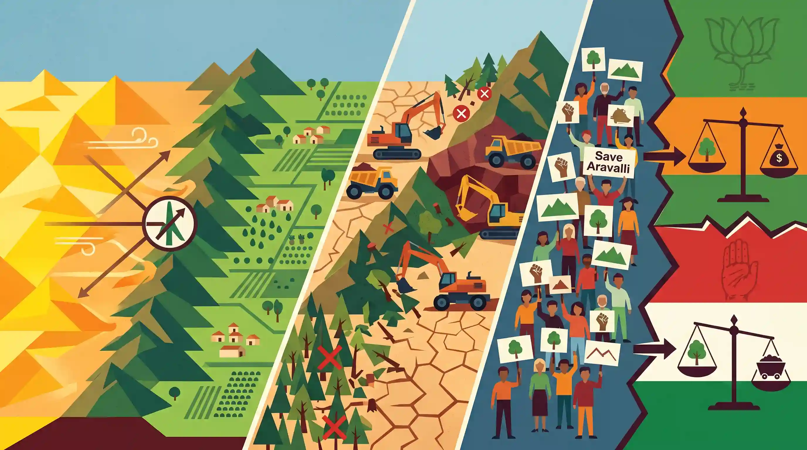
The 'Save Aravalli Hills' protests in Rajasthan have emerged as a significant environmental and political flashpoint, intensifying the rivalry between the BJP and the Congress. The agitation is driven by widespread concern over the ecological destruction of the Aravalli range—the oldest fold mountains in India—due to unchecked illegal mining and deforestation. Because the Aravallis serve as a crucial geographical barrier preventing the eastward expansion of the Thar Desert, their degradation poses severe risks of desertification and climate disruption. Politically, the mobilization is forcing both major parties to navigate complex governance challenges, pitting public demands for conservation against entrenched mining interests.
मुख्य बिंदु
- The 'Save Aravalli Hills' agitation has gained momentum in Rajasthan, highlighting the severe ecological degradation of one of India's oldest mountain ranges.
- Rampant illegal mining and deforestation are the primary threats to the Aravallis, compromising their role as a natural barrier against the eastward expansion of the Thar Desert.
- The environmental protests have evolved into a major political flashpoint, intensifying the blame game between the ruling BJP and the opposition Congress.
- यह मुद्दा पारिस्थितिक संरक्षण के लिए नागरिक समाज की मांगों को संबोधित करने के साथ-साथ शक्तिशाली खनन माफियाओं पर अंकुश लगाने की महत्वपूर्ण शासन संबंधी चुनौती को रेखांकित करता है।
महत्वपूर्ण शब्द
Aravalli Range

भारत की सबसे पुरानी वलित पर्वत प्रणाली जो गुजरात से दिल्ली तक फैली हुई है, जो मरुस्थलीकरण के विरुद्ध एक प्राकृतिक पारिस्थितिक अवरोध के रूप में कार्य करती है और उत्तर भारत के लिए भूजल पुनर्भरण का एक प्राथमिक स्रोत है।
UPSC context
GS पेपर I (भूगोल) और GS III (पर्यावरण)। यह भारतीय भू-आकृति विज्ञान और प्राकृतिक अवरोधों के पारिस्थितिक महत्व के ज्ञान का परीक्षण करता है।
Fold Mountains
Landforms created by the buckling and folding of the Earth's crust due to tectonic plate collisions; categorized as 'young' (Himalayas) or 'old' (Aravallis) based on geological age.
UPSC context
GS Paper I (Physical Geography). Essential for understanding geomorphic processes, plate tectonics, and the distinction between young and old ranges.
Desertification
शुष्क और अर्ध-शुष्क क्षेत्रों में भूमि क्षरण की एक प्रक्रिया, जो जलवायु परिवर्तनों और वनोन्मूलन जैसी मानवीय गतिविधियों के कारण होती है, जिसके परिणामस्वरूप उपजाऊ भूमि अपनी उत्पादकता खो देती है।
UPSC context
GS Paper I and GS III. Relevant to topics on land degradation, UNCCD commitments, and sustainable land management.
थार मरुस्थल
उत्तर-पश्चिमी भारत और पूर्वी पाकिस्तान में स्थित एक विशाल शुष्क क्षेत्र, जिसकी मुख्य विशेषता गतिशील रेत के टीले और अत्यधिक तापमान है, और जो दक्षिण-पूर्व में अरावली पर्वतमाला (Aravalli Range) से घिरा हुआ है।
UPSC context
GS Paper I (Geography). Key for studying Indian climatic zones, desert formation, and the impact of topography on monsoon patterns.
अवैध खनन
बिना कानूनी अनुमति के किया जाने वाला खनिज निष्कर्षण, जिसके कारण अरावली में पहाड़ियों का लुप्त होना, भूजल स्तर में गिरावट और गंभीर पारिस्थितिक क्षरण हुआ है।
UPSC context
GS Paper III (Environment & Governance). Tests understanding of resource governance, judicial interventions (Supreme Court), and environmental impact assessments.
Aravalli Green Wall Project
A multi-state initiative to create a 5-km wide green buffer zone around the Aravalli range to restore degraded land and check the eastward expansion of the Thar Desert.
UPSC context
GS पेपर III (पर्यावरण)। जलवायु परिवर्तन से निपटने और 2030 तक भारत के भूमि क्षरण तटस्थता (land degradation neutrality) लक्ष्यों को पूरा करने की पहलों के लिए महत्वपूर्ण।
प्रारंभिक ट्रैप
"The Aravalli Range is a young fold mountain system confined entirely to the state of Rajasthan."
Aravallis are highly eroded relict (old) fold mountains, not young, and they span four states/UTs—Gujarat, Rajasthan, Haryana, and Delhi.
संबंधित अवधारणाएँ
अरावली पर्वतमाला की भूगर्भीय प्रकृति और भौगोलिक विस्तार क्या है?
- अवशिष्ट पर्वत: They are one of the world's oldest fold mountains, formed in the Precambrian era, now heavily eroded and classified as relict or residual mountains.
- Geographical Extent: यह श्रृंखला गुजरात के पालनपुर से राजस्थान और हरियाणा होते हुए दिल्ली की रायसीना हिल तक लगभग 692 किमी की दूरी में तिरछे रूप में फैली हुई है।
- Highest Peak: राजस्थान के माउंट आबू में स्थित गुरु शिखर (1,722m) इस पर्वत श्रृंखला की सबसे ऊँची चोटी है।
What is the Aravalli Green Wall Project?
- मुख्य उद्देश्य: थार मरुस्थल के पूर्व की ओर विस्तार को रोकने के लिए अरावली पर्वतमाला के साथ 5 किलोमीटर चौड़ा निरंतर वनीकरण बफर (afforestation buffer) बनाने की एक प्रकृति-आधारित नीतिगत पहल।
- अफ्रीकी प्रेरणा: It is directly modeled after the 'Great Green Wall' of Africa in the Sahel region, which aims to combat land degradation and desertification.
- Coverage and Scope: It involves ecological restoration of degraded wastelands across Gujarat, Rajasthan, Haryana, and Delhi, focusing on native tree species and groundwater recharge.
अंतर-विषय पैटर्न
Aravalli degradation and NCR air quality
The destruction of the Aravalli barrier accelerates wind-blown sand transport, directly worsening winter dust pollution and particulate matter (PM10/PM2.5) concentrations in the National Capital Region (NCR).
खनन विनियमन में न्यायिक हस्तक्षेप
The Supreme Court's mandate defining Aravalli landforms and pausing mining leases mirrors its earlier environmental interventions in Goa and Karnataka to curb rampant illegal iron ore mining.

अरावली ग्रीन वॉल प्रोजेक्ट के भौगोलिक कवरेज को UNCCD लक्ष्यों से जोड़ने वाले एक बहु-कथनीय (multi-statement) प्रीलिम्स प्रश्न की अपेक्षा करें।
संबद्ध PYQ · 3
संबद्ध PYQ · 3
- 2025MainsGS3
Mineral resources are fundamental to the country's economy and these are exploited by mining. Why is mining considered an environmental hazard? Explain the remedial measures required to reduce the environmental hazard due to mining.
- 2013MainsGS3
What are the consequences of Illegal mining ? Discuss the Ministry of Environment and Forests' concept of GO AND NO GO zones for coal mining sector.
- 2020MainsGS1
The process of desertification does not have climatic boundaries. Justify with examples.
