Char Dham Pilgrim Footfall Decline Due to Monsoon Disruptions
Source:etvbharat ↗
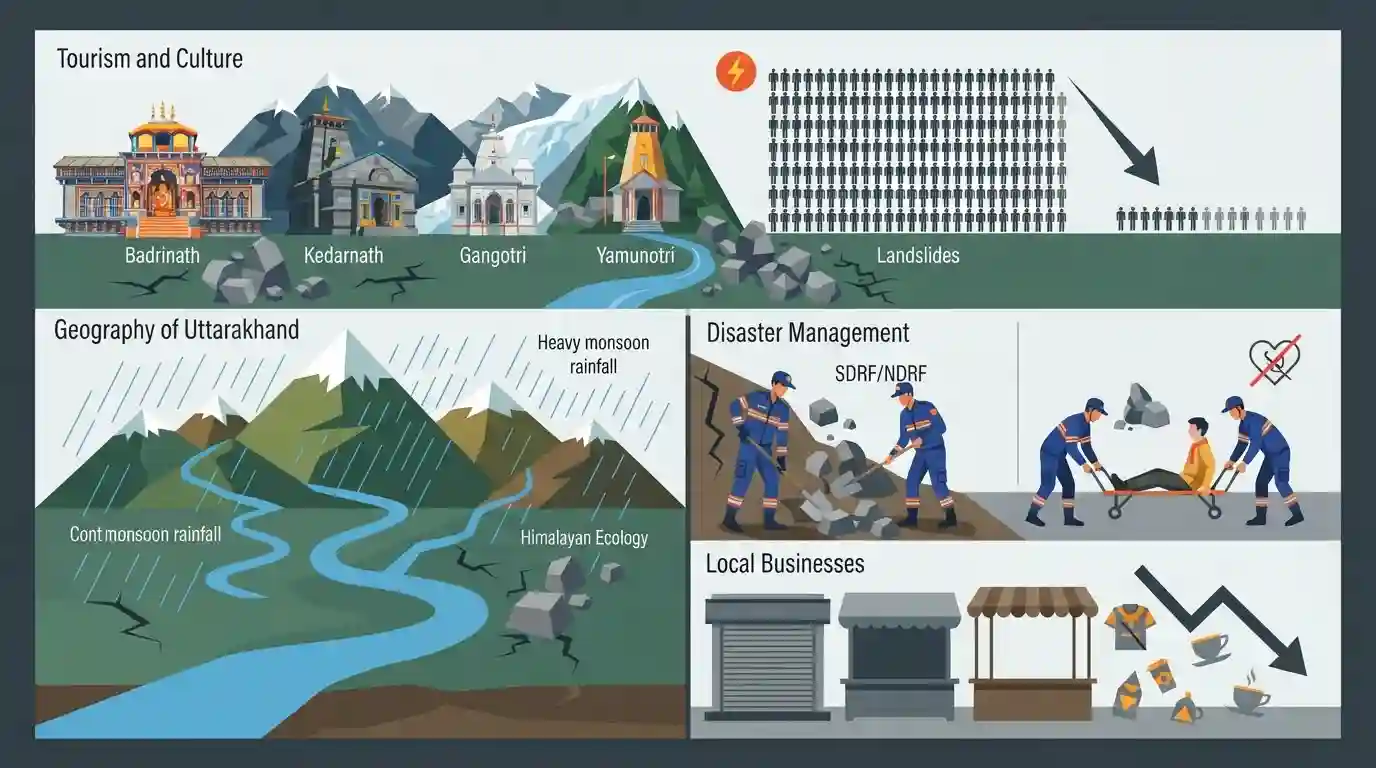
Why It Matters
The Char Dham Yatra is critical to Uttarakhand's economy and culture but exposes the vulnerabilities of the Himalayan ecology to monsoons and landslides. This is highly relevant for UKPSC Prelims Geography and Disaster Management sections, testing knowledge of pilgrim shrines, terrain, and state-level disaster response mechanisms.
Summary
The annual Char Dham Yatra in Uttarakhand has seen a drastic decline in pilgrim numbers, plunging from 60,000 daily visitors to around 1,500 due to continuous monsoon rainfall and frequent landslides. Despite the weather disruptions, the yatra has attracted over 45 lakh devotees this year across the Badrinath, Kedarnath, Gangotri, and Yamunotri shrines. High altitude and underlying health conditions have led to 210 pilgrim deaths, mostly from heart attacks. The state has heavily deployed disaster management forces like the SDRF and NDRF to handle emergencies and clear routes, while local businesses face economic setbacks from the reduced footfall.
Key Points
- Daily pilgrim footfall for the Char Dham Yatra dropped drastically from nearly 60,000 to roughly 1,500 due to continuous monsoon rains and landslides.
- Despite the current drop, over 45 lakh devotees have visited the shrines (Badrinath, Kedarnath, Gangotri, and Yamunotri) so far this year.
- There have been 210 pilgrim deaths recorded, predominantly attributed to health issues like heart attacks exacerbated by the high altitude.
- Disaster management forces, including NDRF and SDRF, are actively deployed in landslide-prone and sensitive areas to ensure pilgrim safety and clear blocked routes.
Important Terms
Char Dham Yatra

A sacred Hindu pilgrimage circuit in Uttarakhand's Garhwal Himalayas comprising four high-altitude shrines: Yamunotri, Gangotri, Kedarnath, and Badrinath.
UPSC context
Relevant to GS Paper 1 (Indian Culture and Geography). Highlights the intersection of religious tourism and Himalayan ecology.
NDRF
The National Disaster Response Force is a specialized central unit raised under the Disaster Management Act, 2005, for swift response to natural and man-made disasters.
UPSC context
Key to GS Paper 3 (Disaster Management). Tests understanding of India's statutory emergency response and rescue framework.
SDRF
State Disaster Response Forces are specialized, state-level units providing localized and immediate rescue operations during natural and man-made disasters.
UPSC context
Important for GS Paper 3 (Disaster Management). Showcases the decentralized, state-level execution of India's disaster response architecture.
Badrinath-Kedarnath Temple Committee
A statutory body responsible for the administration and management of the Badrinath and Kedarnath temples, along with several other shrines in Uttarakhand.
UPSC context
Relevant to GS Paper 2 (Governance). Illustrates the role of statutory bodies in managing major religious and cultural institutions.
Prelims Trap
"The Kedarnath shrine is situated on the banks of the Alaknanda river."
Kedarnath is located on the Mandakini river, while Badrinath sits on the Alaknanda. UPSC frequently swaps these exact tributaries of the Ganga system to test map precision.
Static Concepts Connected
Which river valleys host the four Chota Char Dham shrines?
- Badrinath: Situated on the banks of the Alaknanda River.
- Kedarnath: Located in the Mandakini River valley.
- Gangotri: Situated on the banks of the Bhagirathi River.
- Yamunotri: Located near the source of the Yamuna River.
Why are the Himalayas uniquely susceptible to landslides?
- Tectonic Instability: Active tectonic convergence makes the region seismically active, destabilizing slopes.
- Geological Youth: Composed of relatively young, unconsolidated sedimentary and metamorphic rocks.
- Anthropogenic Pressure: Road widening for tourism and unscientific terracing steepen already critical natural gradients.
Cross-Topic Patterns
Carrying Capacity & Ecotourism Policy
The massive influx of 45 lakh pilgrims directly links to the Supreme Court's push for evaluating the 'carrying capacity' of Himalayan hill stations to prevent Joshimath-like subsidence.
High-Altitude Hypoxia & General Science
The high pilgrim mortality rate links geography (low atmospheric pressure) with biology (Acute Mountain Sickness), a recurring theme in General Science questions on human physiological adaptation.
Pilgrimage Zones & Protected Areas
Infrastructure expansion for shrines often fragments crucial habitats, such as the Kedarnath Wildlife Sanctuary, testing the balance between religious tourism and Himalayan Musk Deer conservation.

Himalayan carrying capacity + river mapping (Mandakini/Alaknanda) + disaster vulnerability likely forms a composite 2026 Prelims MCQ.
Linked PYQs · 1
Linked PYQs · 1
- 2016UKPSC_PRELIMSGS1
Which one of the following shrines of Uttarakhand was visited by maximum number of tourists in the year 2015?
