Char Dham Yatra Suspension Amid Heavy Rains and Landslides
Source:newindianexpress ↗
Why It Matters
The frequent suspension of the Char Dham Yatra due to landslides and flash floods is a stark reminder of Uttarakhand's ecological fragility. For UKPSC aspirants, this underscores the importance of the state's drainage system (e.g., Alaknanda, Mandakini), geography, and the pressing need for robust disaster management strategies in the face of climate-induced extreme weather events.
Summary
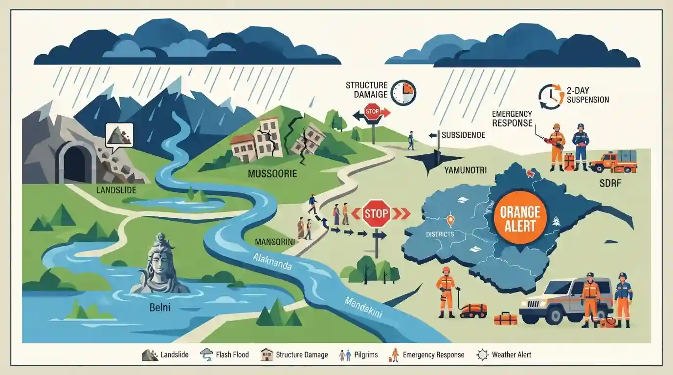
Heavy rains in Uttarakhand have prompted the state government to suspend the Char Dham Yatra for two days amid severe landslides and a flash flood alert issued by the IMD. An 'orange alert' is in effect for nine districts. The swelling Alaknanda and Mandakini rivers have submerged low-lying areas, including the Lord Shiva statue at Belni. Landslides have caused structural damage in Mussoorie and near tunnels in Rudraprayag, alongside subsidence on the Yamunotri pedestrian route. The SDRF is on high alert, underscoring the severe ecological vulnerability of the Himalayan region to extreme weather events.
Key Points
- The Uttarakhand government suspended the Char Dham Yatra for two days due to relentless heavy rainfall, severe landslides, and an IMD flash flood alert across the state.
- The IMD issued an 'orange alert' for nine districts and a 'yellow alert' for four others, warning of extremely heavy rainfall and potential localized flooding.
- The Alaknanda and Mandakini rivers are in spate; the rising waters submerged the Lord Shiva statue at Belni, highlighting the vulnerability of riverine infrastructure.
- Major infrastructural damage was reported, including a landslide near a tunnel in Rudraprayag, a collapsed restaurant in Mussoorie, and road subsidence on the Jankichatti-Yamunotri pedestrian route.
- The State Disaster Response Force (SDRF) and local disaster management teams have been put on high alert to mitigate the impact of these extreme hydro-meteorological events on pilgrims and residents.
Important Terms
Char Dham Yatra

A sacred Hindu pilgrimage circuit in Uttarakhand's Himalayas, comprising four holy shrines—Yamunotri, Gangotri, Kedarnath, and Badrinath—revered for spiritual liberation (moksha) and deeply tied to the region's cultural heritage.
UPSC context
GS Paper I (Indian Culture) and GS Paper III (Disaster Management; ecological vulnerability and climate-induced tourism management in fragile ecosystems).
India Meteorological Department (IMD)
India's apex national meteorological service under the Ministry of Earth Sciences, responsible for weather forecasting, climate monitoring, and issuing colour-coded early warnings for severe weather events.
UPSC context
GS Paper III (Disaster Management), testing early warning systems, weather hazard mitigation, and color-coded alert protocols (Green, Yellow, Orange, Red).
State Disaster Response Force (SDRF)
A state-level specialized response force trained in rescue and relief operations during natural or human-made disasters, acting as the immediate ground-level responder in close coordination with district authorities.
UPSC context
GS Paper III (Disaster Management), testing state-level institutional frameworks, rapid rescue operations, and ground-level disaster mitigation.
District Disaster Management Authority (DDMA)
A statutory district-level body established under Section 25 of the Disaster Management Act, 2005, chaired by the District Magistrate, responsible for planning, coordinating, and implementing disaster management and mitigation measures.
UPSC context
GS Paper III (Disaster Management), testing local institutional framework, decentralised disaster response, and community-level preparedness.
Prelims Trap
"The Mandakini and Alaknanda rivers merge at Devprayag to formally form the river Ganga."
Aspirants frequently mix up the Panch Prayag. Mandakini meets Alaknanda at Rudraprayag. It is the Bhagirathi that meets Alaknanda at Devprayag to form the Ganga.
Static Concepts Connected
What are the Panch Prayag confluences along the Alaknanda river?
- Vishnu & Nanda: Alaknanda meets the Dhauliganga at Vishnuprayag, and the Nandakini river at Nandaprayag.
- Karna & Rudra: Alaknanda merges with the Pindar river at Karnaprayag, and the Mandakini river at Rudraprayag.
- Devprayag: Alaknanda finally merges with the Bhagirathi river at this confluence to formally become the Ganga.
What do the IMD's colour-coded weather warnings signify?
- Yellow Alert: Advises the public to 'Be Aware' and keep updated regarding potentially bad weather conditions.
- Orange Alert: A directive to 'Be Prepared' for extremely bad weather that could cause power and transport disruptions.
- Red Alert: Requires authorities and public to 'Take Action' against extreme weather posing significant risk to life.
Cross-Topic Patterns
Himalayan Geology + Infrastructure Push
Flash floods and landslides constantly trigger debates on the 'carrying capacity' of the fragile, young Himalayan ecosystem against heavy infrastructural pushes like the Char Dham project.
Riverine Geography + Tectonic Convergence
The vulnerability of the Mandakini and Alaknanda valleys is inherently tied to the active tectonic convergence of the Indian and Eurasian plates, making it a disaster hotspot.

Expect a matched-pair Prelims question on the Panch Prayag confluences, or a Mains question on Himalayan carrying capacity.
Linked PYQs · 3
Linked PYQs · 3
- 2025UKPSC_PRELIMSGS1
Which of the following is the correct order of rivers from west to east in Uttarakhand?
- 2025UKPSC_PRELIMSGS1
Consider the following statements and select the correct answer from the options given below : Statement 1 : Uttarakhand is highly vulnerable to climate change. Statement 2 : Climate change is causing water stress and depleting biodiversity in Uttarakhand.
- 2012UKPSC_PRELIMSGS1
Which are called 'Duns' in Uttarakhand?
