Himachal Monsoon Disruption and Landslide Impact
Source:theprint ↗
Why It Matters
This event underscores the high vulnerability of the Himalayan region to monsoon-induced disasters like landslides and flash floods. It is highly relevant for HPAS Prelims regarding questions on the state's rainfall distribution, climatic zones (e.g., Dharamshala/Kangra receiving high rainfall), and the socio-economic impacts of natural disasters.
Summary
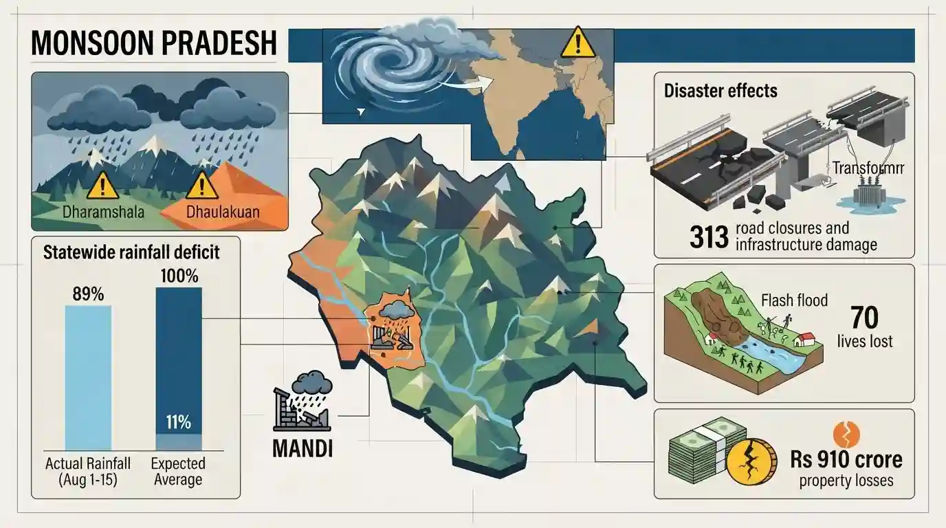
Heavy monsoon rains in Himachal Pradesh triggered widespread infrastructure disruptions, leading to the closure of 313 roads and affecting numerous water supply schemes and transformers. According to the State Emergency Operation Centre, Mandi was the worst-hit district. Although regions like Dhaulakuan and Dharamshala received high localized rainfall, the state overall recorded an 11% rain deficit in the first half of August. The ongoing monsoon season has been devastating, claiming 70 lives due to landslides and flash floods, and causing an estimated Rs 910 crore in property losses.
Key Points
- Widespread monsoon rains in Himachal Pradesh led to the closure of 313 roads, 65 water supply schemes, and affected 112 transformers.
- Mandi district was the worst affected with 117 road closures, followed by Shimla, Chamba, and Kullu.
- Dhaulakuan recorded the highest rainfall (80.5 mm), with other high precipitation areas including Dharamshala and Palampur.
- Despite intense localized downpours, the state experienced an 11% overall rainfall deficit between August 1 and August 12.
- Since the monsoon onset on June 30, natural disasters like landslides and flash floods have caused 70 fatalities and property losses estimated at Rs 910 crore.
Important Terms
State Emergency Operation Centre

A state-level coordination hub under the State Disaster Management Authority (SDMA). It monitors disaster situations, disseminates early warnings, and coordinates emergency response and relief operations across districts during crises.
UPSC context
GS 3 (Disaster Management). Tests understanding of the institutional framework and coordination mechanisms under the Disaster Management Act, 2005.
India Meteorological Department
India's national meteorological agency under the Ministry of Earth Sciences. It provides crucial weather forecasting, climate services, and early warnings for natural hazards like heavy rainfall and cyclones.
UPSC context
GS 1 & 3. Tests knowledge of monsoon dynamics, early warning systems, and the role of scientific agencies in disaster preparedness.
Flash Floods
Highly localized, sudden flooding events that occur within six hours of intense rainfall or water release. They feature a rapid rise in water levels and are highly destructive.
UPSC context
GS 1 & 3. Highlights extreme weather events driven by climate change and the disaster vulnerability of hilly terrains.
Landslides
The rapid downward mass movement of rock, earth, or debris down a slope. In the Himalayas, they are frequently triggered by heavy monsoon rains, deforestation, and unscientific infrastructure development.
UPSC context
GS 1 & 3. Focuses on geomorphic hazards, ecological fragility of mountainous regions, and structural mitigation measures like hazard zonation.
Prelims Trap
Himalayan landslides and flash floods are always preceded by state-wide excess monsoon rainfall.
Severe landslides and flash floods often result from extreme localized precipitation (like cloudbursts), even during an overall state rainfall deficit.
Static Concepts Connected
What is the IMD definition of a Cloudburst?
- Rainfall Rate: Unexpected precipitation exceeding 100 mm per hour.
- Geographical Area: Occurs over a geographical region of approximately 20-30 square kilometers.
- Topography: Most common in mountainous regions due to rapid orographic lift of moisture-laden winds.
Why are Himalayas more prone to landslides than Western Ghats?
- Geological Age: Himalayas are young, tectonically active fold mountains with highly fragmented and unstable sedimentary rocks.
- Topography: Himalayas have much steeper slopes compared to the older, more highly eroded block mountains of the Ghats.
- Triggers: High seismicity coupled with intense monsoonal downpours and anthropogenic activities (e.g., rapid road widening).
Cross-Topic Patterns
Deficits vs. Extreme Weather
Rising occurrences of extreme localized precipitation leading to flash floods, despite overall seasonal rainfall deficits, highlight climate change impacts on India's monsoon patterns.
Infrastructure + Sendai Framework
The destruction of hill roads and transformers underscores the need for DRI, linking local Himalayan governance to the Sendai Framework and India's Coalition for Disaster Resilient Infrastructure (CDRI).

Expect a GS3 question linking Himalayan carrying capacity to infrastructure loss, or a Prelims MCQ comparing Himalayan vs Ghats landslides.
Linked PYQs · 3
Linked PYQs · 3
- 2024HPAS_PRELIMSGS1
Arrange the following climatic zones of Himachal Pradesh according to rainfall amount from lowest to highest : (1) Frigid aridic zone (2) Wet temperate zone (3) Humid sub-tropical zone (4) Sub-humid sub-tropical zone Choose the correct answer from the options given below :
- 2023HPAS_PRELIMSGS1
Consider the following statements : (1) The rainiest district in Himachal Pradesh is Kangra. (2) Rainfall in the Alpine region of Himachal Pradesh varies between 300-600 mm. (3) Winter season in Himachal Pradesh extends from October to March. (4) Mandi is the hottest place in Himachal Pradesh. Choose the correct answer from the options given below :
- 2025HPAS_PRELIMSGS1
When was the National Centre for Disaster Management established in India ?
