Bhor Ghat Railway Section: Access Road Planned for Monsoon Rescues
Source:urban-acres ↗
Why It Matters
MPSC Combined Prelims heavily tests the geography of Maharashtra, particularly the Sahyadri (Western Ghats) passes, transport networks, and state infrastructure projects. The Bhor Ghat is a historically and economically vital pass connecting Mumbai and Pune, making its disaster-resilience and transport planning highly relevant for candidates.
Summary
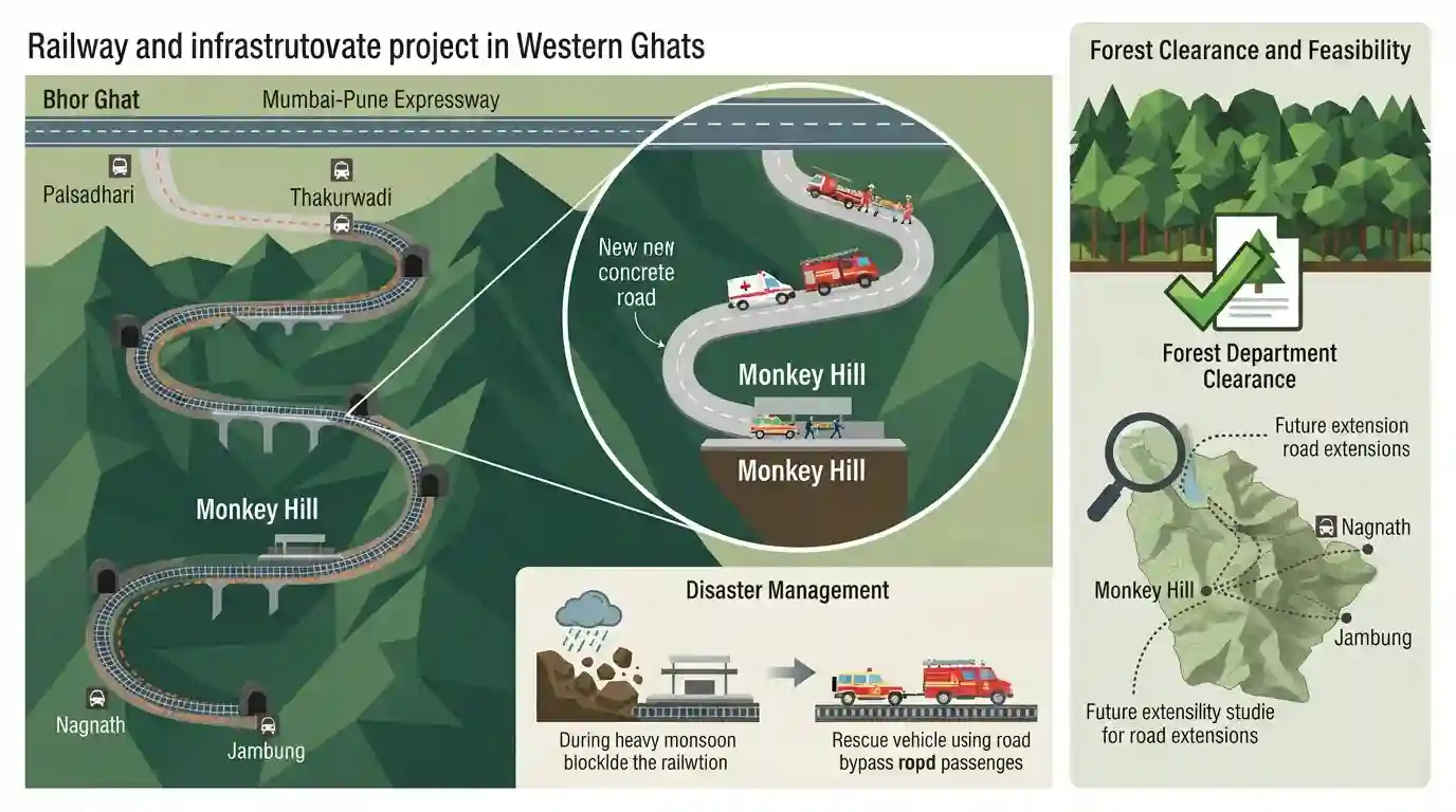
The railway administration is planning a 1.5-km concrete access road, estimated at ₹1.5–2 crore, to connect the remote Monkey Hill railway station on the Bhor Ghat section (between Palsadhari and Khandala) to the Mumbai-Pune Expressway. Currently, the railway tracks are the only access route to several isolated stations in this landslide-prone, 19–20 km stretch, including Monkey Hill, Thakurwadi, Nagnath, and Jambung. The new road will enable emergency vehicles, ambulances, and rescue teams to reach the corridor quickly during monsoon disruptions. The project is awaiting Forest Department clearance, and feasibility studies are underway to potentially extend road access to other isolated stations in the ghat.
Key Points
- A 1.5-km concrete access road is planned to connect the remote Monkey Hill railway station in the Bhor Ghat to the Khandala-bound carriageway of the Mumbai–Pune Expressway.
- The project aims to improve emergency access, disaster response, and monsoon landslide rescue operations in a terrain that currently relies solely on railway tracks for access.
- Monkey Hill is part of a vulnerable 19-20 km stretch of the Bhor Ghat section (between Palsadhari and Khandala) which also hosts other isolated stations like Thakurwadi, Nagnath, and Jambung.
- The project is estimated to cost ₹1.5–2 crore and requires critical forest clearance from the Forest Department as the alignment lies in a ecologically sensitive area of the Western Ghats.
- Central Railway is conducting technical mapping and feasibility studies to assess if similar road connectivity can be extended to other isolated stations in the ghat.
Important Terms
Bhor Ghat

A major mountain pass in the Sahyadri range of Maharashtra, historically significant for trade, connecting Mumbai/Konkan coastal plains to the Deccan Plateau (Pune).
UPSC context
MPSC GS Paper I (Geography). Tests physical features, major passes, and trade routes of Maharashtra.
Central Railway
One of the key zones of Indian Railways, headquartered at Chhatrapati Shivaji Maharaj Terminus (CSMT) in Mumbai, administering transport networks across Maharashtra.
UPSC context
MPSC GS Paper I & IV (Geography & Economy). Tests transport infrastructure and regional development.
Forest Conservation Act, 1980
A crucial central legislation enacted to control deforestation in India by regulating the diversion of forestland for non-forestry purposes, requiring prior central government clearance.
UPSC context
MPSC GS Paper I & IV (Environment & Development). Tests environmental legislation and clearance procedures for infrastructure.
Mumbai-Pune Expressway
India's first six-lane concrete high-speed toll road, stretching 93 km to connect Mumbai and Pune, cutting through the Sahyadri range to facilitate rapid transit.
UPSC context
MPSC GS Paper I & IV (Geography & Economy). Tests regional physical geography and key infrastructure projects in Maharashtra.
Prelims Trap
The Bhor Ghat railway route and the road route share identical terminal points between Khopoli and Khandala.
MPSC candidates often overlook that Bhor Ghat's rail route starts at Palasdari (Karjat), whereas the road route starts at Khopoli, though both terminate near Khandala.
Static Concepts Connected
What are the key geographical and structural features of the Bhor Ghat?
- Route Terminals: Connects Konkan to Deccan. Railway line runs from Palasdari to Khandala; road route runs from Khopoli to Khandala.
- Catch Siding: Specialized safety tracks on steep gradients, like at Monkey Hill, designed to decelerate runaway descending trains safely.
- Vulnerable Topography: Highly landslide-prone basaltic cliffs of the Sahyadri range, demanding intensive monsoon disaster mitigation.
How are forest clearances regulated for developmental projects in Maharashtra's ESAs?
- FCA Mandate: The Forest (Conservation) Act, 1980 mandates central/state forest clearances for diverting forest land to non-forest infrastructure purposes.
- Eco-Sensitive Zones: Bhor Ghat falls in Western Ghats Ecologically Sensitive Areas, requiring strict environmental impact assessments under MoEFCC guidelines.
- Dual Jurisdiction: Projects in this corridor cross boundaries of both Pune and Alibag Forest Divisions, requiring dual administrative approvals.
Cross-Topic Patterns
Sahyadri landslides + Disaster mitigation
Structural mitigation projects in Bhor Ghat (like concrete access roads) align directly with SDMA's landslide risk reduction strategies across the highly vulnerable Sahyadri range.
Infrastructure + Western Ghats Conservation
Infrastructure expansion in Bhor Ghat (e.g., Expressway Missing Link) highlights the continuous tension between infrastructure growth and Western Ghats Eco-Sensitive Area (ESA) preservation.

Multi-statement questions on Maharashtra geography testing Bhor Ghat's exact transit terminals and landslide-prone railway stations.
Linked PYQs · 3
Linked PYQs · 3
- 2025MPSC_PRELIMSGS1
Kalsubai is the highest mountain peak in Maharashtra located in which of the following mountain ranges ?
- 2023MPSC_PRELIMSGS1
Which of the following is/are correct statements ? In Maharashtra, in order from north, the major hill ranges on the plateau and the river basins to their south are as follows : a. Tapi Purna basin to the south of the Satpura mountain range. b. Godavari river valley to the south of Satmala Ajintha hills. c. Harishchandra Balaghat hill and Bhima river basin to its south. d. Shambhu Mahadeva hills and Krishna river basin to its south.
- 2025MPSC_PRELIMSGS1
Identify the correct statements regarding Bhagwan Birsa Munda Road Linking Scheme. A. This scheme was started by Maharashtra Government. B. This scheme was only launched to connect the tribal villages. C. This scheme was made to connect tribal areas with primary health centres and Ashram schools through main roads. D. This scheme was discontinued by Govt. of Maharashtra in January 2025.
