NISAR earth observation satellite final science operations phase
Source:The Hindu ↗
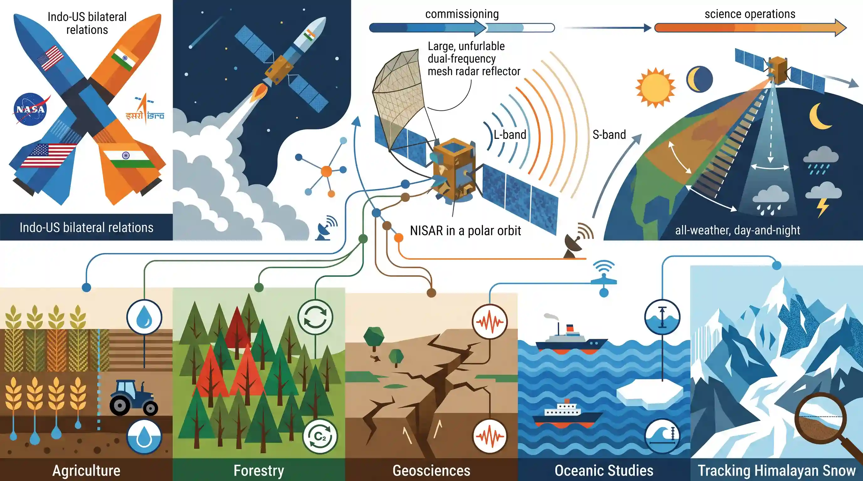
Why It Matters
NISAR is a prime example of an international space collaboration with tremendous socio-economic benefits. For UPSC, it represents the intersection of space technology and practical applications (like agricultural monitoring, disaster management, and climate change tracking), which are frequently tested in GS3.
Summary
The NASA-ISRO Synthetic Aperture Radar (NISAR) satellite has transitioned into its final science operations phase following its launch. This landmark Earth observation satellite, jointly developed by India and the U.S., utilizes advanced radar technology to provide continuous, all-weather, day-and-night data. The high-resolution observations will support critical applications in agriculture, forestry, geosciences, oceanic studies, and tracking Himalayan snow, showcasing the vast potential of space technology for terrestrial problem-solving and environmental monitoring.
Key Points
- The NISAR (NASA-ISRO Synthetic Aperture Radar) satellite has successfully entered its final science operations phase after its launch in July.
- NISAR is a collaborative Earth observation satellite developed jointly by India\'s ISRO and the U.S.\'s NASA.
- The satellite provides all-weather, day-and-night mapping data utilizing Synthetic Aperture Radar (SAR) technology.
- Its high-resolution imagery will be utilized across diverse scientific and practical domains, including agriculture, forestry, geosciences, Himalayan snow monitoring, and oceanic studies.
- The current phase involves maintaining the science orbit via regular manoeuvres and undertaking extensive calibration and validation activities.
Important Terms
NISAR

A joint NASA-ISRO Earth-observation mission utilizing dual-frequency radar to map the entire globe every 12 days, monitoring surface changes, hazards, and climate impacts.
UPSC context
GS Paper 3 (S&T); crucial for topics on international collaborations and satellite applications in disaster management.
Synthetic Aperture Radar (SAR)
An active remote sensing technology that uses microwave pulses to create high-resolution 2D or 3D images of Earth's surface, independent of sunlight or weather conditions.
UPSC context
GS Paper 3 (S&T); tests technical understanding of remote sensing and its advantages over optical imaging.
ISRO
India's national space agency responsible for the NISAR satellite bus, S-band radar, launch services, and ground operations for the joint mission.
UPSC context
GS Paper 3 (S&T); covers institutional achievements and India's growing role in global space governance.
NASA
The US space agency providing the L-band SAR, high-rate communication subsystem, and GPS receivers for the NISAR mission.
UPSC context
GS Paper 2 (International Relations); significant for Indo-US bilateral S&T cooperation and strategic partnerships.
L-band and S-band
Specific microwave frequencies used in NISAR; L-band (NASA) penetrates thick vegetation/ice, while S-band (ISRO) is optimized for surface-level features like crops and wetlands.
UPSC context
GS Paper 3 (S&T); tests knowledge of the electromagnetic spectrum and its specific applications in Earth observation.
GSLV Mark II
India's three-stage heavy-lift launch vehicle used to place NISAR into a Sun-synchronous polar orbit, marking its first such mission.
UPSC context
GS Paper 3 (S&T); covers launch vehicle technology and ISRO's diversifying orbital capabilities.
Earth Observation Satellite (EOS)
Spacecraft designed to monitor Earth's physical, chemical, and biological systems; NISAR is a state-of-the-art EOS for environmental and hazard monitoring.
UPSC context
GS Paper 3 (Environment & S&T); relevant for climate change mitigation and natural resource management.
Prelims Trap
"In the NISAR mission, ISRO developed the L-band radar while NASA developed the S-band radar."
UPSC frequently swaps contributions in joint missions. NASA provided the L-band radar (longer wavelength), while ISRO provided the S-band radar (shorter wavelength).
Static Concepts Connected
What makes Synthetic Aperture Radar (SAR) superior to traditional optical remote sensing?
- Active System: Unlike optical sensors that rely on reflected sunlight, SAR is an active system that emits its own microwave pulses to illuminate the target.
- All-Weather Capability: Microwave wavelengths penetrate clouds, fog, and darkness, enabling uninterrupted 24/7 Earth imaging regardless of atmospheric conditions.
- Virtual Antenna: It uses the satellite's forward orbital motion to mathematically synthesize a much larger antenna, yielding highly detailed, high-resolution imagery.
How do L-band and S-band radar frequencies differ in Earth observation?
- L-Band (NASA): Operates at a longer wavelength (~24 cm), allowing it to penetrate dense forest canopies to measure underlying soil moisture and woody biomass.
- S-Band (ISRO): Operates at a shorter wavelength (~9 cm), which interacts more heavily with lighter vegetation, crop structures, and coastal ocean dynamics.
Cross-Topic Patterns
NISAR & Himalayan GLOF Risk
NISAR's continuous cryosphere tracking links directly to GS-3 Disaster Management by measuring glacier deformation, providing critical early-warning data for Himalayan Glacial Lake Outburst Floods (GLOFs).
Space Tech in Precision Agriculture
Space technology acts as an 'e-technology' for farmers (GS-3). NISAR's all-weather soil moisture and crop cycle mapping will be vital for precision agriculture and drought management.

NISAR's L/S-band payload division, active vs passive radar traits, and utility in GLOF monitoring are prime targets for a 2026 question.
Linked PYQs · 3
Linked PYQs · 3
- 2024PrelimsGS1
Consider the following activities : 1. Identification of narcotics on passengers at airports or in aircraft 2. Monitoring of precipitation 3. Tracking the migration of animals In how many of the above activities can the radars be used?
- 2020MainsGS3
How is science interwoven deeply with our lives? What are the striking changes in agriculture triggered off by the science-based technologies?
- 2023MainsGS3
How does e-Technology help farmers in production and marketing of agricultural produce? Explain it.
