Himalayan Seismic Vulnerability and Urban Infrastructure Risks
Source:The Hindu ↗
কেন এটি গুরুত্বপূর্ণ
This article remains highly relevant as the Himalayan region continues to face compounding disasters (such as the Joshimath land subsidence in 2023 and frequent seismicity in North India). It addresses the core GS3 syllabus topic of disaster management, illustrating the critical nexus between infrastructure development, physical geography, and institutional preparedness.
সারসংক্ষেপ
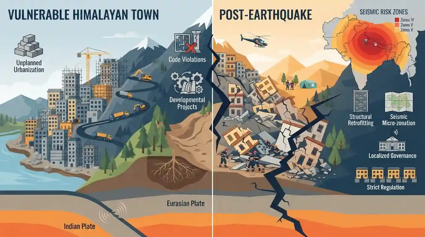
Following the devastating 2015 Nepal earthquake, this article serves as a stark warning to India about the extreme vulnerability of its own Himalayan region. It highlights how natural geological processes (plate tectonics) turn into catastrophic human disasters due to unplanned urbanization, flouting of seismic building codes, and aggressive developmental projects in fragile terrains. The author advocates for strict regulation of construction, seismic micro-zonation, structural retrofitting, and localized disaster risk governance.
মূল বিষয়
- Tectonic Underpinnings: The continuous subduction of the Indian Plate beneath the Eurasian Plate stores massive elastic strain along the Himalayan arc, making the entire region highly susceptible to severe, high-magnitude earthquakes.
- Man-Made Disaster Amplifiers: Rapid and unregulated urbanization has led to the proliferation of multi-story concrete structures on unstable mountain slopes, ignoring seismic-resistant engineering and traditional building styles.
- Aggressive Developmental Interventions: Large infrastructure projects, such as mega-hydropower dams and heavy highway cutting, weaken the fragile geology of the Himalayas, exacerbating landslide risk and slope failure during seismic events.
- Seismic Risk Governance: There is a critical lack of strict enforcement of seismic building codes (specifically Bureau of Indian Standards guidelines such as IS 1893) by municipal bodies in high-risk zones (Seismic Zones IV and V).
- Proactive Mitigation Framework: India must shift from reactive disaster response to proactive risk reduction, including high-resolution seismic micro-zonation, mandatory retrofitting of public structures, and community-led disaster preparedness.
গুরুত্বপূর্ণ শব্দ
National Disaster Management Act 2005

The primary legislative framework in India for managing disasters, establishing a three-tier institutional structure (national, state, district) to shift the national focus from reactive relief to proactive disaster preparedness and mitigation.
UPSC context
GS Paper III (Disaster Management). Tests legal frameworks, institutional mandates, and the shift from relief-centric to prevention-focused disaster strategies.
National Disaster Management Authority (NDMA)
The apex statutory body in India for disaster management, headed by the Prime Minister, responsible for framing national policies, plans, and guidelines to ensure timely and effective response to disasters.
UPSC context
GS Paper III (Disaster Management). Tests the role, institutional hierarchy, and initiatives of the apex body in mitigating and responding to natural hazards.
National Building Code of India
A comprehensive model code published by the Bureau of Indian Standards, providing guidelines for regulating building construction, structural safety, fire safety, and disaster resilience across the country.
UPSC context
GS Paper III (Disaster Management/Urbanization). Tests knowledge of structural safety standards and code enforcement in building disaster-resilient urban infrastructure.
Bureau of Indian Standards (BIS)
The National Standards Body of India under the Ministry of Consumer Affairs, Food and Public Distribution, responsible for standardization, product certification (like the ISI mark), and formulating codes including national building guidelines.
UPSC context
GS Paper III (Indian Economy/Infrastructure). Tests regulatory bodies, quality standards, and their application to safety codes in structural engineering and manufacturing.
Seismic Microzonation
The process of dividing a geographic area (usually a city) into smaller zones based on site-specific geological and geotechnical conditions to assess local variations in earthquake hazard and guide resilient urban planning.
UPSC context
GS Paper I/III (Geography/Disaster Management). Tests localized hazard mapping, earthquake preparedness, and site-specific risk mitigation in rapidly urbanizing regions.
Seismic Zones of India
The classification of India's landmass into distinct zones (Zones II to V) based on seismicity and historical earthquake damage risk, mapped by the Bureau of Indian Standards to regulate engineering design.
UPSC context
GS Paper I/III (Physical Geography/Disaster Management). Tests geographical distribution of tectonic risks, seismic vulnerability mapping, and earthquake design code enforcement.
প্রিলিমস ফাঁদ
India is classified into five active seismic zones (Zones I to V) or has implemented the six-zone classification including Zone VI.
Zone I does not exist (merged into Zone II). The proposed 2025 revision creating Zone VI was withdrawn in early 2026, keeping only four active zones (II to V).
সংযুক্ত স্থির ধারণা
How do Himalayan and Western Ghats landslides differ geologically and trigger-wise?
- Geological Origin: Himalayas are young, tectonically active fold mountains with fragile sedimentary rocks; Western Ghats are older, stable block mountains with heavily weathered lateritic soils.
- Primary Triggers: Himalayan landslides are triggered by tectonic activity, earthquakes, and sudden cloudbursts; Western Ghats slides are primarily rainfall-driven, caused by monsoon saturation.
What is Seismic Hazard Microzonation and which body conducts it?
- Microzonation scale: It subdivides urban areas at a highly detailed scale (1:5,000 to 1:25,000) to estimate local ground shaking, liquefaction, and landslide susceptibility.
- Implementing Agency: It is primarily executed by the National Centre for Seismology (NCS) under the Ministry of Earth Sciences (MoES).
আন্তঃবিষয় প্যাটার্ন
Himalayan Hydropower vs Ecological Security
Balancing clean energy targets (SDG 7) with Himalayan fragile ecology (SDG 15) as mega-infrastructure projects compromise geologic stability in strategic border states.
Sendai Framework and Decentralized Governance
Achieving Sendai Target E (disaster strategies) relies on empowering urban local bodies (74th Amendment) to strictly enforce seismic building codes at the municipal level.

GS-3 may contrast Himalayan and Western Ghats landslide vulnerabilities, or test Himalayan urban carrying capacity and building codes.
সংযুক্ত PYQ · 3
সংযুক্ত PYQ · 3
- 2021MainsGS3
Discuss about the vulnerability of India to earthquake related hazards. Give examples including the salient features of major disasters caused by earthquakes in different parts of India during the last three decades.
- 2019MainsGS3
Disaster preparedness is the first step in any disaster management process. Explain how hazard zonation mapping will help disaster mitigation in the case of landslides.
- 2016MainsGS1
The Himalayas are highly prone to landslides. Discuss the causes and suggest suitable measures of mitigation.
