Nepal Flash Floods: High Alert and River Swelling in North Bihar
Source:rediff ↗
Why It Matters
The article illustrates the transboundary nature of river flooding in India's northern plains. For the BPSC Prelims, understanding the origins, courses, tributaries, and key embankments/barrages (like the Gandak Barrage at Valmiki Nagar) of rivers flowing from Nepal into Bihar is a core geographic concept that is frequently tested.
Summary
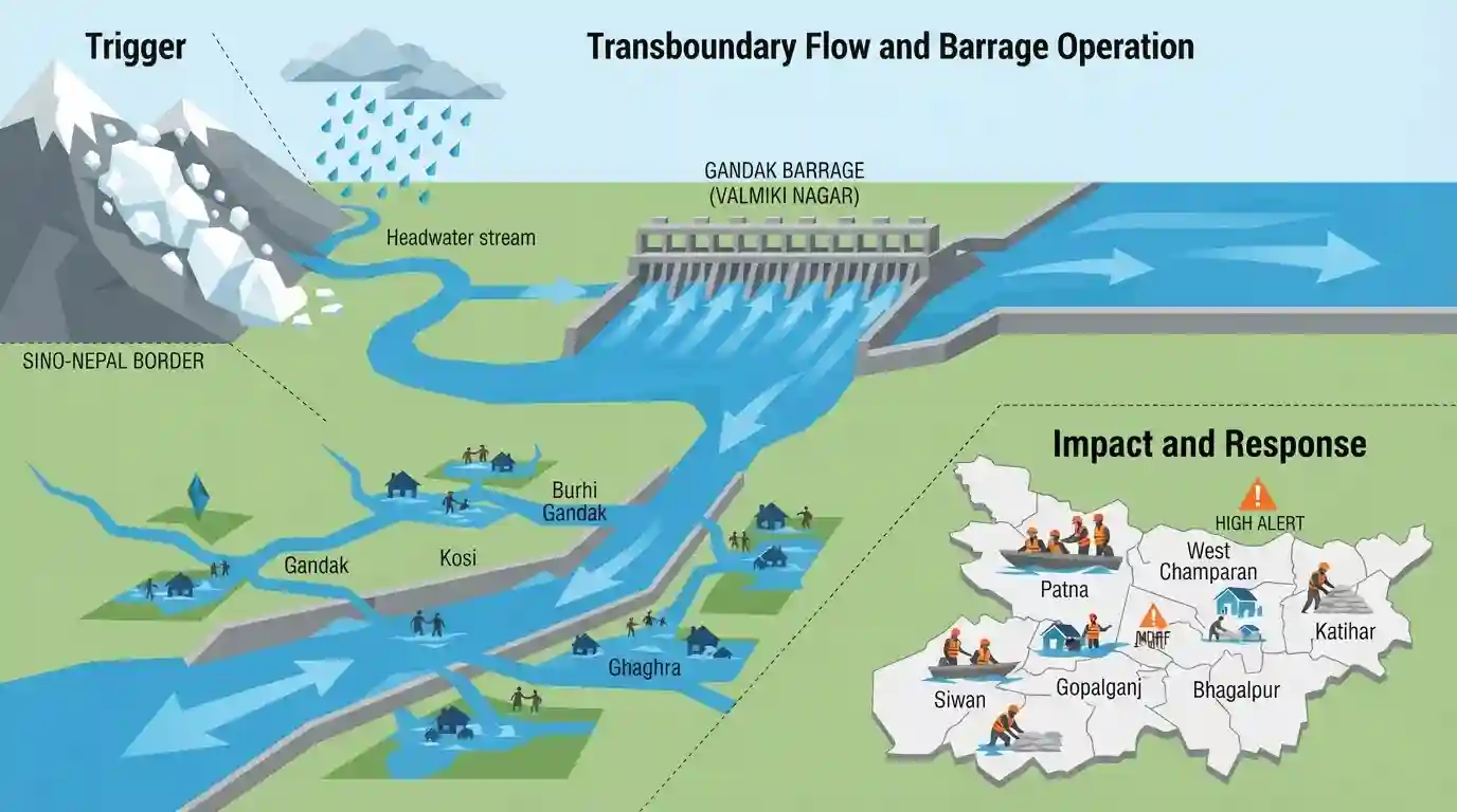
An ice-rock landslide near the Sino-Nepal border combined with heavy rainfall triggered devastating flash floods in Nepal, causing major transboundary rivers in Bihar—including the Ganga, Gandak, Kosi, Burhi Gandak, and Ghaghra—to swell to dangerous levels. In response, Bihar authorities opened all 36 gates of the Gandak Barrage at Valmiki Nagar, releasing over 1 lakh cusecs of water. Local administrations, along with the NDRF and SDRF, are on high alert, evacuating low-lying areas and monitoring vulnerable river embankments across affected districts including Patna, West Champaran, Gopalganj, Bhagalpur, Katihar, and Siwan.
Key Points
- Bihar has been placed on high alert as multiple major rivers, including the Ganga, Gandak, Kosi, Burhi Gandak, and Ghaghra, are flowing above or near their danger levels.
- The sudden rise in water levels was triggered by continuous heavy rainfall in the catchment areas of Nepal and a massive flash flood caused by an ice-rock landslide blocking a river near the Nepal-China border.
- All 36 gates of the Gandak Barrage in Valmiki Nagar (West Champaran) were opened to release 1.02 lakh cusecs of water downstream, leading to the Gandak breaching the danger level in Gopalganj.
- The Kosi and Burhi Gandak rivers have touched danger marks in Khagaria, Katihar, and Kursela, while the Ganga is flowing above the danger mark at Digha, Hathidah, Gandhighat (Patna), and Kahlgaon (Bhagalpur).
- The Ghaghra river is flowing above the danger mark at Darauli in Siwan district.
- Disaster response forces (NDRF and SDRF) have been deployed, and District DMs have been directed to personally monitor the situation and evacuate low-lying areas.
Important Terms
Water Resources Department of Bihar

A department of the Government of Bihar responsible for flood management, irrigation creation, drainage, and safeguarding state water rights in transboundary river basins.
UPSC context
GS Paper II (Bihar Administration) & GS III (Geography). Tests flood mitigation strategies and river infrastructure.
National Disaster Response Force (NDRF)
A specialized federal force established under India's Disaster Management Act, 2005, trained for swift, expert response during natural and man-made disasters.
UPSC context
GS Paper III (Disaster Management). Tests institutional frameworks for tackling regional crises like North Bihar floods.
State Disaster Response Force (SDRF)
A state-level specialized disaster response agency in Bihar, headquartered in Bihta, dedicated to local search, rescue, evacuation, and flood relief operations.
UPSC context
GS Paper II (State Administration) & GS III (Disaster Management). Tests localized disaster relief and preparedness.
Gandak Barrage
A joint Indo-Nepal barrage constructed in 1968-69 at Valmiki Nagar on the Gandak River to manage transboundary water, supply irrigation, and control floods.
UPSC context
GS Paper II (Bihar Geography/Economy). Tests river systems, canal networks, and bilateral transboundary water sharing.
Disaster Management Act, 2005
A landmark national act that established India's multi-tiered institutional disaster management architecture, including the NDMA, SDMAs, and dedicated disaster response funds.
UPSC context
GS Paper II (Polity/Legislation) & GS III (Disaster Management). Tests regulatory frameworks governing national disaster response.
Prelims Trap
The Burhi Gandak river, like the Gandak, is a transboundary glacier-fed river that originates in the high Himalayas of Nepal.
The Burhi Gandak originates locally within Bihar from Chautarwa Chaur in the Someshwar Hills of West Champaran, not the high Himalayas of Nepal.
Static Concepts Connected
What are the entry points, origins, and confluences of North Bihar's key rivers?
- Gandak River: Enters Bihar at Valmiki Nagar (West Champaran) and joins the Ganga River near Sonepur.
- Kosi River: Enters near Hanuman Nagar (Nepal) and merges with the Ganga River at Kursela in Katihar district.
- Burhi Gandak: Originates locally from Chautarwa Chaur in Someshwar Hills (West Champaran) and joins Ganga near Khagaria.
What are the historical and irrigation aspects of the Gandak river system?
- Triveni Canal: A major historical irrigation canal system constructed across the Gandak River at Valmiki Nagar.
- Sadanira River: The ancient Rigvedic name for the Gandak River, historically marking the boundary between Kosala and Videha.
Cross-Topic Patterns
Transboundary diplomacy and Bihar floods
Flood mitigation in North Bihar is heavily dependent on bilateral water management treaties and hydrological cooperation agreements, such as the Gandak and Kosi agreements with Nepal.
Disaster economics and state budget
Annual flood disasters drain Bihar's capital expenditure, routinely diverting state development budgets toward emergency reconstruction, relief operations, and embankment maintenance.

BPSC is highly likely to test the distinct local origin of Burhi Gandak versus the transboundary Himalayan origins of Gandak or Ghaghra.
Linked PYQs · 4
Linked PYQs · 4
- 2024-IBPSC_PRELIMSGS1
Which river is known as the ‘Sorrow of Bihar’?
- 2020BPSC_PRELIMSGS1
Which of the following rivers flowing in Bihar is a north flowing river?
- 2023BPSC_PRELIMSGS1
The other name of river Gandak is
- 2024-EBPSC_PRELIMSGS1
Which of the following drainage systems drains the lands of Bihar?
