Nepal Floods Impact on Uttar Pradesh Transboundary Rivers
Source:wion ↗
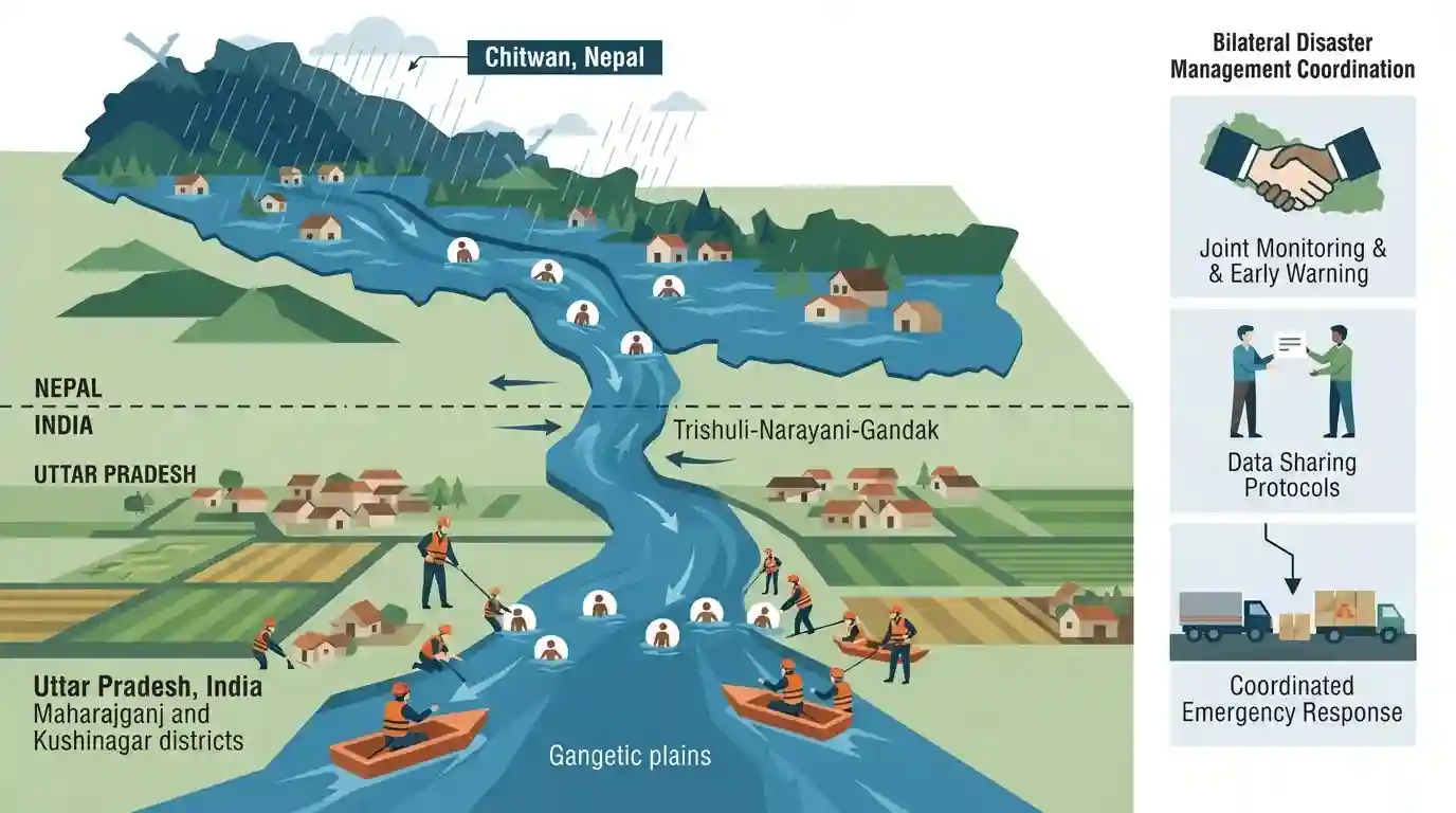
Why It Matters
This event highlights the direct physical geography connections between southern Nepal and northern/eastern Uttar Pradesh. Transboundary river systems, flood management, and the specific UP districts bordering Nepal (such as Maharajganj) are highly significant topics for UPPSC GS Paper 1 geography and state-specific questions.
Summary
Seven bodies of flood victims from Nepal's southern Chitwan region washed downstream into the transboundary rivers of Maharajganj and Kushinagar districts in Uttar Pradesh, India. This tragic event highlights the close geographic and hydrological linkages (specifically the Trishuli-Narayani-Gandak river system) between southern Nepal and northeastern Uttar Pradesh, accentuating the critical need for bilateral transboundary disaster management.
Key Points
- Seven bodies, believed to be victims of devastating flash floods in Nepal, washed downstream and were recovered in Maharajganj and Kushinagar districts of Uttar Pradesh, India.
- Four bodies were retrieved in Maharajganj district (which borders Nepal), and three were found 70 kilometers downstream in Kushinagar district.
- The victims were swept away from Nepal's southern Chitwan region due to severe flash floods and landslides, which had a reported death toll of 472 (469 in Nepal, 3 in China) with 1,400 people missing.
- The Trishuli River is a major tributary of the Narayani River (known as the Gandak River in India). It drains the Chitwan region of Nepal and flows directly into Uttar Pradesh's northeastern districts.
- The geographic location of Maharajganj as one of the seven Uttar Pradesh districts sharing a border with Nepal (alongside Pilibhit, Lakhimpur Kheri, Bahraich, Shravasti, Balrampur, and Siddharthnagar) is a critical factor in transboundary river-flow and disaster impacts.
Important Terms
Indo-Nepal Joint Committee on Inundation and Flood Management (JCIFM)

An operational joint-secretary-level bilateral body co-chaired by India and Nepal, tasked with executing flood-control works, managing inundation issues, and conducting field inspections along common transboundary rivers.
UPSC context
Relevant for UPPSC GS Paper II (Bilateral Relations) and GS Paper III (Disaster Management, transboundary river cooperation).
Gandak River
A major transboundary left-bank tributary of the Ganges. Originating in Tibet/Nepal as the Narayani, it flows through southern Nepal and enters India, traversing Bihar and Uttar Pradesh before joining the Ganges near Patna.
UPSC context
Crucial for UPPSC GS Paper I (Indian Physical Geography) and Paper V/VI (Uttar Pradesh drainage system and resources).
District Administration of Maharajganj
The administrative and executive authority in Maharajganj district, UP, responsible for district-level governance, cross-border coordination with Nepal, and managing emergency responses such as flood rescue and rehabilitation.
UPSC context
Tested under UPPSC GS Paper II (Local Administration/Governance) and Paper V/VI (Disaster Management in UP border areas).
Kushinagar District
An eastern border district of Uttar Pradesh. It is historically famous as Gautama Buddha's site of Mahaparinirvana and geographically vulnerable to transboundary downstream flood surges from Nepal's Gandak river.
UPSC context
Relevant for UPPSC GS Paper I (Ancient Indian History/Buddhism) and GS Paper V/VI (UP Geography and local administration).
Prelims Trap
Kushinagar is one of the seven physical border districts of Uttar Pradesh sharing a boundary with Nepal.
Only seven UP districts border Nepal (Pilibhit, Lakhimpur Kheri, Bahraich, Shravasti, Balrampur, Siddharthnagar, Maharajganj). Kushinagar, though heavily impacted by transboundary floods, shares no physical land border.
Static Concepts Connected
Which UP districts border Nepal and what is the Vedic significance of the Gandak River?
- Border Districts: Exactly seven UP districts share a border with Nepal: Pilibhit, Lakhimpur Kheri, Bahraich, Shravasti, Balrampur, Siddharthnagar, and Maharajganj. Kushinagar does not share a land border.
- Vedic Identity: The Gandak River is identified as the 'Sadanira' (always filled with water) in ancient Vedic literature, specifically the Shatapatha Brahmana.
- River Course: Formed by the confluence of Kali Gandaki and Trishuli rivers at Devghat (Nepal), it enters India at Triveni, passing through Maharajganj and Kushinagar in UP.
What are the characteristics of 'Bhat Alluvium' and the Gandak Megafan in UP?
- Bhat Alluvium: A highly fertile, calcareous sandy-silty newer alluvial soil unique to the Gandak plains of eastern UP (primarily Maharajganj, Kushinagar, and Deoria).
- Sugarcane Belt: The high lime (calcium) and moisture retention capacity of Bhat soil makes it exceptionally suitable for intensive sugarcane cultivation.
- Terai Ecosystem: Lies south of the Bhabhar tract, characterized by a low-lying, marshy plain prone to frequent transboundary waterlogging and flooding from Nepal's rivers.
Cross-Topic Patterns
Indo-Nepal Hydropolitics + UP Agriculture
Upstream Himalayan disasters directly impact the calcareous 'Bhat' soils of eastern UP, turning vital sugarcane-producing belts into seasonal disaster zones, requiring transboundary coordination like the JCIFM.
Ancient Geography + Modern State Borders
The 'Sadanira' (Gandak) of the Shatapatha Brahmana served as the ancient boundary of Aryan expansion, mirroring today’s complex ecological and political UP-Nepal border dynamics.

Expect questions linking UP's Nepal-bordering districts with the Vedic identity (Sadanira) and unique 'Bhat' soil profile of River Gandak.
Linked PYQs · 2
Linked PYQs · 2
- 2025UPPSC_PRELIMSGS1
With reference to hydroelectricity in North India, which of the following statements is/are correct ? 1. There are huge possibilities of hydroelectricity in the Himalayan region. 2. Eastern Uttar Pradesh and Bihar cannot utilise this potential because the Himalayas situated to their North lies in boundary of Nepal. Select the correct answer from the code given below :
- 2023UPPSC_PRELIMSGS1
Which of the following statement is correct? (1) Ram Ganga river joins the Ganga at Kannauj. (2) River Betwa joins the Yamuna near Prayagraj. Select the correct answer using the code given below –
