Delayed Southwest Monsoon Widens Rainfall Deficit in Uttarakhand
Source:timesofindia ↗
Why It Matters
Understanding the seasonal behavior of the Southwest Monsoon and localized precipitation dynamics in Uttarakhand is critical for agricultural planning, water resource management, and assessing climate change vulnerability in the Himalayan ecosystem.
Summary
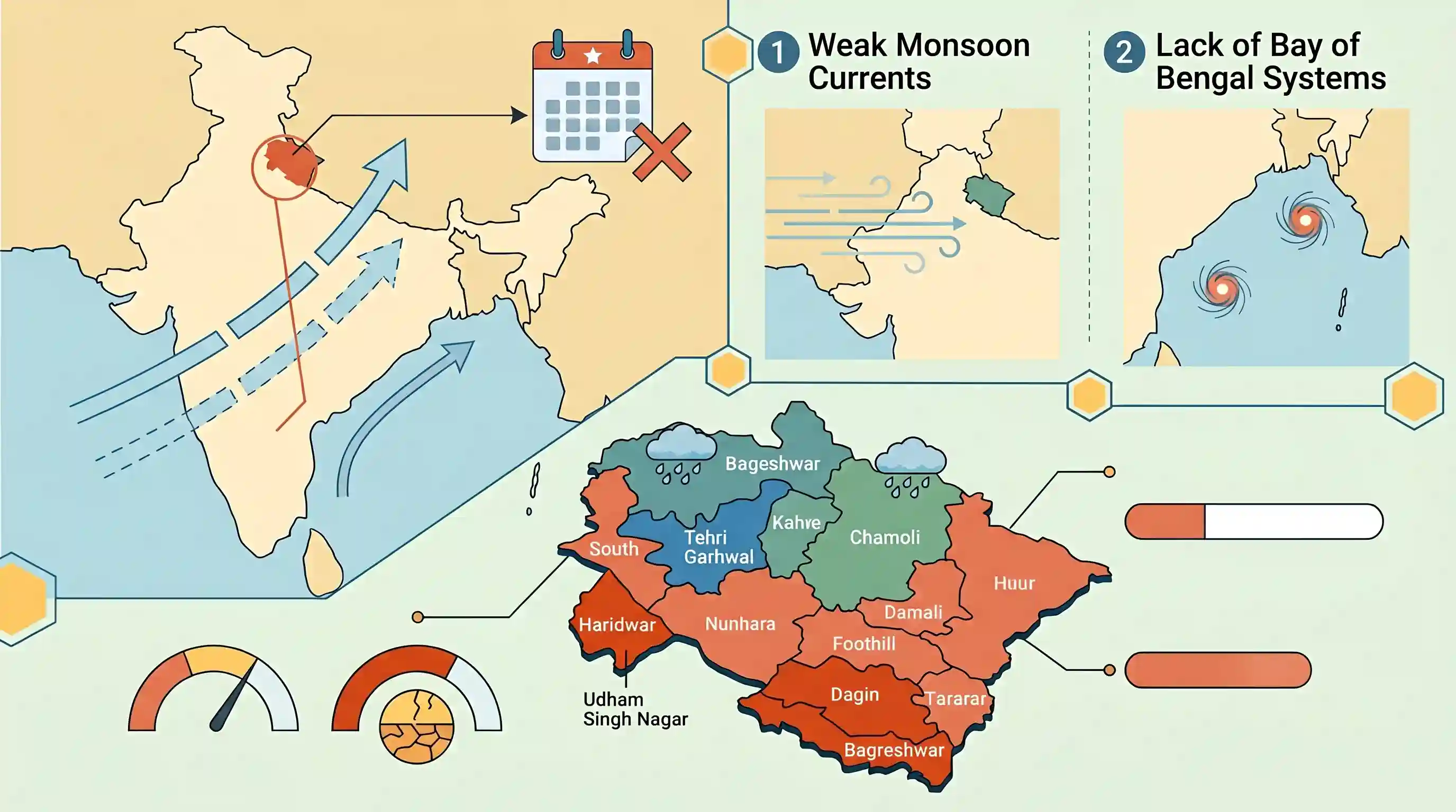
Uttarakhand faced a widening rainfall deficit of 32% during the first three weeks of June 2026 due to the delayed onset and progression of the Southwest Monsoon. The plains and foothill areas, specifically Haridwar and Udham Singh Nagar, registered the steepest shortfalls of 71% and 70% respectively, whereas only three hilly districts (Tehri Garhwal, Chamoli, and Bageshwar) saw normal to surplus precipitation. The meteorological delay is linked to weak monsoon currents over northwest India and a lack of active low-pressure systems in the Bay of Bengal.
Key Points
- Uttarakhand recorded a 32% rainfall deficit between June 1 and June 21, 2026, receiving only 70.1 mm of rainfall against the normal 103.2 mm.
- Only three of the state's 13 districts experienced normal or surplus rainfall: Tehri Garhwal (+24%), Chamoli (+1%), and Bageshwar (normal).
- The plains and foothills faced severe rain deficits, with Haridwar suffering the highest deficit in the state at 71% (23.6 mm vs. 82.4 mm normal), followed closely by Udham Singh Nagar at 70%.
- Meteorologists attributed the deficit to a delayed Southwest Monsoon, which usually arrives in Uttarakhand in the third week of June but was slowed down after a timely onset in Kerala.
- Other factors causing the dry spell include the weakening of monsoon currents over northwest India and the absence of robust low-pressure systems over the Bay of Bengal, which typically transport moisture to the Himalayan region.
Important Terms
India Meteorological Department (IMD)

India's principal government agency under the Ministry of Earth Sciences, established in 1875, responsible for meteorological observations, weather forecasting, and disaster warnings.
UPSC context
GS Paper I (Geography) and GS Paper III (Disaster Management); tests key institutional roles in climate monitoring.
Southwest Monsoon
The seasonal wind reversal occurring from June to September, bringing moisture-laden winds from the Indian Ocean to the subcontinent, contributing to over 70% of annual rainfall.
UPSC context
GS Paper I (Indian Geography - Climate); essential for understanding monsoon mechanisms, agriculture, and regional precipitation variations.
Rainfall Deficit
A meteorological condition where actual precipitation falls below the long-period average, classified by the IMD as "deficient" when the deviation is between -19% and -59%.
UPSC context
GS Paper III (Agriculture and Disaster Management); tests understanding of drought risks, crop vulnerability, and monsoon dependency.
Bay of Bengal Branch
The eastern stream of the Southwest Monsoon that carries moisture across the Bay of Bengal, turning westward along the Himalayan foothills to bring rain to Northern India.
UPSC context
GS Paper I (Climatology & Indian Geography); tests knowledge of physical monsoon branches, rainfall distribution, and regional topography.
Orographic Rainfall
Precipitation caused when moisture-laden winds are forced to rise over geographical barriers like mountains, cooling down and condensing, leading to heavy rain on windward slopes.
UPSC context
GS Paper I (Physical Geography); critical for understanding regional rainfall disparities, cloud formation, and rain-shadow zones.
Prelims Trap
The Uttarakhand Action Plan on Climate Change was drafted by the State Revenue Department under the chairmanship of the Chief Minister.
The State Council for Climate Change is headed by the Chief Secretary (not Chief Minister), and the UAPCC was prepared by the Forest/Planning departments, not the Revenue Department.
Static Concepts Connected
What drives Southwest Monsoon moisture transport to the Himalayan region?
- Monsoon Trough: Guides low-pressure depressions from the Bay of Bengal northwestward towards the Himalayan foothills.
- Tibetan Heating: Intense heating of the Tibetan Plateau strengthens the tropical easterly jet, reinforcing the monsoon current.
- Orographic Uplift: The steep Himalayan topography forces incoming moist air masses to rise, causing heavy precipitation.
What characterizes the altitudinal forest zones of Uttarakhand?
- Sub-tropical Pine: Dominated by Chir Pine up to 1500m, highly vulnerable to seasonal forest fires.
- Temperate Moist: Characterized by Oak and Rhododendron between 1500-3000m, indicating high humidity.
- Alpine Meadows: Locally known as Bugyals, found above the tree line (3000m+), supporting pastoralism.
Cross-Topic Patterns
Rainfall deficit + Hill irrigation disparity
Severe rain deficits disproportionately impact hilly districts because they lack the robust 85-90% tubewell irrigation coverage enjoyed by the plain districts.
Monsoon delay + Chir Pine fires
Delays in June monsoon onset prolong the dry pre-monsoon heat wave, desiccating pine needle litter and triggering widespread Himalayan forest fires.

UPSC may link Southwest Monsoon delay mechanisms to Himalayan altitudinal vegetation zones and local climate action plan frameworks in 2026.
Linked PYQs · 3
Linked PYQs · 3
- 2025UKPSC_PRELIMSGS1
Which of the following local winds affects some parts of Kerala and Tamil Nadu during Premonsoon season ?
- 2025UKPSC_PRELIMSGS1
Consider the following statements and select the correct answer from the options given below : Statement 1 : Uttarakhand is highly vulnerable to climate change. Statement 2 : Climate change is causing water stress and depleting biodiversity in Uttarakhand.
- 2025UKPSC_PRELIMSGS1
Which of the following districts of Uttarakhand has the highest agricultural land ?
