Uttarakhand monsoon delay and district rainfall deficits
Source:timesofindia ↗
Why It Matters
Uttarakhand-specific physical geography, district-level climate variations, and monsoon timelines are core topics frequently tested in the UKPSC PCS Prelims. Knowing which districts are mountainous (surplus/normal rain) versus plains (high deficit, which comprise ~14% of the state's area) connects directly to previous exam trends.
Summary
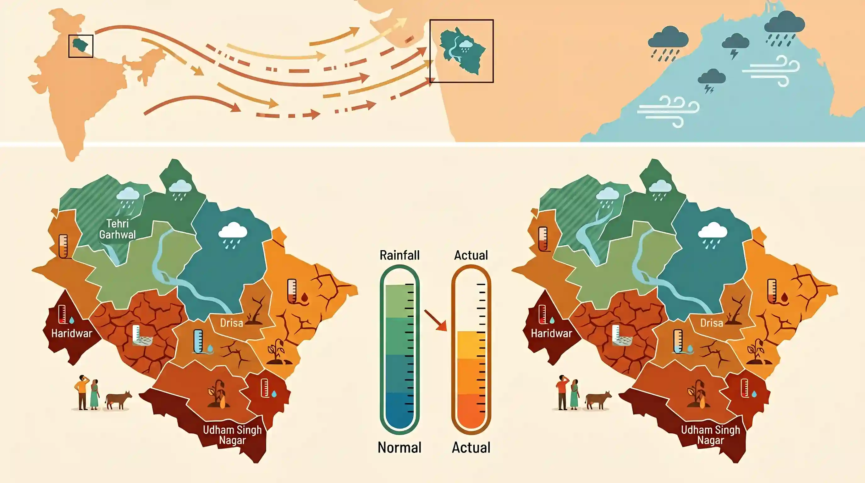
The southwest monsoon's delayed progress led to a 32% rainfall deficit in Uttarakhand during the first three weeks of June. Between June 1 and June 21, the state recorded just 70.1 mm of rainfall against a normal of 103.2 mm. Out of 13 districts, only Tehri Garhwal, Chamoli, and Bageshwar received normal/surplus rain. Plain districts like Haridwar and Udham Singh Nagar faced the highest deficits (exceeding 70%). The deficit is attributed to weak monsoon currents over northwest India and a lack of strong low-pressure systems in the Bay of Bengal.
Key Points
- Uttarakhand's rainfall deficit widened to 32% during the first three weeks of June (June 1 to June 21) due to a delay in the arrival of the southwest monsoon.
- The state received 70.1 mm of rainfall against the historical normal of 103.2 mm for this period.
- Of the 13 districts in Uttarakhand, only three recorded normal or surplus rainfall: Tehri Garhwal (+24%), Chamoli (+1%), and Bageshwar (normal).
- The plains and foothills suffered the most severe rainfall shortfalls, with Haridwar recording the highest deficit at 71% (23.6 mm received vs. 82.4 mm normal), followed by Udham Singh Nagar at -70%.
- Deficits in other districts included Pithoragarh (-50%), Pauri Garhwal (-44%), Champawat (-41%), Nainital (-37%), Dehradun (-36%), Uttarkashi (-31%), and Rudraprayag (-16%).
- Meteorologists attributed the delayed monsoon advance to the weakening of favorable monsoon currents over northwest India and the absence of strong low-pressure systems over the Bay of Bengal, which restricted moisture flow into the Himalayan region.
- Although western disturbances and localized convective thunderstorms brought some scattered showers, they were insufficient to offset the overarching deficit.
Important Terms
India Meteorological Department (IMD)

The principal government agency under India’s Ministry of Earth Sciences responsible for meteorological observations, weather forecasting, seismology, and issuing early warnings.
UPSC context
GS Paper I (Geography) and Paper III (Disaster Management). Tests institutional frameworks for weather monitoring and disaster warning.
Southwest Monsoon
The seasonal wind system bringing moisture-laden air from the Indian Ocean to India from June to September, supplying 70-75% of annual rainfall.
UPSC context
GS Paper I (Indian Geography - Climatology). Tests mechanics of monsoon systems, spatial-temporal variations, and impact on agriculture.
Meteorological Drought
A situation characterized by a prolonged period of inadequate precipitation, typically defined by the IMD as a deficiency of 25% or more below normal.
UPSC context
GS Paper I (Physical Geography) and Paper III (Disaster Management). Tests rainfall deficit classification and climate-resilient water-management strategies.
Regional Meteorological Centre, Dehradun
The state-level unit of the IMD (locally called Meteorological Centre Dehradun), operating under RMC New Delhi, that monitors weather and issues regional alerts.
UPSC context
GS Paper III (Disaster Management). Tests local weather forecasting, mountain meteorology, and hazard mitigation in ecologically fragile Himalayan terrains.
Prelims Trap
The Arabian Sea branch of the Southwest Monsoon serves as the primary driver of monsoon precipitation in Uttarakhand.
While geographically western, Uttarakhand's monsoon is primarily driven by the Bay of Bengal branch, which deflects westward along the Himalayas, causing heavy mountain rainfall.
Static Concepts Connected
How do the Southwest Monsoon branches interact with India's mountain systems?
- Bay of Bengal: Deflects westward along the Himalayas, acting as the primary rainfall source for most of Northern and North-Western India, including Uttarakhand.
- Arabian Sea: Strikes the Western Ghats and moves parallel to the Aravallis, offering lesser penetration to the Himalayan foothills compared to the eastern branch.
- Orographic barrier: The Himalayas block northward migration of moisture, forcing it to precipitate along the foothills and southern slopes.
What is the structural framework of State Action Plans on Climate Change?
- National alignment: Formulated by states to operationalize the National Action Plan on Climate Change (NAPCC) objectives at the sub-national level.
- Nodal implementation: Led by State Climate Change Cells/Councils (often under Environment Departments) rather than disaster management or revenue authorities.
Cross-Topic Patterns
Monsoon dynamics & Himalayan border security
Climate-induced rainfall deficits in strategic border districts like Pithoragarh and Chamoli threaten local water security, impacting border area development and military logistics.
Forest buffers vs macro-climate drivers
Even high forest-cover zones (like Nainital at ~71.6%) experience severe drought-like deficits when global or regional synoptic systems (Bay of Bengal low pressures) weaken.

Topographic control of monsoon branches and sub-national climate action plans (SAPCC) likely to feature as a multi-statement GS-I question.
Linked PYQs · 2
Linked PYQs · 2
- 2025UKPSC_PRELIMSGS1
Consider the following statements and select the correct answer from the options given below : Statement 1 : Uttarakhand is highly vulnerable to climate change. Statement 2 : Climate change is causing water stress and depleting biodiversity in Uttarakhand.
- 2024UKPSC_PRELIMSGS1
What percentage (approximately) of Uttarakhand is plain area ?
