Gujarat districts face heavy monsoon rains and high dam water levels
Source:newsonair ↗
Why It Matters
Understanding rainfall patterns, river systems, and major dams (like Sardar Sarovar) in Gujarat is directly relevant to the Geography syllabus of GPSC Class 1-2 Prelims. The involvement of the NDRF and SDRF highlights the practical aspects of disaster management and state administration during natural calamities.
Summary
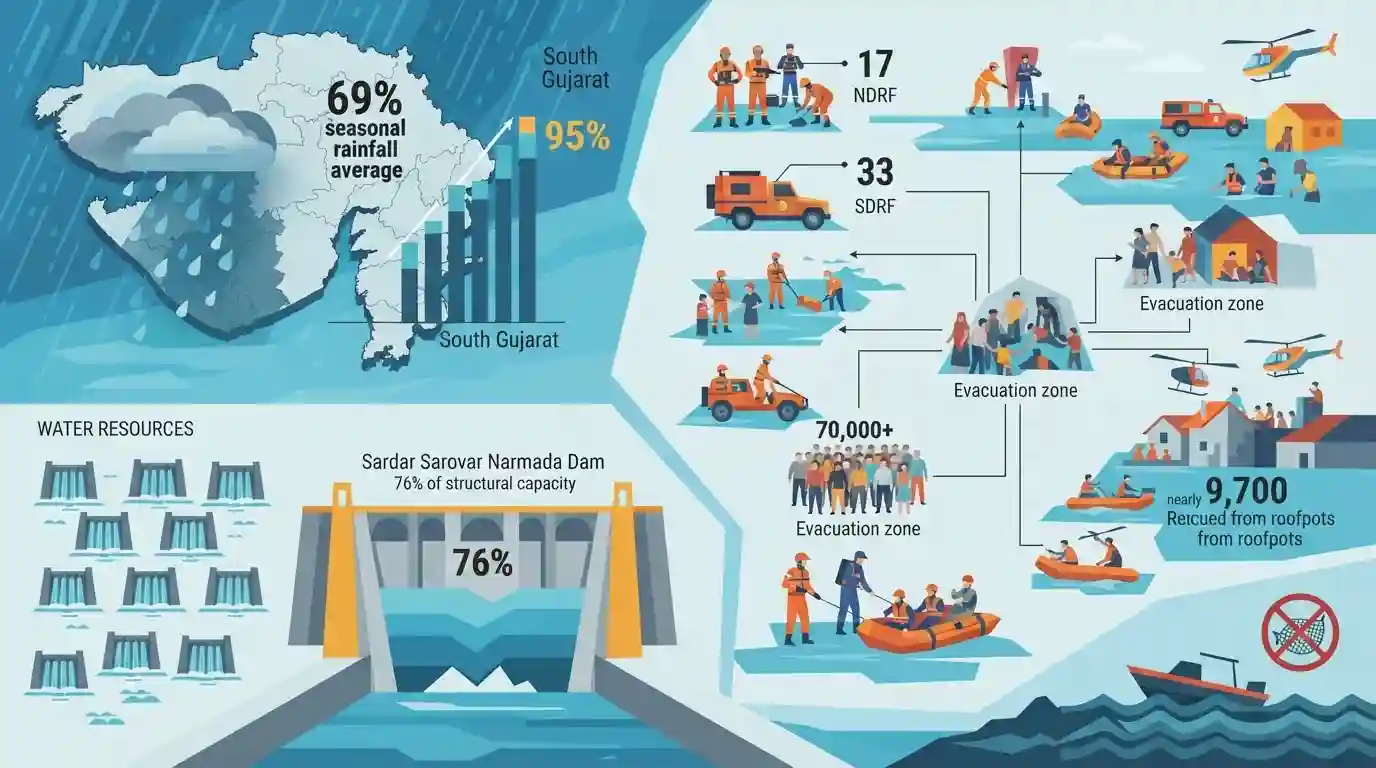
The India Meteorological Department (IMD) has forecast heavy to very heavy rainfall in several districts of Gujarat, prompting extensive disaster management responses. The state has already received 69% of its seasonal average rainfall, with South Gujarat recording over 95%. Consequently, 33 dams are on high alert, and the critical Sardar Sarovar Narmada Dam has reached 76% capacity. To manage the flood-like situation, 17 National Disaster Response Force (NDRF) and 33 State Disaster Response Force (SDRF) teams have been deployed, resulting in the evacuation of over 70,000 individuals and the rescue of nearly 9,700 people. Fishermen have been advised against venturing into the sea due to severe weather conditions.
Key Points
- The IMD has predicted heavy to very heavy rainfall across various districts of Gujarat, including Kutch, Banaskantha, Patan, and Morbi.
- Gujarat has received 69% of its average seasonal rainfall so far, with South Gujarat receiving the highest at 95.03%.
- 33 dams in the state have been put on high alert due to rising water levels.
- The Sardar Sarovar Dam on the Narmada River currently holds 76% of its water storage capacity.
- Significant rescue and relief operations are underway with the deployment of 17 NDRF and 33 SDRF teams across the state.
- Over 70,000 people have been evacuated to safer locations, and 9,680 people have been rescued, including notable operations in Morbi district.
Important Terms
India Meteorological Department (IMD)

The principal Indian government agency under the Ministry of Earth Sciences responsible for meteorological observations, weather forecasting, and seismology, including predicting monsoons and severe weather events.
UPSC context
Tests knowledge in GS Paper 1 (Geography) and GS Paper 3 (Disaster Management) concerning early warning systems and climate forecasting.
National Disaster Response Force (NDRF)
A specialized multi-disciplinary paramilitary force established under the Disaster Management Act, 2005. It operates under the Ministry of Home Affairs to provide immediate response during disasters.
UPSC context
Key to GS Paper 3 (Disaster Management). Tests understanding of India's statutory institutional framework and central capacity for emergency response.
State Disaster Response Force (SDRF)
A state-level specialized force mandated by the Disaster Management Act, 2005. It acts as the first line of organized defense for search, rescue, and relief operations during local calamities.
UPSC context
Relevant for GS Paper 3 (Disaster Management) to evaluate knowledge of decentralized emergency response and state-level capacity building.
Sardar Sarovar Dam
A massive concrete gravity dam on the Narmada River in Gujarat. It is a multipurpose project providing irrigation, drinking water, and hydroelectricity to Gujarat, Madhya Pradesh, Maharashtra, and Rajasthan.
UPSC context
Important for GS Paper 1 (Geography) and GS 3 (Infrastructure). Highlights water resource management, interstate river projects, and environmental debates.
Prelims Trap
"The State Disaster Response Fund (SDRF) is fully funded by the respective state governments."
The Centre contributes 75% of the SDRF allocation for general category states and 90% for special category states. It is not fully state-funded.
Static Concepts Connected
What do the IMD's four colour-coded weather warnings signify?
- Green (Normal): No severe weather expected. No advisory is issued.
- Yellow (Watch): Be updated. Indicates severely bad weather spanning across several days. Localized disruptions are possible.
- Orange (Alert): Be prepared. Significant weather phenomenon expected with potential for power outages, communication disruptions, and transport delays.
- Red (Warning): Take action. Extremely bad weather expected to cause widespread disruption to transport, power, and risk to life.
What are the key geographical features of the Narmada River basin?
- Origin: Rises from the Amarkantak Plateau in Madhya Pradesh.
- Rift Valley Flow: It is the largest west-flowing river in India, flowing through a rift valley between the Vindhya and Satpura ranges.
- Sardar Sarovar Dam: A terminal dam on the Narmada in Gujarat; it is a multi-state project benefiting Gujarat, Madhya Pradesh, Maharashtra, and Rajasthan.
Cross-Topic Patterns
Changing monsoon patterns in arid zones
Heavy rainfall in traditionally arid regions like Kutch indicates shifting monsoon troughs and climate change-induced extreme weather, a frequent theme mapping GS1 geography to GS3 environment.
Narmada Dam and Inter-state Hydro-politics
The Sardar Sarovar Dam connects GS2 (inter-state water disputes) and GS3 (disaster management), as upstream water release from Madhya Pradesh frequently impacts flood management in Gujarat.

Expect a Prelims statement linking shifting monsoon troughs causing floods in arid zones (Kutch) with SDRF center-state funding ratios.
Linked PYQs · 3
Linked PYQs · 3
- 2026GPSC_PRELIMSGS1
Consider the following statements regarding the drainage system of Kutch: 1. Most rivers in the Kutch region are ephemeral and non-perennial, carrying water only during the brief monsoon season. 2. The rivers originating from the central hilly tracts of Kutch invariably drain into the Arabian Sea directly. 3. The Luni River, after traversing through Rajasthan, dissipates into the marshy lands of the Rann of Kutch. Which of the above statements are correct?
- 2021GPSC_PRELIMSGS1
Match the column: | Waterfall | District | |---|---| | 1. Zanzhari Waterfall | a. Narmada | | 2. Zharwani Waterfall | b. Aravalli | | 3. Girmall Waterfall | c. Tapi | | 4. Chimer Waterfall | d. Dangs | Code:
- 2019GPSC_PRELIMSGS1
Which of the following statements are correct regarding excavated sites in Gujarat? Site On the River/Or Esle 1. Lothal Saraswati 2. Rojadi Bhadar 3. Dholavira In the Desert of Kutch 4. Malvan Tapi
