Sutlej basin glacial retreat threatens Himachal hydropower generation
Source:newsarenaindia ↗
Why It Matters
Himachal Pradesh\'s economy and energy output heavily depend on glacier-fed rivers. Understanding the intersection of geography, climate change, and infrastructure vulnerabilities is vital for disaster management and formulating effective adaptation strategies in the Himalayan region.
Summary
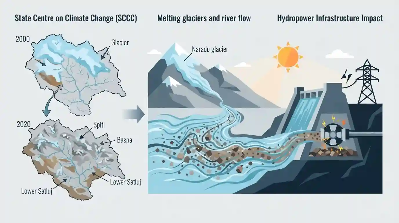
A detailed climate study conducted by the State Centre on Climate Change (SCCC) for Satluj Jal Vidyut Nigam Limited (SJVNL) indicates that rapid glacier retreat in the Sutlej basin poses a severe threat to Himachal Pradesh\'s hydropower sector. The research observed a significant reduction in glacier cover across the Spiti, Baspa, Upper Satluj, and Lower Satluj sub-basins from 2000 to 2020. Melting glaciers, including the steadily thinning Naradu glacier, are expected to cause unpredictable river flows and higher sediment loads, which can damage hydropower turbines and severely impact electricity generation, a major source of revenue for the state.
Key Points
- A comprehensive study by HIMCOSTE\'s State Centre on Climate Change (SCCC) warns of shrinking ice cover in the Sutlej basin, affecting the Spiti, Baspa, Upper Satluj, and Lower Satluj sub-basins.
- Glacier cover in the Sutlej basin declined from 1,481.75 sq km in 2000 to 1,384.16 sq km in 2020, with the majority retreating by less than 10 meters annually.
- The Naradu glacier is among those showing consistent thinning despite temporary reliefs during years of heavy snowfall.
- The faster melting and retreat of glaciers, driven by rising temperatures and altered snowfall patterns, will make river flows unpredictable and increase sediment loads.
- The increased sediment and fluctuating water levels threaten to damage turbines and drastically reduce electricity generation for Himalayan hydropower projects.
Important Terms
State Centre on Climate Change (SCCC)

An institutional framework under Himachal Pradesh's environment council. It coordinates climate adaptation strategies, tracks Himalayan cryosphere patterns, and assesses state vulnerabilities to environmental changes.
UPSC context
GS-3 (Environment). Highlights state-level institutional frameworks for executing climate action and conserving Himalayan ecosystems.
Satluj Jal Vidyut Nigam Limited (SJVNL)
A Mini Ratna public sector enterprise formed as a joint venture between the Indian Government and Himachal Pradesh. It executes and maintains major hydroelectric and renewable energy projects.
UPSC context
GS-3 (Infrastructure/Energy). Relevant for India's renewable energy transition, public sector utility roles, and hydropower sector expansion.
Sutlej Basin
A major Indus tributary drainage area in the northwestern Himalayas. Heavily utilized for hydropower, it faces severe glacial retreat that threatens long-term water flow predictability and regional energy security.
UPSC context
GS-1 (Geography). Vital for map-based questions, Himalayan hydrology, and studying the localized impacts of climate change on resources.
Naradu Glacier
A steadily thinning glacier located in the Baspa sub-basin of Himachal Pradesh. Its rapid melting threatens the predictable river flows essential for powering downstream hydroelectric plants.
UPSC context
GS-1 (Geography). High potential for Prelims mapping or conceptual questions regarding climate-affected cryosphere regions in the Himalayas.
Glacial Retreat
The shrinking of glacier ice mass due to rising temperatures and changing precipitation patterns. This phenomenon reduces dry-season snow-melt runoff, increases river sedimentation, and disrupts critical hydropower infrastructure.
UPSC context
GS-1 (Geography) & GS-3 (Environment). Core concept for explaining cryosphere degradation, water security, and associated economic impacts.
Prelims Trap
The Sutlej River originates from Lake Mansarovar and is joined by the Spiti River as its major left-bank tributary.
Sutlej originates from Lake Rakshastal (not Mansarovar) and is an antecedent river. Spiti is its right-bank tributary, while Baspa is its left-bank tributary.
Static Concepts Connected
What is antecedent drainage and how does the Sutlej River demonstrate this?
- Definition: Antecedent streams existed before mountain uplift and cut deep gorges to maintain their original path as land rose.
- Sutlej Example: Sutlej cuts through the Great Himalayas via deep gorges near the Shipki La pass to enter India.
- Other Examples: The Indus, Brahmaputra, and Kosi rivers also display classic antecedent drainage patterns in the Himalayan system.
What are the major geographical features of the Sutlej river basin?
- Source and Entry: Originates from Rakas Lake (Rakshastal) in Tibet and enters India via Shipki La pass in Kinnaur, Himachal Pradesh.
- Spiti Tributary: A significant right-bank tributary that originates from the Kunzum Range and flows through the Spiti valley.
- Baspa Tributary: A major left-bank tributary originating from the Baspa hills, joining the Sutlej at Karcham.
Cross-Topic Patterns
Hydropower transition vs Climate vulnerability
Clean energy mandates (SDG 7) relying on run-of-the-river projects face operational threats from climate-induced glacier retreat, altering river siltation patterns and hydrology.
GLOF risks and disaster planning
Rapid glacial thinning forms unstable moraine-dammed lakes, shifting the disaster management paradigm under Sendai Framework from post-disaster response to proactive glacial monitoring.

Expect a 2026 Prelims question linking antecedent Himalayan rivers, right/left bank tributaries, and downstream run-of-the-river risks.
Linked PYQs · 3
Linked PYQs · 3
- 2024HPAS_PRELIMSGS1
Arrange the following climatic zones of Himachal Pradesh according to rainfall amount from lowest to highest : (1) Frigid aridic zone (2) Wet temperate zone (3) Humid sub-tropical zone (4) Sub-humid sub-tropical zone Choose the correct answer from the options given below :
- 2022HPAS_PRELIMSGS1
Milam glacier is located in :
- 2023HPAS_PRELIMSGS1
Consider the following statements : (1) The rainiest district in Himachal Pradesh is Kangra. (2) Rainfall in the Alpine region of Himachal Pradesh varies between 300-600 mm. (3) Winter season in Himachal Pradesh extends from October to March. (4) Mandi is the hottest place in Himachal Pradesh. Choose the correct answer from the options given below :
