Sir Creek Security Challenges Rise Amid Pakistani Drone Activities
Source:The Hindu ↗
Why It Matters
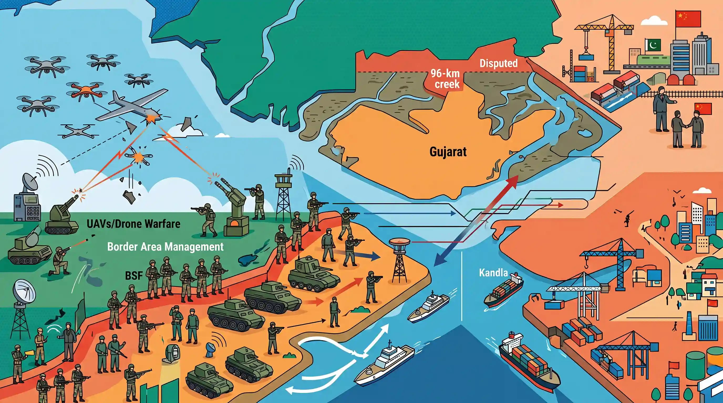
The Sir Creek dispute represents a complex intersection of territorial, economic, and security challenges for India. The increasing use of asymmetric warfare, such as drone strikes (Operation Sindoor), and the strategic encirclement via Chinese investments (CPEC-related) make this a critical case study for GS-3 Internal Security and Border Management.
Summary
The article highlights escalating security concerns in the Sir Creek region, a disputed 96-km marshland estuary between India's Gujarat and Pakistan's Sindh province. Driven by recent hostile maneuvers from Pakistan, notably the foiled drone offensive termed 'Operation Sindoor', India has aggressively fortified its layered security matrix involving the BSF, military, and Coast Guard. The dispute is complicated by the area's economic potential and its proximity to key Indian commercial ports like Kandla and Mundra. Furthermore, Chinese-backed infrastructure developments on the Pakistani side of the Rann of Kutch underscore a growing collusive threat, reinforcing the need for India to maintain stringent vigilance and robust border management in this complex terrain.
Key Points
- Sir Creek is a 96-km long disputed estuarine marshland between Gujarat (India) and Sindh (Pakistan) that remains vital due to its economic potential (fishing, oil/gas) and strategic location.
- Recent Pakistani adventurism, including Operation Sindoor (a foiled drone strike aimed at Indian military infrastructure), has prompted severe warnings from the Indian Defence Ministry.
- India maintains a comprehensive, layered security grid in the difficult terrain, utilizing the BSF, Army, Coast Guard, Navy, and IAF to monitor the coastline.
- The proximity of Sir Creek to critical Indian maritime infrastructure, such as the Kandla and Mundra ports, amplifies the region's strategic vulnerability.
- The strategic challenge is further complicated by Chinese-backed mining and power projects on the Pakistani side of the Rann of Kutch, strengthening the China-Pakistan axis near India's borders.
Important Terms
Sir Creek

A 96-km tidal estuary in the Rann of Kutch marshlands, separating Gujarat (India) and Sindh (Pakistan). It is a disputed maritime boundary due to conflicting interpretations of a 1914 colonial resolution.
UPSC context
GS-II/GS-III; tests understanding of India-Pakistan border disputes, maritime boundaries, and the UNCLOS framework.
Thalweg Principle
International legal principle stating that a boundary between two political entities separated by a waterway follows the mid-channel of the deepest navigable course. India invokes this for the Sir Creek dispute.
UPSC context
GS-II; important for international relations and legal mechanisms in resolving territorial/riparian disputes.
Operation Sindoor
A 2025 Indian tri-services military offensive involving precision drone and missile strikes against terrorist infrastructure and military assets in Pakistan, launched in response to the Pahalgam terror attack.
UPSC context
GS-III; relevant for internal security, defense doctrine, and the evolution of non-contact/drone warfare.
Border Security Force (BSF)
India's "First Line of Defence," a Central Armed Police Force (CAPF) guarding the borders with Pakistan and Bangladesh. It operates specialized "Creek Crocodile Commandos" in the marshy Rann of Kutch.
UPSC context
GS-III; core organization for border management, internal security, and coastal-marshland surveillance.
Indian Coast Guard (ICG)
A multi-mission maritime force under the Ministry of Defence responsible for maritime law enforcement, coastal security, and search and rescue operations in India's territorial waters and EEZ.
UPSC context
GS-III; essential for coastal security architecture and protecting maritime economic interests (fisheries/hydrocarbons).
Rann of Kutch
A seasonal salt marsh in Gujarat, India, divided into the Great Rann and Little Rann. It forms the geographical backdrop for the Sir Creek dispute and Harami Nala.
UPSC context
GS-I/GS-III; tests knowledge of unique Indian geography and its impact on border security challenges.
Prelims Trap
"India claims the entire Sir Creek estuary based on the 1914 Bombay Government Resolution."
India actually relies on the internationally recognized Thalweg Principle (mid-channel boundary), whereas Pakistan claims the entire creek based on the 1914 resolution.
Static Concepts Connected
What are the core legal arguments in the Sir Creek dispute?
- Thalweg Principle: An international law principle stating river boundaries are drawn down the middle of the main navigable channel. India advocates this for dividing Sir Creek.
- 1914 Bombay Resolution: A historical pact between the Government of Sindh and Rao Maharaj of Kutch. Pakistan interprets its accompanying map to claim the creek's entire eastern bank.
How is India's coastal security geographically structured?
- State Marine Police: Responsible for patrolling shallow coastal waters, typically maintaining jurisdiction up to 12 nautical miles from the coastline.
- Indian Coast Guard: Secures territorial waters and the Exclusive Economic Zone (EEZ), operating generally between 12 and 200 nautical miles.
- Indian Navy: Maintains overarching responsibility for national maritime defense, operating on the high seas beyond 200 nautical miles and coordinating the entire grid.
Cross-Topic Patterns
UAV threats & Border Management System
The shift from cross-border smuggling to direct UAV offenses (Operation Sindoor) requires integrating anti-drone technology into the Comprehensive Integrated Border Management System (CIBMS) for marshy terrains.
China's dual-use infrastructure strategy
Chinese-backed mining and power projects in Pakistan's Sindh mirror its 'Xiaokang' border-village strategy along the LAC, converting civilian infrastructure into dual-use military outposts near Indian territory.
Commercial port vulnerability to border disputes
The proximity of Mundra and Kandla (Deendayal) ports to the disputed Sir Creek marshlands tightly intertwines India's maritime trade security with its territorial border disputes.

Expect a 2026 geography mapping question linking Sir Creek, Kandla/Mundra ports, and the Thalweg Principle paired with coastal security.
Linked PYQs · 3
Linked PYQs · 3
- 2023MainsGS3
The use of unmanned aerial vehicles (UAVs) by our adversaries across the borders to ferry arms/ammunitions, drugs, etc., is a serious threat to the internal security. Comment on the measures being taken to tackle this threat.
- 2020MainsGS3
For effective border area management, discuss the steps required to be taken to deny local support to militants and also suggest ways to manage favourable perception among locals.
- 2012MainsGS2
Do you think that China's emergence as one of the largest trading partners of India has adversely affected the settlement of the outstanding border problem?
