Magnitude Six Point Nine Earthquake Strikes Central Philippines
Source:The Hindu ↗
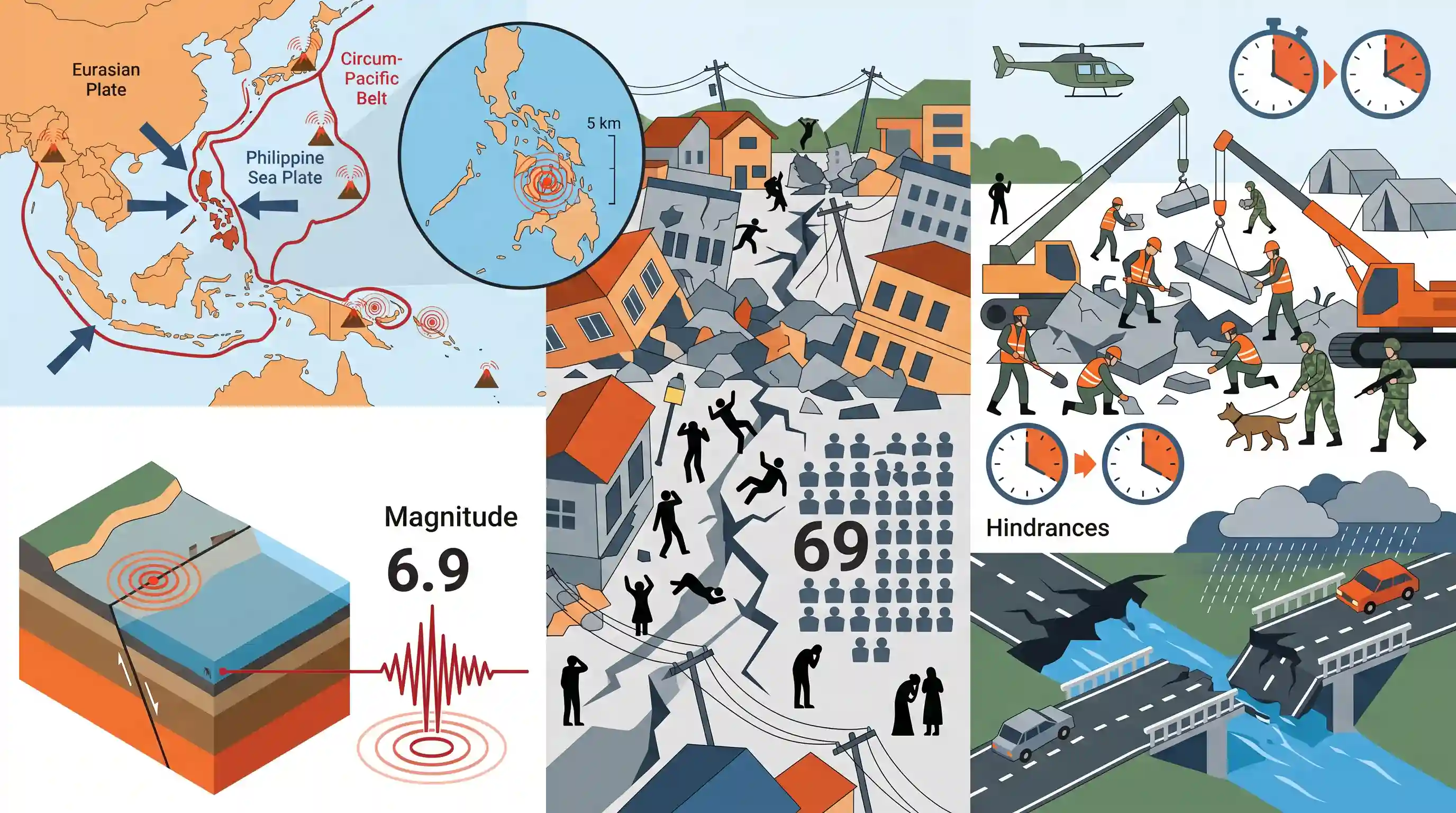
Why It Matters
The Philippines' location on the Pacific Ring of Fire makes it highly susceptible to seismic activity. Shallow earthquakes often cause more severe surface damage. This event highlights the geographical factors behind tectonic hazards (GS1) and the practical challenges of urban search-and-rescue and disaster response (GS3).
Summary
A powerful magnitude 6.9 earthquake hit the central Philippines, specifically impacting Bogo City in Cebu province, resulting in at least 69 deaths. The earthquake originated from an undersea fault line at a dangerously shallow depth of 5 km. Rescue operations by the military and civil defence are utilizing the critical "golden hour" to search for survivors amidst collapsed structures, though efforts are being hindered by damaged roads, bridges, and adverse weather.
Key Points
- A shallow, magnitude 6.9 earthquake struck the central Philippines, centered near Bogo city in Cebu province.
- The tremor was triggered by movement in an undersea fault line at a depth of just 5 kilometers, causing significant structural collapses.
- Search and rescue operations, emphasizing the critical "golden hour," are being conducted by the Office of Civil Defence alongside military and civilian volunteers.
- Rescue efforts are currently hampered by damaged infrastructure, such as bridges and roads, as well as intermittent rain.
Important Terms
Circum-Pacific Belt (Ring of Fire)

A 40,000 km horseshoe-shaped zone encircling the Pacific Ocean where 90% of the world's earthquakes and 75% of active volcanoes occur due to tectonic plate boundaries.
UPSC context
GS Paper I: Important Geophysical phenomena (Earthquakes/Volcanoes). Crucial for understanding global seismic distribution and plate tectonics.
Shallow-focus Earthquake
An earthquake with a focal depth of less than 70 km. These typically cause greater surface destruction as seismic energy has less distance to dissipate.
UPSC context
GS Paper I: Geography. Explains why moderate-magnitude quakes (like 6.9) can be catastrophic if the focus is shallow.
Golden Hour
The critical first hour (or window) following a disaster or traumatic injury when rapid medical or rescue intervention significantly increases the chances of survival.
UPSC context
GS Paper III: Disaster Management. Key concept for evaluating the efficiency of rescue operations and emergency medical response.
Epicenter
The point on the Earth's surface directly above the focus (hypocenter) of an earthquake, typically experiencing the strongest seismic intensity and maximum damage.
UPSC context
GS Paper I: Physical Geography. Basic seismological terminology required for describing disaster impacts in descriptive answers.
Disaster Management Cycle
A four-phase framework comprising Mitigation, Preparedness, Response, and Recovery used by agencies to manage and reduce the overall impact of disasters.
UPSC context
GS Paper III: Disaster Management. Fundamental model for answering questions on policy, institutional frameworks, and rescue strategies.
Office of Civil Defence (OCD)
The Philippine government agency responsible for coordinating disaster risk reduction and management (similar to India’s National Disaster Management Authority).
UPSC context
GS Paper II/III: Governance/Disaster Management. Illustrates international institutional frameworks for disaster response and inter-agency coordination.
Prelims Trap
"Deep-focus earthquakes are more destructive than shallow-focus earthquakes because they release energy from greater tectonic depths."
Shallow-focus earthquakes (like this 5km deep event) are actually more destructive. Their seismic waves travel shorter distances to the surface, causing intense shaking.
Static Concepts Connected
How do shallow and deep-focus earthquakes differ in tectonic origin and impact?
- Shallow focus: Originate at 0–70 km depth and occur at all tectonic plate boundaries (divergent, convergent, and transform).
- Deep focus: Originate at 300–700 km depth and are almost exclusively restricted to convergent boundaries (Wadati-Benioff subduction zones).
- Destruction variance: Shallow quakes are more destructive because seismic waves travel shorter distances, delivering concentrated energy to the surface.
How does the Sendai Framework address infrastructure resilience?
- Target 4 (Target D): Aims to substantially reduce disaster damage to critical infrastructure and disruption of basic services.
- Build Back Better: Focuses on incorporating disaster-resilient designs during post-disaster recovery, rehabilitation, and reconstruction phases.
- India's role: India launched the Coalition for Disaster Resilient Infrastructure (CDRI) globally to operationalize these exact Sendai mandates.
Cross-Topic Patterns
Post-Disaster Rescue + CDRI mandate
The obstruction of rescue efforts by collapsed bridges in Cebu directly underscores the rationale behind India's Coalition for Disaster Resilient Infrastructure (CDRI) and Sendai Target D.
Philippine Plate + Dual Subduction
The Philippines occupies a complex tectonic zone flanked by opposite-facing subduction zones (Philippine Sea Plate and Sunda Plate), contrasting with simpler single-fault boundaries.

Expect a multi-statement Prelims question correlating earthquake depth (shallow vs. deep focus) with specific tectonic boundary types.
Linked PYQs · 3
Linked PYQs · 3
- 2020MainsGS1
Discuss the geophysical characteristics of Circum-Pacific Zone.
- 2025MainsGS1
Discuss how the changes in shape and sizes of continents and ocean basins of the planet take place due to tectonic movements of the crustal masses.
- 2024MainsGS3
What is disaster resilience? How is it determined? Describe various elements of a resilience framework. Also mention the global targets of Sendai Framework for Disaster Risk Reduction (2015–2030).
