Bangladesh Earthquake and Bengal Basin Seismic Vulnerability
Source:The Hindu ↗
Why It Matters
This event serves as a practical case study for UPSC aspirants on the intersection of physical geography (plate tectonics, fault lines) and disaster management. It highlights the specific vulnerabilities of alluvial basins like the Bengal Basin to seismic wave amplification, stressing the critical need for robust urban planning and disaster resilience in densely populated regions.
Summary
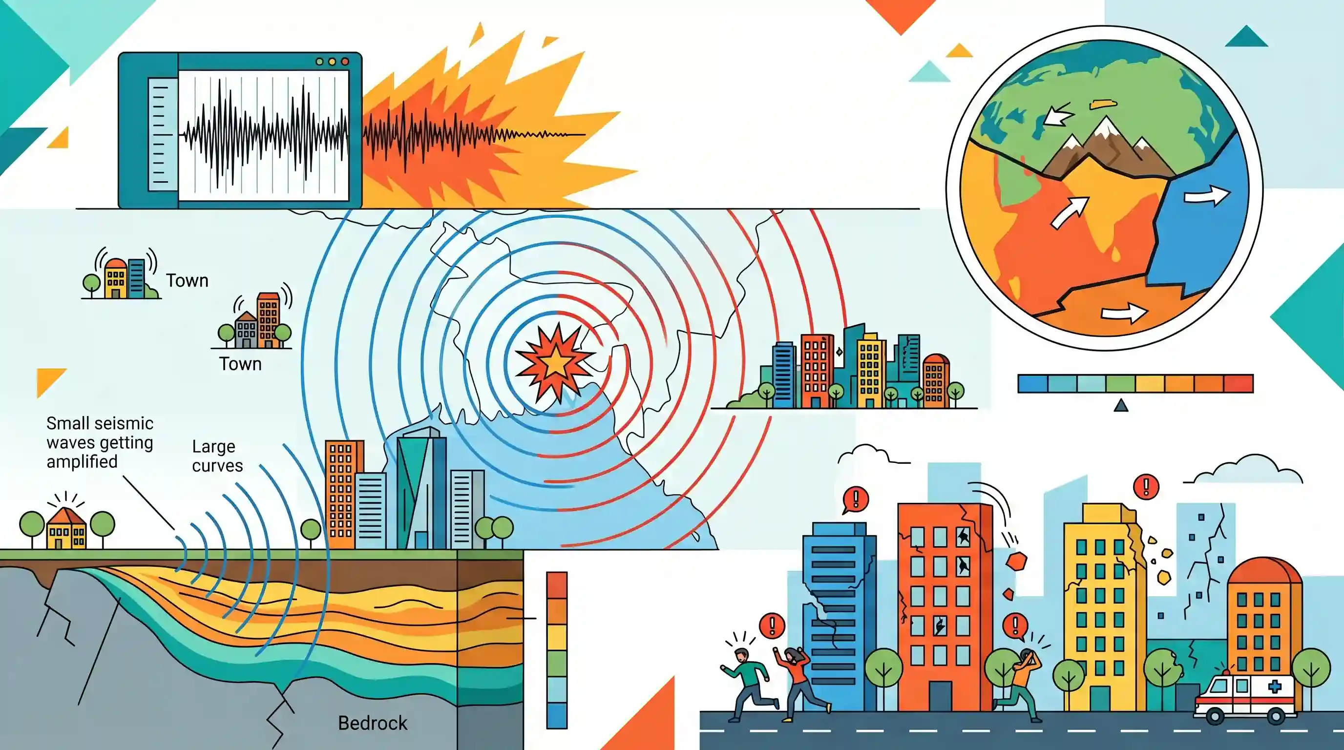
A magnitude 5.4 earthquake struck Bangladesh, sending strong tremors through Kolkata and neighboring districts in West Bengal. The seismic event caused panic and localized structural damage, particularly in border districts like North 24 Parganas. The earthquake's occurrence highlights the active tectonic dynamics of the region, which is heavily influenced by the continuous northward movement of the Indian Plate as it collides with the Eurasian Plate. Underlying geological features, such as the Sylhet Fault and the Calcutta-Mymensingh Hinge Zone, coupled with the wave-amplifying thick alluvial deposits of the Bengal Basin, significantly elevate the earthquake vulnerability of the area's urban centers.
Key Points
- A magnitude 5.4 earthquake originating in Bangladesh caused strong tremors and panic across Kolkata and adjacent West Bengal districts.
- The region's seismicity is driven by the northward collision of the Indian Plate into the Eurasian Plate, creating active faults like the Sylhet Fault and the Calcutta-Mymensingh Hinge Zone.
- Minor structural damage, including cracked buildings, was reported in border districts such as North 24 Parganas.
- The thick alluvial soil profile of the Bengal Basin inherently amplifies seismic waves, significantly increasing the disaster vulnerability of densely populated urban areas like Kolkata.
Important Terms
National Center for Seismology (NCS)

The nodal agency under India's Ministry of Earth Sciences for monitoring earthquake activity and conducting seismological research via the National Seismological Network.
UPSC context
GS Paper III (Disaster Management); tests knowledge of institutional frameworks for monitoring natural hazards.
Calcutta-Mymensingh Hinge Zone
Also called the Eocene Hinge Zone, this NE-SW trending tectonic feature separates the stable shelf from the deep basin, acting as a potential source for major earthquakes.
UPSC context
GS Paper I (Geophysics); tests understanding of regional tectonic features and urban seismic risks.
Bengal Basin
A massive fluvio-deltaic sedimentary basin with thick alluvium that amplifies seismic waves and increases susceptibility to ground shaking and liquefaction during earthquakes.
UPSC context
GS Paper I (Physical Geography); explains why deltaic regions face elevated vulnerability to geophysical phenomena.
Sylhet Fault
A major east-west trending fault system (Dauki Fault) along the southern Shillong Plateau, serving as a primary seismic source for Bangladesh and Northeast India.
UPSC context
GS Paper I (Geophysical phenomena); critical for understanding trans-boundary disaster risks and regional seismicity.
Plate Tectonics (Indian-Eurasian Collision)
The ongoing northward movement of the Indian Plate into the Eurasian Plate (~36-40mm/year), which accumulates the tectonic stress driving most Indian subcontinent earthquakes.
UPSC context
GS Paper I (Plate Tectonics); fundamental for explaining the primary geological driver of regional earthquakes.
Seismic Liquefaction
A process where earthquake shaking causes saturated, loose soil to lose strength and behave like a liquid, a major risk in waterlogged alluvial regions.
UPSC context
GS Paper III (Disaster Management); tests understanding of secondary earthquake hazards in deltaic landscapes.
Prelims Trap
Thick alluvial soil deposits in the Bengal Basin act as natural shock absorbers, dampening seismic waves and reducing earthquake intensity.
False. Soft alluvial deposits actually cause 'site amplification'. They trap and magnify seismic wave energy, making ground shaking significantly worse compared to solid bedrock.
Static Concepts Connected
How do local geology and soil profiles affect earthquake intensity?
- Site Amplification: Soft, unconsolidated sediments (like Bengal Basin alluvium) trap and magnify seismic waves, increasing surface shaking compared to bedrock.
- Soil Liquefaction: Intense shaking can cause water-saturated alluvial soils to lose structural integrity and behave like a liquid, severely compromising building foundations.
What are the primary tectonic drivers of seismicity in Eastern India?
- Convergent Boundary: The continuous northward drift (approx. 5 cm/year) of the Indian Plate converging with the Eurasian Plate creates massive regional stress.
- Active Regional Faults: Deep-seated basement structures like the Sylhet Fault and the Calcutta-Mymensingh Hinge Zone act as active zones for releasing accumulated tectonic energy.
Cross-Topic Patterns
Seismic Microzonation + Urban Disaster Planning
Mapping localized soil amplification profiles is a core objective of India's Seismic Microzonation program, integrating GS-1 physical geography directly with GS-3 NDMA urban disaster resilience frameworks.
Tectonics + Fluvial Geomorphology Shifts
Tectonic uplifts along regional faults (like the Sylhet/Dauki fault) have historically altered the gradient of the Bengal Basin, famously shifting the main course of the Brahmaputra River.

Expect a multi-statement question combining seismic site amplification in alluvial basins (Bengal/Ganga) with Indian plate drift mechanics.
Linked PYQs · 4
Linked PYQs · 4
- 2023PrelimsGS1
Consider the following statements: 1. In a seismograph, P waves are recorded earlier than S waves. 2. In P waves, the individual particles vibrate to and fro in the direction of wave propagation whereas in S waves, the particles vibrate up and down at right angles to the direction of wave propagation. Which of the statements given above is/are correct?
- 2021MainsGS3
Discuss about the vulnerability of India to earthquake related hazards. Give examples including the salient features of major disasters caused by earthquakes in different parts of India during the last three decades.
- 2025MainsGS1
Discuss how the changes in shape and sizes of continents and ocean basins of the planet take place due to tectonic movements of the crustal masses.
- 2019MainsGS3
Vulnerability is an essential element for defining disaster impacts and its threat to people. How and in what ways can vulnerability to disasters be characterized? Discuss different types of vulnerability with reference to disasters.
