Southwest Monsoon Stalls Temporarily Across Fifteen Districts in MP
Source:freepressjournal ↗
Why It Matters
The onset, progress, and geographic spread of the Southwest monsoon in Madhya Pradesh are core geography topics for the MPPSC Prelims. Understanding which branches (Arabian Sea vs. Bay of Bengal) affect specific districts and how monsoon distribution varies across administrative divisions is crucial for state-specific climate questions.
Summary
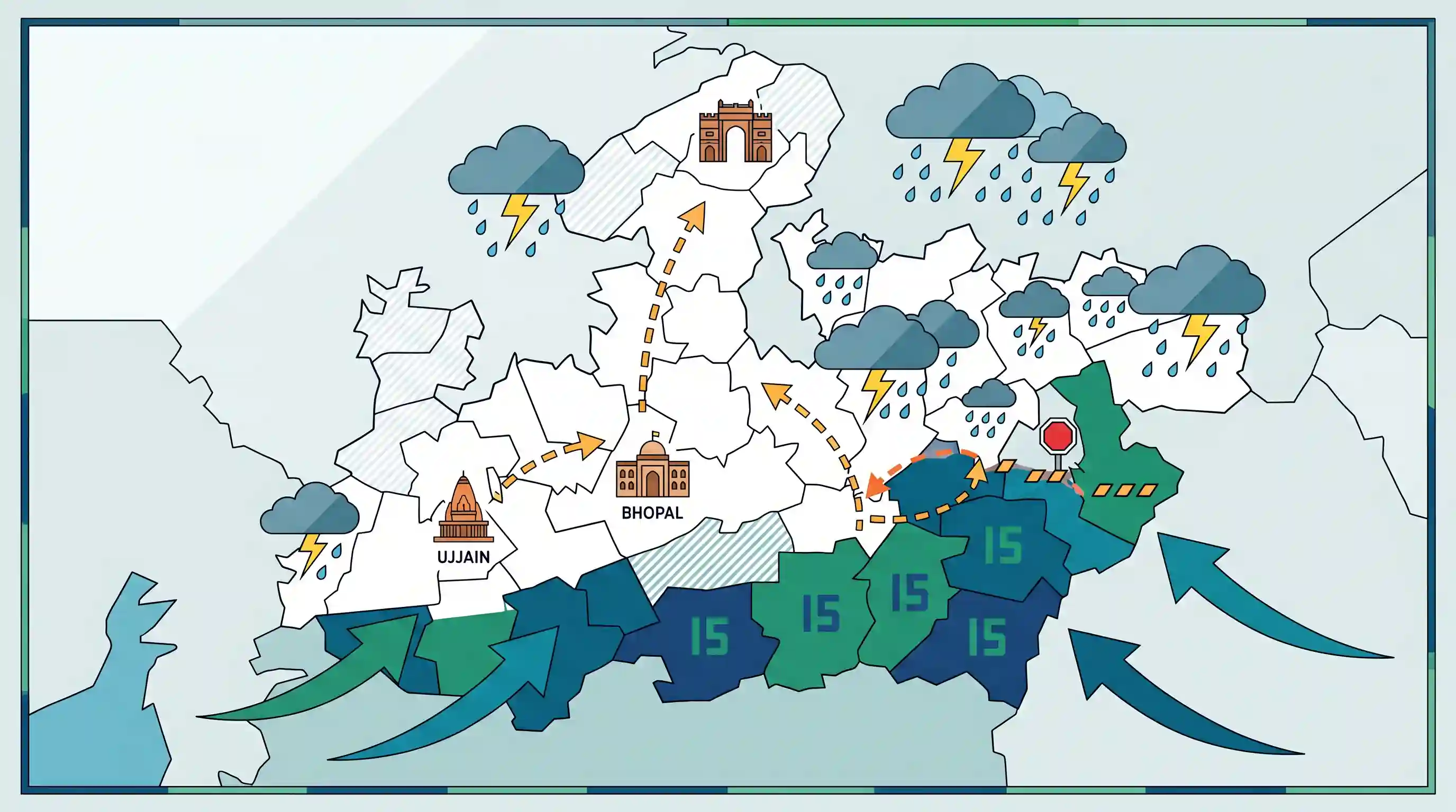
The Southwest monsoon stalled for three days after entering 15 southeastern and southwestern districts of Madhya Pradesh on June 24, 2026. According to the India Meteorological Department (IMD), the monsoon is projected to resume its advance toward the Bhopal and Ujjain divisions before heading to the Gwalior-Chambal region. Meanwhile, active weather systems continue to bring rain and thunderstorms to over 40 districts in the state.
Key Points
- The Southwest monsoon entered Madhya Pradesh on June 24, 2026, covering 15 southern and southeastern districts before stalling for three days.
- The 15 covered districts include Alirajpur, Indore, Harda, Dhar, Betul, Khandwa, Burhanpur, Chhindwara, Pandhurna, Khargone, Seoni, Balaghat, Mandla, Barwani, and Dindori.
- The India Meteorological Department (IMD) expects weather conditions to become favorable for the monsoon to resume and advance into Bhopal and Ujjain divisions, followed by the Gwalior-Chambal region.
- Despite the stall, widespread rain and thunderstorms were forecast for over 40 districts in the state, with lighter showers predicted for northern districts like Datia, Bhind, and Morena.
- Historically, the southeastern region of Madhya Pradesh (including Seoni, Balaghat, and Mandla) receives maximum rainfall from the Bay of Bengal branch of the monsoon.
Important Terms
India Meteorological Department (IMD)

India's primary agency under the Ministry of Earth Sciences, established in 1875 to record meteorological observations, weather forecasting, and issue warning alerts for natural disasters.
UPSC context
GS Paper I (Important Geophysical Phenomena) and GS Paper III (Disaster Management). Tests institutional frameworks for disaster early warnings.
IMD Bhopal
The regional meteorological centre of the IMD in Madhya Pradesh, operating since 1976 to conduct localized weather observation, forecasting, and agromet services.
UPSC context
GS Paper I & State PSC. Tests local meteorological infrastructure, regional climate, and localized early warning systems.
Southwest Monsoon
A seasonal, moisture-laden wind system blowing from the Indian Ocean to the Indian subcontinent from June to September, delivering the majority of the region's annual precipitation.
UPSC context
GS Paper I (Physical Geography). Tests mechanisms of monsoon development, onset, and its crucial impact on Indian agriculture and economy.
Monsoon Break
A temporary dry spell or period of significantly reduced rainfall lasting a few days to weeks during the active phase of the Southwest Monsoon.
UPSC context
GS Paper I (Climatology). Tests understanding of spatial-temporal monsoon variations, the monsoon trough, and impact on crop cycles.
Gwalior-Chambal Region
A geographic region in northern Madhya Pradesh drained by the Chambal River, characterized by semi-arid climate and extensive badland topography consisting of deep ravines.
UPSC context
GS Paper I (Indian Geography). Tests geomorphology, river valley systems, and soil conservation challenges in semi-arid environments.
Prelims Trap
Madhya Pradesh receives its monsoon rainfall exclusively from the Arabian Sea branch due to its geographic proximity to the western coast.
MP is a unique transition zone receiving rainfall from both branches; the southeastern districts get their maximum precipitation specifically from the Bay of Bengal branch.
Static Concepts Connected
How do the two branches of the Southwest Monsoon interact over Central India?
- Arabian Sea Branch: Enters through the Narmada-Tapi rift valleys, bringing rainfall to western and southwestern regions of Madhya Pradesh.
- Bay of Bengal Branch: Sweeps across the Ganga valley, turning southwest to cause heavy rainfall in eastern and southeastern Madhya Pradesh.
- Convergence Zone: The two branches merge over the central highlands and Mahadeo Hills, making Pachmarhi the wettest spot in the state.
What are 'Chaumasa' and 'Mawath' in the context of Central Indian climate?
- Chaumasa: The local term for the four monsoon months (June-September) when MP receives over 85% of its annual rainfall.
- Mawath: Light winter showers triggered by Mediterranean Western Disturbances, crucial for the growth of Rabi crops in northern/western MP.
Cross-Topic Patterns
Monsoon variability + Agro-climatic cropping patterns
Monsoon stalling directly impacts sowing patterns across MP's 11 agro-climatic zones, highlighting the need for climate-resilient crop planning in rainfed soy and cotton tracts.
Western Disturbances + Central India Rabi yield
While monsoons govern Kharif, localized winter 'Mawath' showers act as a crucial water source for Rabi wheat, linking Mediterranean atmospheric dynamics to Indian food security.

Statements on the intersecting zones of Arabian Sea & Bay of Bengal monsoon branches in Central India are highly probable for GS-I.
Linked PYQs · 4
Linked PYQs · 4
- 2024MPPSC_PRELIMSGS1
The south-eastern part of Madhya Pradesh receives maximum rainfall from :
- 2025MPPSC_PRELIMSGS1
Read the following statements regarding the climate of Madhya Pradesh and select the correct answer from the codes given below: 1. Most of the rainfall in the state is received from the monsoon. 2. Wind speed during winters is faster than in summer and rainy seasons. 3. Distance from sea also affects the distribution of monsoon rains in the state. 4. Summer temperature in Pachmarhi is related to the altitude above sea level. Codes:
- 2018MPPSC_PRELIMSGS1
The climate of Madhya Pradesh is
- 2021MPPSC_PRELIMSGS1
Madhya Pradesh has been divided into how many agro climatic zones?
