Madhya Pradesh pre monsoon rainfall deficit and heatwave alert
Source:freepressjournal ↗
Why It Matters
Understanding the onset, regional variation, and economic consequences of the Southwest monsoon in Madhya Pradesh is essential for MPPSC, as the state's agriculture and climatic extremes are frequently asked in the prelims.
Summary
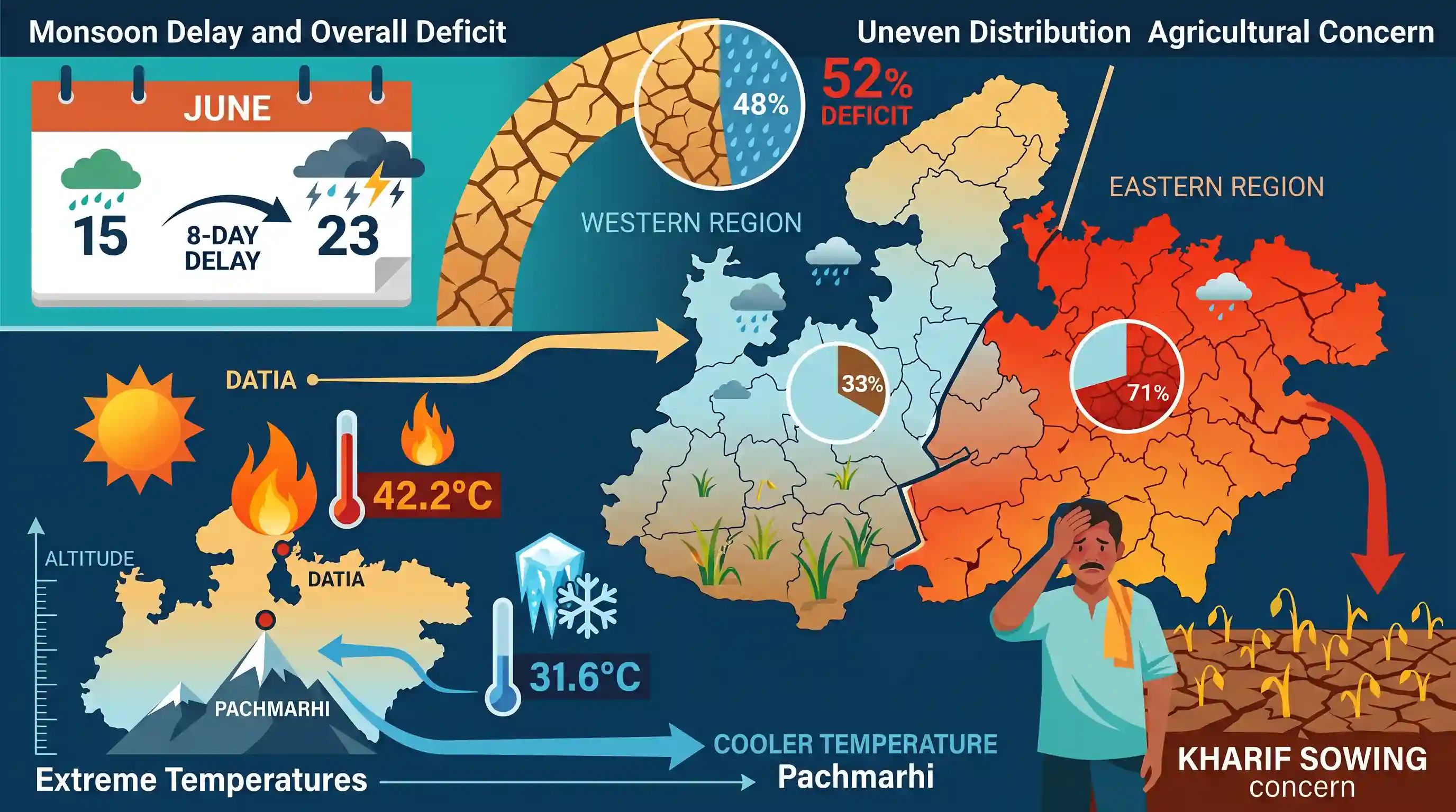
Madhya Pradesh experienced a significant 52% rainfall deficit in June 2026 due to an eight-day delay in the Southwest monsoon, which typically arrives by June 15. The deficit was unevenly distributed, with the eastern region suffering a 71% deficit compared to a 33% deficit in the western region, causing major concerns for Kharif crop sowing. Datia emerged as the hottest district (42.2°C), while Pachmarhi remained the coolest (31.6°C) due to its high altitude.
Key Points
- Monsoon Delay: The Southwest monsoon, which normally enters Madhya Pradesh by June 15, was delayed by approximately eight days in June 2026, leading to an overall 52% deficit in rainfall across the state.
- Regional Disparities in Deficit: The eastern region (consisting of Jabalpur, Rewa, Sagar, and Shahdol divisions) experienced a severe 71% rainfall deficit, while the western region (comprising Bhopal, Indore, Ujjain, Narmadapuram, and Gwalior-Chambal divisions) recorded a 33% deficit.
- Impact on Agriculture: The lack of timely rains has significantly delayed the sowing of Kharif crops, which are heavily dependent on early monsoon precipitation for initial growth.
- Climatic and Temperature Extremes: Datia recorded the state's highest temperature of 42.2°C, aligning with the northern region's typical extreme summer heat. Pachmarhi, a hill station in the Satpura range, recorded the coolest temperature at 31.6°C due to its higher elevation.
Important Terms
India Meteorological Department (IMD)

The principal government agency under the Ministry of Earth Sciences responsible for meteorological observations, weather forecasting, seismology, and issuing early warnings for severe weather events.
UPSC context
GS Paper I: Geography/Climatology; GS Paper III: Disaster Management. Tests agency mandates, forecasting, and early warning systems.
Southwest Monsoon
A seasonal wind system (June to September) driven by temperature differences between land and sea, delivering nearly 75–80% of India's annual rainfall, vital for agriculture and water security.
UPSC context
GS Paper I: Physical Geography (Indian Climate); GS Paper III: Agriculture. Tests knowledge of monsoon mechanisms, spatial variability, and economic impacts.
Kharif Crops
Monsoon-season crops sown in June–July with the onset of the southwest monsoon and harvested in September–October, representing the backbone of India's rain-fed agricultural system.
UPSC context
GS Paper III: Cropping Patterns & Food Security. Tests understanding of crop seasons, climate requirements, and susceptibility to monsoon variability.
Heatwave
A period of abnormally high temperatures exceeding normal maximums, declared by IMD when temperatures cross 40°C in plains (30°C in hills) alongside a standard departure from normal temperatures.
UPSC context
GS Paper III: Disaster Management; GS Paper I: Climatology. Tests understanding of climate change, IMD's declaration criteria, and public health guidelines.
Prelims Trap
Soybean is the primary and most cultivated agricultural crop overall in Madhya Pradesh in terms of production volume and land area.
Aspirants confuse MP's global reputation as the "Soy State" with its actual top crop. Wheat, a Rabi crop, is the overall leader in both acreage and volume.
Static Concepts Connected
How do the Arabian Sea and Bay of Bengal branches of the Southwest Monsoon interact over Central India?
- Convergence Zone: The two branches merge over central India, causing highly volatile and uneven rainfall distribution patterns across Madhya Pradesh.
- Eastern Dominance: Southeastern districts receive intense precipitation predominantly from the Bay of Bengal branch, making it the wettest region.
- Western Depletion: Western districts rely on the Arabian Sea branch, which loses substantial moisture after crossing the Western Ghats.
What geographic factors cause Pachmarhi to be a major climatic outlier in Central India?
- Orographic Lift: The Mahadeo Hills force incoming monsoon winds to rise, causing rapid cooling, condensation, and high orographic precipitation.
- Thermal Regulation: With an altitude exceeding 1,000m, Pachmarhi experiences a montane microclimate, keeping summer temperatures substantially lower than the surrounding plains.
Cross-Topic Patterns
Monsoon delays and macroeconomic inflation
Delayed Kharif sowing of oilseeds (like soybean) and pulses shifts cropping patterns, directly impacting domestic edible oil import dependency and retail food inflation.
Orographic microclimates vs heatwave vulnerability
The temperature contrast between Datia and Pachmarhi highlights how regional forest cover and altitude create microclimates that buffer against extreme heatwaves.

Dual-branch monsoon convergence anomalies and their cascading impact on Kharif oilseed yields are highly probable for GS-1 2026.
Linked PYQs · 4
Linked PYQs · 4
- 2025MPPSC_PRELIMSGS1
Read the following statements regarding the climate of Madhya Pradesh and select the correct answer from the codes given below: 1. Most of the rainfall in the state is received from the monsoon. 2. Wind speed during winters is faster than in summer and rainy seasons. 3. Distance from sea also affects the distribution of monsoon rains in the state. 4. Summer temperature in Pachmarhi is related to the altitude above sea level. Codes:
- 2018MPPSC_PRELIMSGS1
The climate of Madhya Pradesh is
- 2022MPPSC_PRELIMSGS1
Which of the following statements regarding the climate of Madhya Pradesh is not correct?
- 2024MPPSC_PRELIMSGS1
The south-eastern part of Madhya Pradesh receives maximum rainfall from :
