Multiple Districts Face Rainfall Deficit Across Madhya Pradesh
Source:freepressjournal ↗
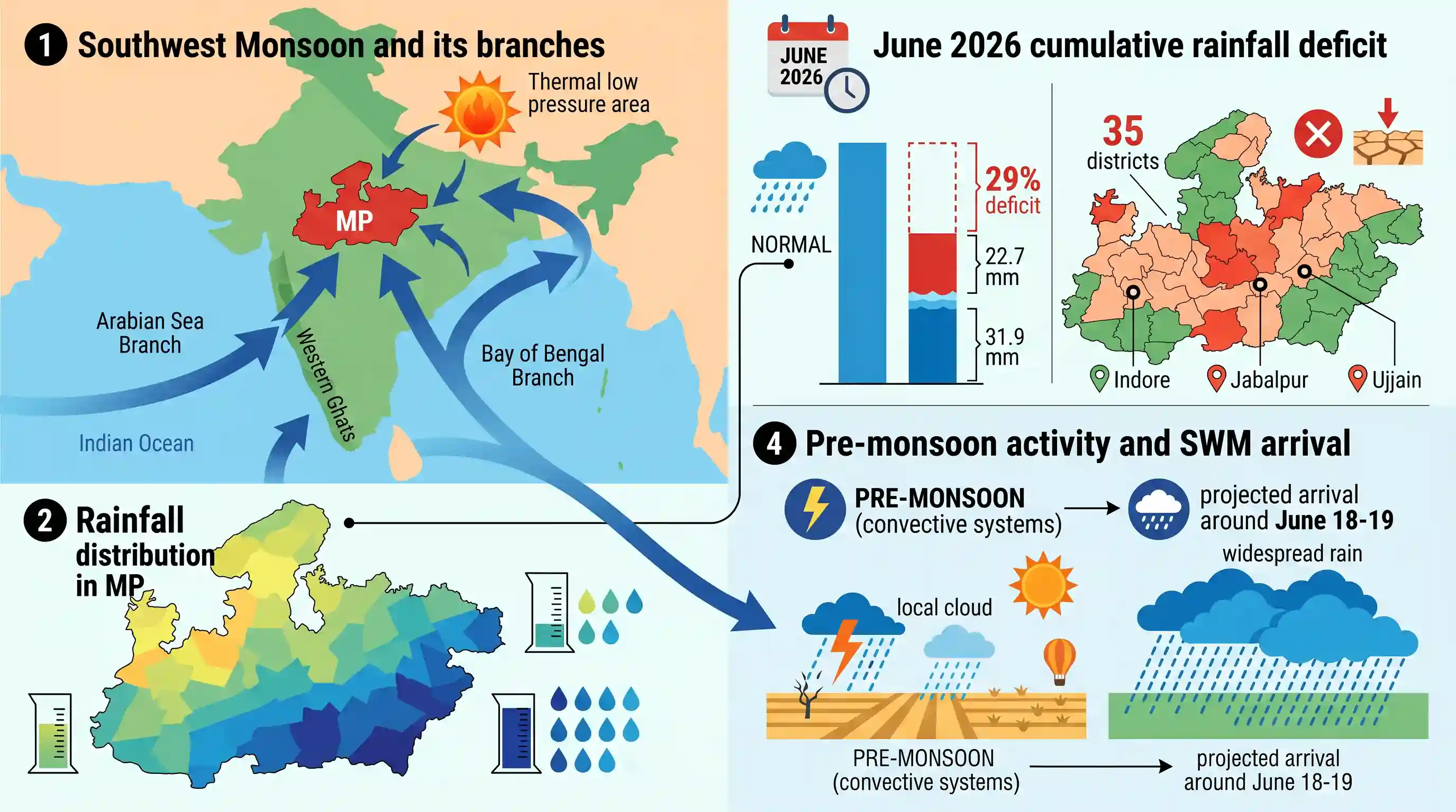
Why It Matters
The temporal and spatial patterns of the southwest monsoon, its onset dates, and the rainfall dynamics between the Arabian Sea and Bay of Bengal branches are recurring areas of focus in the MPPSC State Service Prelims geography syllabus.
Summary
In June 2026, Madhya Pradesh faced a 29% cumulative rainfall deficit in the first half of the month, recording 22.7 mm of rain against the normal 31.9 mm. With 35 districts (including Indore, Jabalpur, and Ujjain) exhibiting deficient rainfall, the state relied primarily on pre-monsoon convective systems prior to the projected arrival of the southwest monsoon around June 18–19. This scenario highlights the geographical and temporal variations of the monsoon climate in Central India.
Key Points
- Madhya Pradesh experienced a significant rainfall deficit of 29% during the first half of June 2026 (June 1 to 15), recording only 22.7 mm of rainfall against the historical normal average of 31.9 mm.
- A total of 35 districts out of the state's districts faced a rain deficit, including Indore, Jabalpur, Ujjain, Chhindwara, Balaghat, Seoni, Dewas, and Dhar, largely due to a reliance on early pre-monsoon convective activity rather than the main monsoon system.
- The India Meteorological Department (IMD) slated the onset of the southwest monsoon in Madhya Pradesh for around June 18–19, 2026, which is consistent with the state's typical mid-June arrival timeline.
- Madhya Pradesh has a tropical monsoon climate (as tested in MPPSC 2018), where over 85% to 90% of its annual precipitation occurs between June and September via the Southwest Monsoon.
- Rainfall distribution in Madhya Pradesh varies significantly; the southeastern region (e.g., Balaghat, Seoni, Mandla) receives its highest rainfall from the Bay of Bengal branch of the monsoon (tested in MPPSC 2024), while western areas (e.g., Indore, Ujjain) lie further from the sea and receive comparatively less rainfall.
Important Terms
India Meteorological Department (IMD)

The principal government agency under the Ministry of Earth Sciences responsible for meteorological observations, weather forecasting, seismology, and issuing early warnings for severe weather events.
UPSC context
GS Paper I (Geography) & GS III (Disaster Management); tests key scientific bodies, forecast mechanisms, and disaster mitigation frameworks.
Southwest Monsoon
The seasonal wind system blowing from sea to land (June–September) that delivers nearly 75% of India's annual precipitation, driven by thermal contrasts.
UPSC context
GS Paper I (Physical Geography); tests atmospheric mechanisms, regional precipitation distribution, and macroeconomic dependence on seasonal rainfall.
Long Period Average (LPA)
The 50-year historical average of seasonal rainfall used as a baseline benchmark by the IMD to evaluate and classify monsoon performance.
UPSC context
GS Paper I (Geography) & GS III (Agriculture); tests quantitative metrics used in monsoon tracking and crop sowing planning.
Convectional Rainfall
Precipitation generated when strong solar heating forces warm, moist air to rise vertically, cool adiabatically, and condense into localized cumulonimbus clouds.
UPSC context
GS Paper I (Physical Geography); tests understanding of precipitation types, local pre-monsoon winds, and global climatic zones.
Deficient Rainfall
An IMD classification indicating that seasonal or periodic rainfall in an area is 20% to 59% lower than the corresponding Long Period Average.
UPSC context
GS Paper I (Geography) & GS III (Agriculture); tests drought classification, irrigation challenges, and agricultural vulnerability.
Prelims Trap
Western districts of Madhya Pradesh receive higher rainfall than eastern districts due to closer proximity to the Arabian Sea.
Rainfall actually decreases from east to west in MP. The southeastern region receives the highest rainfall (often exceeding 140 cm) due to active Bay of Bengal branch winds.
Static Concepts Connected
How do the dual branches of the Southwest Monsoon interact over Central India?
- Branch convergence: The Arabian Sea and Bay of Bengal branches merge over Central India, leading to high-intensity precipitation during July and August.
- Sourced distribution: Southeastern MP receives heavy rainfall primarily from the Bay of Bengal branch, while western parts receive moderate showers from the Arabian Sea branch.
- Gradient effect: Rainfall decreases progressively from the south-east/east toward the north-west/west due to increasing distance from maritime moisture sources.
What geographical factors moderate Pachmarhi's unique microclimate?
- Orographic moderation: Situated in the Mahadeo Hills of the Satpura Range, its high altitude (approx 1,067m) keeps summers significantly cooler than surrounding plains.
- High precipitation: Its location causes incoming monsoon winds to rise abruptly, resulting in the state's highest average annual rainfall (over 200 cm).
Cross-Topic Patterns
Monsoon deficit + Kharif crop economics
Delayed or deficit June rainfall in Central India disrupts the crucial kharif sowing window for oilseeds like soybean, directly impacting retail food inflation and rural consumption patterns.
ENSO dynamics + Central India weather
The temporal delay in central India's monsoon onset is frequently linked to lingering El Niño effects or negative Indian Ocean Dipole phases, highlighting ocean-atmosphere coupling.

Dual-branch monsoon convergence and rainfall gradients across the Satpura-Vindhyan systems will likely feature in physical geography.
Linked PYQs · 3
Linked PYQs · 3
- 2018MPPSC_PRELIMSGS1
The climate of Madhya Pradesh is
- 2025MPPSC_PRELIMSGS1
Read the following statements regarding the climate of Madhya Pradesh and select the correct answer from the codes given below: 1. Most of the rainfall in the state is received from the monsoon. 2. Wind speed during winters is faster than in summer and rainy seasons. 3. Distance from sea also affects the distribution of monsoon rains in the state. 4. Summer temperature in Pachmarhi is related to the altitude above sea level. Codes:
- 2024MPPSC_PRELIMSGS1
The south-eastern part of Madhya Pradesh receives maximum rainfall from :
