Monsoon Covers Entire Madhya Pradesh as IMD Issues Heavy Rain Alerts
Source:freepressjournal ↗
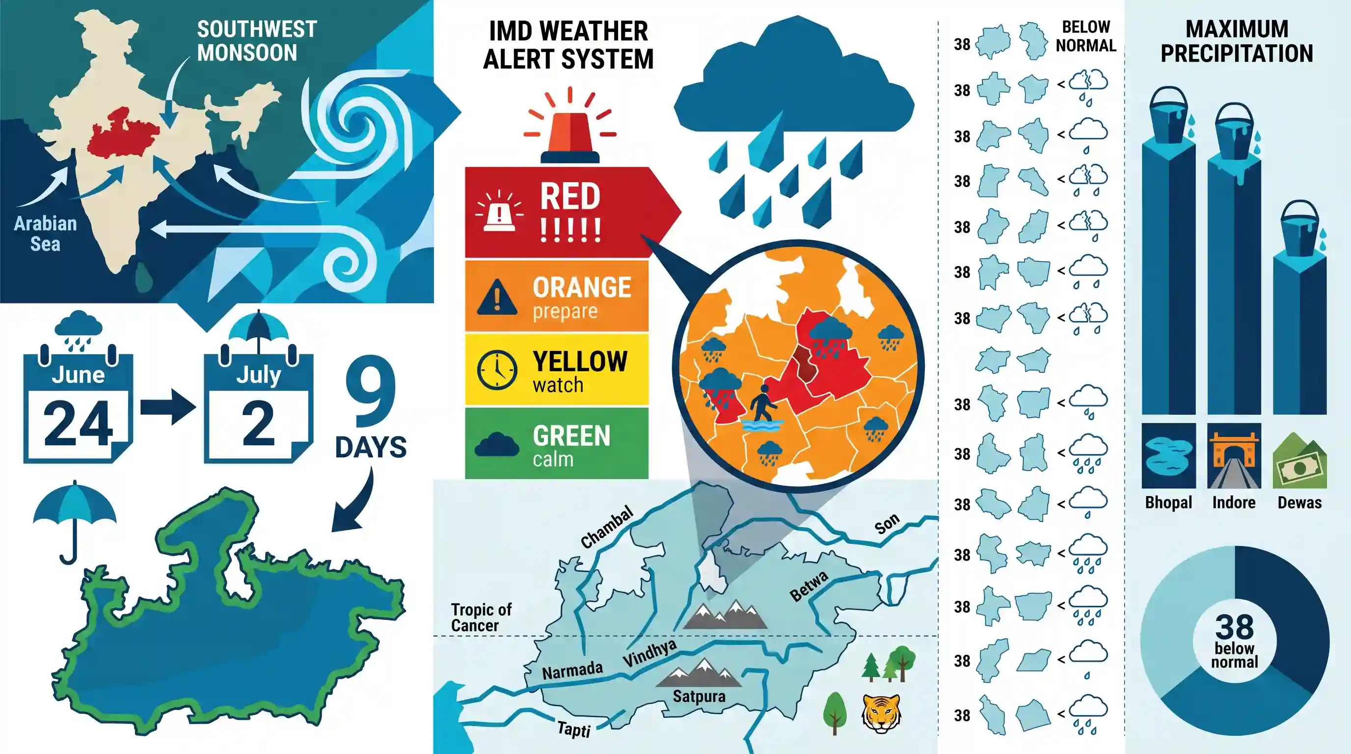
Why It Matters
MPPSC Prelims regularly features questions on Madhya Pradesh's climatology, including rainfall distribution across different divisions, the impact of the Arabian Sea and Bay of Bengal monsoon branches, temperature variation factors (e.g., elevation), and agro-climatic zones. Staying updated with real-time monsoon advancement and IMD alert terminology is highly relevant.
Summary
By July 2, 2026, the Southwest Monsoon fully covered the state of Madhya Pradesh within nine days of its arrival on June 24. Marking the season's first major warning, the India Meteorological Department (IMD) issued a 'Red Alert' for extremely heavy rain in Khandwa and Harda, with multiple other districts predicted to get heavy downpours. Although the monsoon has spanned the entire geography, 38 districts are experiencing below-normal rainfall, while Bhopal, Indore, and Dewas have recorded the maximum precipitation.
Key Points
- Monsoon Coverage: The Southwest Monsoon entered Madhya Pradesh on June 24, 2026, and covered the entire state by July 2, 2026, within nine days, completing its reach through the remaining districts of Ujjain, Gwalior, and Chambal divisions.
- First Red Alert of the Season: IMD Bhopal issued a 'Red Alert' for Khandwa and Harda districts warning of extremely heavy rainfall. Districts such as Dhar, Barwani, Khargone, Dewas, Burhanpur, and Betul are expected to get 4 to 8 inches of rain within 24 hours.
- Rainfall Variation: Despite complete geographical coverage, 38 districts in the state are reporting below-normal rainfall. Bhopal, Indore, and Dewas are leading with the highest recorded rainfall this season.
- IMD Weather Alert Color Codes: Green (no warning/no action), Yellow (be aware/watch), Orange (be prepared/alert), and Red (take action/warning) are the color-coded signals used by the IMD to forecast hazardous weather severity.
- MP Climate & Monsoon Branches: Madhya Pradesh's climate is tropical monsoon. Most of its rainfall is received from the Southwest Monsoon. The southeastern part of MP receives the maximum rainfall, heavily influenced by the Bay of Bengal branch, whereas the western parts rely more on the Arabian Sea branch. Distance from the sea plays a significant role in precipitation distribution.
Important Terms
India Meteorological Department (IMD)

The principal government agency under the Ministry of Earth Sciences responsible for meteorological observations, weather forecasting, seismology, and early warnings for weather-related hazards in India.
UPSC context
GS Paper I (Geography) & III (Disaster Management); tests administrative mandates and early-warning institutional frameworks.
Southwest Monsoon
The dominant summer rainy season in India (June-September), driven by differential heating between land and ocean, delivering nearly 75% of the country's annual rainfall.
UPSC context
GS Paper I (Physical Geography); tests understanding of monsoon mechanisms, onset, and its critical agrarian socio-economic impacts.
Red Alert (IMD)
The highest color-coded weather warning issued by the IMD, signifying extremely severe weather expected to cause high risk, prompting authorities and citizens to take immediate action.
UPSC context
GS Paper III (Disaster Management); tests knowledge of emergency warning protocols, impact-based forecasting, and mitigation strategies.
Prelims Trap
An IMD 'Red Alert' represents a legally binding directive that automatically mandates district authorities to initiate evacuations.
IMD warnings are purely advisory scientific forecasts. Evacuation orders and administrative responses are legally executed by State or District Disaster Management Authorities, not the IMD itself.
Static Concepts Connected
What are the operational meanings of IMD's color-coded weather alerts?
- Green (No Action): Indicates normal meteorological conditions; no warning is issued and no coordination action is required.
- Yellow (Be Aware): Signals deteriorating weather; authorities must keep watch and track updates for potential localized hazards.
- Orange (Be Prepared): Warns of severely bad weather with potential transport and power disruptions; authorities must prepare contingency plans.
- Red (Take Action): Warns of extremely severe weather with high risk to life and infrastructure; requires immediate rescue and response coordination.
How do the two branches of the Southwest Monsoon interact over Central India?
- Arabian Sea Branch: Enters via the west coast; its second branch strikes the Narmada-Tapti rift valley, carrying moisture directly into central India.
- Bay of Bengal Branch: Enters via Bengal, is deflected westwards by the Himalayas, and travels along the Indo-Gangetic plains toward the northwest.
- Convergence Dynamics: Both branches converge over the northern and central Indian plains, creating low-pressure troughs that trigger intense, widespread monsoon downpours.
Cross-Topic Patterns
Extreme Rain + Urban Infrastructure
Instantaneous heavy downpours test municipal drainage limits, showing why Sponge City infrastructure is critical to prevent urban flooding in rapidly expanding tier-2 central Indian cities.
Monsoon Deficits + Farm Economics
Spatial rainfall deficits despite complete geographic monsoon coverage mask micro-level crop stress, complicating Kharif sowing, crop insurance payouts, and food inflation forecasting.

IMD's impact-based forecasting and the dual-branch monsoon convergence over Central India remain high-yield areas for Prelims 2026.
Linked PYQs · 3
Linked PYQs · 3
- 2024MPPSC_PRELIMSGS1
The south-eastern part of Madhya Pradesh receives maximum rainfall from :
- 2025MPPSC_PRELIMSGS1
Read the following statements regarding the climate of Madhya Pradesh and select the correct answer from the codes given below: 1. Most of the rainfall in the state is received from the monsoon. 2. Wind speed during winters is faster than in summer and rainy seasons. 3. Distance from sea also affects the distribution of monsoon rains in the state. 4. Summer temperature in Pachmarhi is related to the altitude above sea level. Codes:
- 2021MPPSC_PRELIMSGS1
Madhya Pradesh has been divided into how many agro climatic zones?
