Madhya Pradesh Monsoon Rainfall Deficit and Dry Spell Analysis
Source:freepressjournal ↗
Why It Matters
Understanding regional rainfall distribution, monsoon patterns, and meteorological shifts like 'break monsoon' is a core part of the physical and regional geography of Madhya Pradesh, which is regularly tested in MPPSC State Service Prelims exams.
Summary
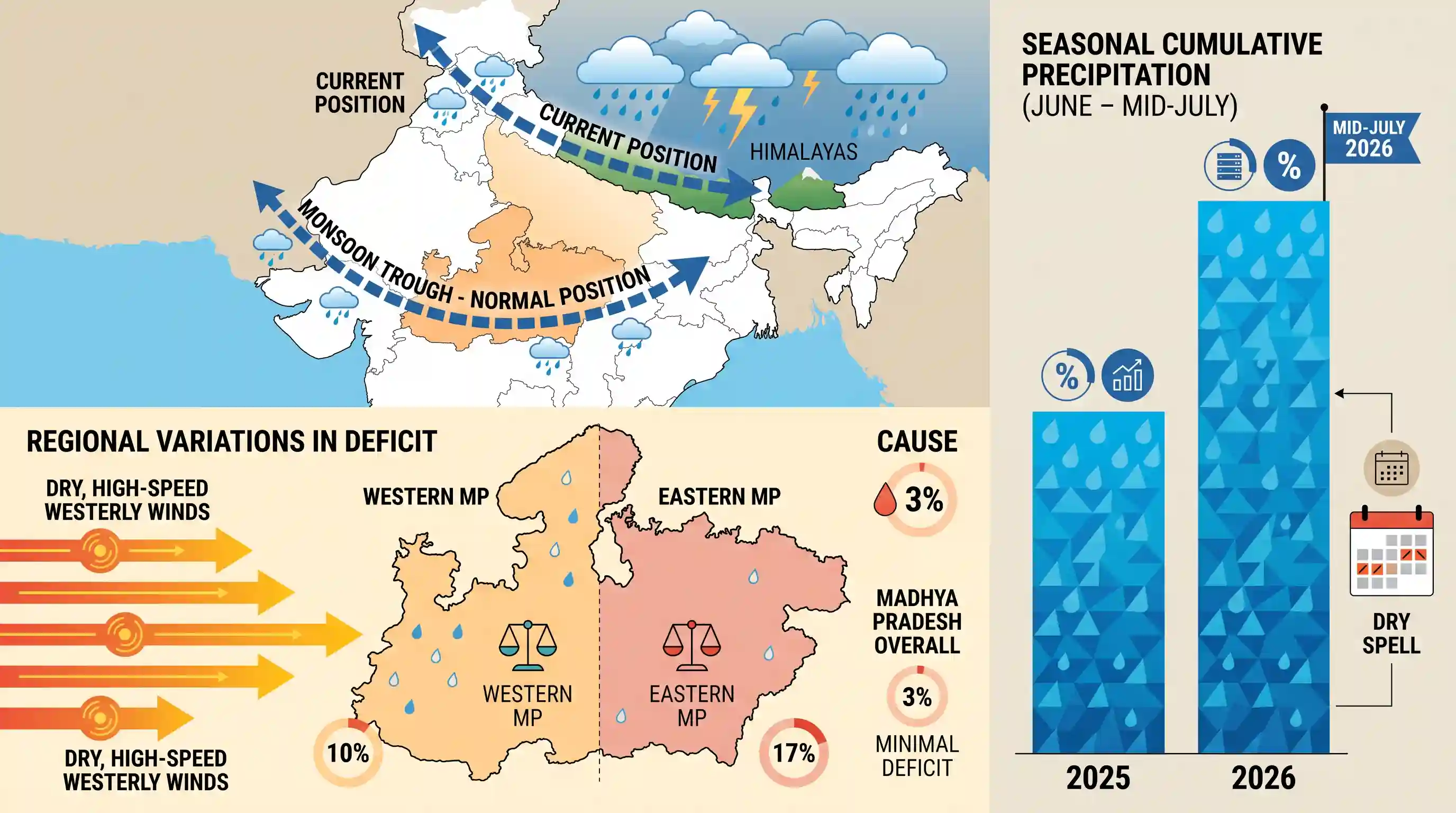
A sudden five-day dry spell in mid-July 2026 has pushed Madhya Pradesh into a 3% overall rainfall deficit as the southwest monsoon temporarily weakened. This lull is caused by the northward movement of the monsoon trough toward the Himalayan foothills, allowing dry, high-speed westerly winds to prevail across the state. Eastern MP faces a higher deficit (17%) than Western MP (10%). However, overall seasonal cumulative precipitation remains significantly higher than the corresponding period in 2025.
Key Points
- Madhya Pradesh recorded a 3% overall rainfall deficit by mid-July 2026 after a five-day rain-free dry spell across the state.
- The state received 241.8 mm (9.5 inches) of rainfall so far, compared to the normal average of 250.1 mm (9.8 inches) for this period.
- Regional analysis shows Eastern MP (Jabalpur, Shahdol, Sagar, and Rewa divisions) has a 17% deficit, while Western MP (Bhopal, Indore, Ujjain, Narmadapuram, and Gwalior-Chambal divisions) has a 10% deficit.
- The meteorological cause is the shifting of the monsoon trough towards the Himalayan foothills, inducing a break-monsoon phase dominated by dry westerly winds gusting up to 50 km/h.
- Despite the current dry spell, the cumulative rainfall from June 1 to July 13 is significantly higher than that of 2025; for instance, Indore district recorded 13.9 inches of average rain in 2026 compared to 6.2 inches in 2025.
Important Terms
Southwest Monsoon

A major summer wind system blowing from the southwest Indian Ocean, bringing nearly 75% of India's annual rainfall between June and September.
UPSC context
GS Paper I (Geography). Tests core climatological mechanisms of wind reversal and its socio-economic impacts on Indian agriculture.
Monsoon Trough
An elongated low-pressure area over the Indo-Gangetic plains representing the northward-shifted Inter-Tropical Convergence Zone (ITCZ), key to driving Indian monsoon precipitation.
UPSC context
GS Paper I (Climatology). Tests concepts of low-pressure belts, seasonal wind shift systems, and rainfall distribution patterns.
Break in Monsoon
A dry phase during the rainy season where monsoon rains cease or weaken significantly over central India due to the northward movement of the monsoon trough.
UPSC context
GS Paper I (Climatology). Tests knowledge of intraseasonal monsoon fluctuations, active-break cycles, and regional microclimatic variations.
India Meteorological Department (IMD)
The principal government agency under the Ministry of Earth Sciences overseeing meteorological observations, weather forecasting, seismology, and natural disaster warnings.
UPSC context
GS Paper I (Geography) & GS Paper III (Disaster Management). Tests institutional frameworks for disaster management and climate forecasting.
Prelims Trap
A 'break' phase in the Southwest Monsoon causes a uniform, country-wide cessation of precipitation.
During a break phase, rainfall does not stop everywhere. While the plains experience dry conditions, the Himalayan foothills and Northeast India experience heavy to extreme rainfall, often leading to floods.
Static Concepts Connected
What is the 'Break in the Monsoon' phenomenon and its meteorological drivers?
- Trough Shift: Occurs when the low-pressure monsoon trough shifts northwards from its normal position to the Himalayan foothills.
- Spatial Contrast: Rainfall ceases over central and northern plains but increases significantly over the Himalayan foothills and Northeast India.
- Westerly Winds: Warm, dry westerly winds dominate the plains, temporarily halting the moist monsoonal flow.
How do the Arabian Sea and Bay of Bengal branches of the Southwest Monsoon interact over Central India?
- Arabian Sea Branch: Enters Central India through the Narmada and Tapti valleys, primarily bringing rain to Western Madhya Pradesh.
- Bay of Bengal Branch: Moves up the Ganges plains, bringing heavy, moisture-laden precipitation to Eastern and Southeastern Madhya Pradesh.
- Convergence Zone: The two branches meet near the Maikal Range, creating a high-rainfall zone in southeastern MP.
Cross-Topic Patterns
Monsoon breaks + Kharif crop cycles
Mid-July dry spells disrupt the critical transplantation window of water-intensive Kharif crops like paddy and soybean in Central India, impacting food prices and agricultural GDP.
Trough migration + Mountain disasters
The northward shift of the monsoon trough that causes dry spells in MP simultaneously triggers extreme precipitation, flash floods, and landslides in the Himalayas.

Expect a multi-statement conceptual question on the spatial distribution of rainfall during active vs. break phases of the monsoon.
Linked PYQs · 4
Linked PYQs · 4
- 2025MPPSC_PRELIMSGS1
Read the following statements regarding the climate of Madhya Pradesh and select the correct answer from the codes given below: 1. Most of the rainfall in the state is received from the monsoon. 2. Wind speed during winters is faster than in summer and rainy seasons. 3. Distance from sea also affects the distribution of monsoon rains in the state. 4. Summer temperature in Pachmarhi is related to the altitude above sea level. Codes:
- 2024MPPSC_PRELIMSGS1
The south-eastern part of Madhya Pradesh receives maximum rainfall from :
- 2023MPPSC_PRELIMSGS1
Which of the following statements is not correct regarding the climate of Madhya Pradesh?
- 2018MPPSC_PRELIMSGS1
The climate of Madhya Pradesh is
