NISAR Satellite Mission Applications in Earth Observation and Space
Source:Indian Express ↗
Why It Matters
NISAR is one of the most advanced and expensive Earth-observation satellites ever developed, showcasing significant technological advancements in Synthetic Aperture Radar (SAR). It is highly relevant for UPSC aspirants due to its direct applications in remote sensing (GS-3 S&T), climate and environmental monitoring (GS-3 Environment), and disaster risk reduction (GS-3 Disaster Management). Additionally, it highlights the deepening strategic and scientific cooperation between India and the US.
Summary
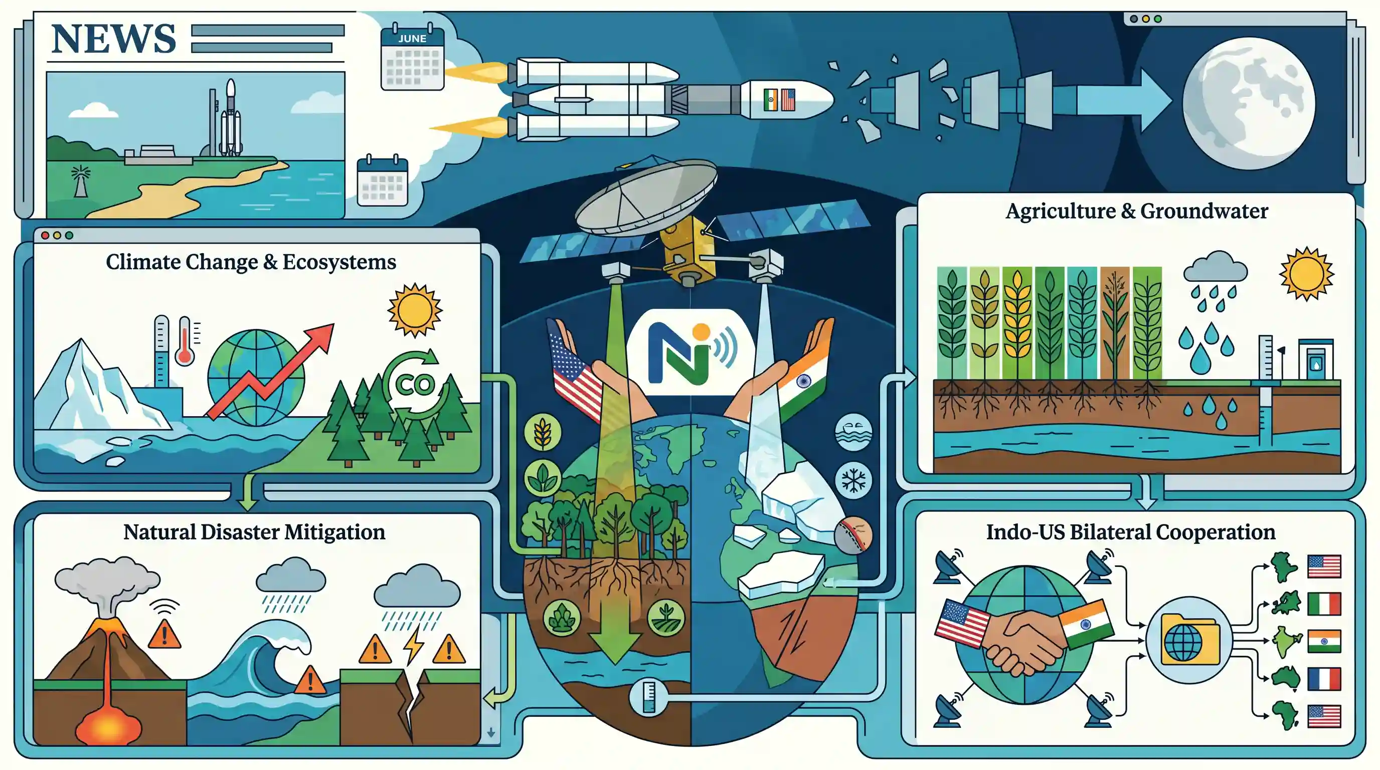
The long-delayed NASA-ISRO Synthetic Aperture Radar (NISAR) mission is expected to finally launch in June aboard ISRO's GSLV Mk II. As a joint Earth-observation endeavor, NISAR is equipped with advanced L-band and S-band radar payloads to monitor the planet's ecosystems, ice coverage, and crustal deformation. The mission will generate critical open-source data to aid global efforts in climate change tracking, agriculture planning, groundwater management, and natural disaster mitigation. It stands as a major milestone in bilateral space cooperation between India and the United States.
Key Points
- NISAR (NASA-ISRO Synthetic Aperture Radar) is a collaborative Earth-observation satellite featuring advanced dual-frequency (L-band and S-band) radar imaging.
- The mission is designed to track Earth's changing ecosystems, dynamic surfaces, and ice masses, providing vital data for climate change studies and biomass tracking.
- NISAR's applications extend to disaster management by monitoring natural hazards such as earthquakes, tsunamis, and landslides, as well as tracking groundwater and sea-level rise.
- Following multiple delays, the mission is now expected to launch in June aboard ISRO's Geosynchronous Satellite Launch Vehicle (GSLV) Mk II.
Important Terms
NISAR Mission

A joint Earth-observation satellite mission by NASA and ISRO using dual-frequency radar to monitor global environmental changes, including crustal deformation, ice-sheet melt, and ecosystem shifts.
UPSC context
GS Paper III (Science & Technology/Environment); crucial for understanding Indo-US space cooperation and advanced remote sensing applications.
Synthetic Aperture Radar (SAR)
A remote sensing technology that uses radar pulses to create high-resolution 2D or 3D images of landscapes, capable of operating through clouds, darkness, and rain.
UPSC context
GS Paper III; technical understanding of satellite imaging for disaster management and climate monitoring.
GSLV Mk II
ISRO's medium-lift three-stage launch vehicle featuring an indigenous Cryogenic Upper Stage, used for placing satellites into Geosynchronous or Sun-Synchronous orbits.
UPSC context
GS Paper III; tests knowledge of India's launch capabilities and indigenous cryogenic technology development.
L-band and S-band
Specific microwave frequencies used in NISAR; L-band (NASA) penetrates deep vegetation and soil, while S-band (ISRO) is optimized for surface features like crops and wetlands.
UPSC context
GS Paper III; assesses understanding of radar applications in agriculture, forestry, and geology.
iCET (Initiative on Critical and Emerging Technology)
A bilateral framework to expand strategic technology partnership and defense industrial cooperation between India and the U.S., encompassing space, AI, and semiconductors.
UPSC context
GS Paper II (International Relations); key for analyzing Indo-US strategic ties and tech diplomacy.
Earth Observation (Remote Sensing)
The process of obtaining information about Earth's surface from a distance, typically via satellites, to monitor land use, natural disasters, and environmental changes.
UPSC context
GS Paper III; fundamental for questions on resource management, urban planning, and disaster mitigation.
Prelims Trap
NISAR will be placed in a geosynchronous orbit since it is launched by the GSLV Mk II.
Despite using the Geosynchronous Satellite Launch Vehicle (GSLV) due to its heavy weight, NISAR is an Earth Observation satellite destined for a Low Earth Orbit (SSPO).
Static Concepts Connected
How do Active and Passive remote sensing satellites differ?
- Active Sensors: Emit their own energy (e.g., Synthetic Aperture Radar). They can operate 24/7 and image Earth's surface through clouds, smoke, and complete darkness.
- Passive Sensors: Detect natural sunlight or thermal radiation reflected by the Earth. They are hindered by adverse weather conditions, cloud cover, and nighttime.
Why use GSLV for Sun-Synchronous Polar Orbits (SSPO)?
- PSLV Capacity Limits: ISRO typically uses PSLV for SSPO missions, but its payload capacity caps at around 1,750 kg for these specific orbits.
- GSLV Heavy Lifting: GSLV Mk II handles heavier payloads for LEO/SSPO. NISAR's massive 2,800 kg weight necessitates the GSLV despite the low-earth destination.
Cross-Topic Patterns
Space Tech + Groundwater Management
NISAR's InSAR technology tracks land subsidence in millimeter scales, offering a direct satellite-based tool for monitoring rapid groundwater depletion, aquifer sinking, and structural stability of large dams.
NISAR & the iCET Framework
This mission operationalizes the Indo-US Initiative on Critical and Emerging Technology (iCET), bridging GS3 Space Tech with GS2 Bilateral Relations and open-source data sharing.

Expect a 2026 Prelims multi-statement question mixing NISAR's orbital mismatch (SSPO via GSLV) with its L/S-band canopy penetration traits.
Linked PYQs · 3
Linked PYQs · 3
- 2019PrelimsGS1
For the measurement/estimation of which of the following are satellite images/remote sensing data used? 1. Chlorophyll content in the vegetation of a specific location 2. Greenhouse gas emissions from rice paddies of a specific location 3. Land surface temperatures of a specific location Select the correct answer using the code given below.
- 2015PrelimsGS1
In which of the following activities are Indian Remote Sensing (IRS) satellites used? 1. Assessment of crop productivity 2. Locating groundwater resources 3. Mineral exploration 4. Telecommunications 5. Traffic studies Select the correct answer using the code given below.
- 2018PrelimsGS1
With reference to India's satellite launch vehicles, consider the following statements: 1. PSLVs launch the satellites useful for Earth resources monitoring whereas GSLVs are designed mainly to launch communication satellites. 2. Satellites launched by PSLV appear to remain permanently fixed in the same position in the sky, as viewed from a particular location on Earth. 3. GSLV Mk III is a four-staged launch vehicle with the first and third stages using solid rocket motors; and the second and fourth stages using liquid rocket engines. Which of the statements given above is/are correct?
