Pithoragarh landslide destroys bridge on Kailash Mansarovar route
Source:garhwal-post ↗
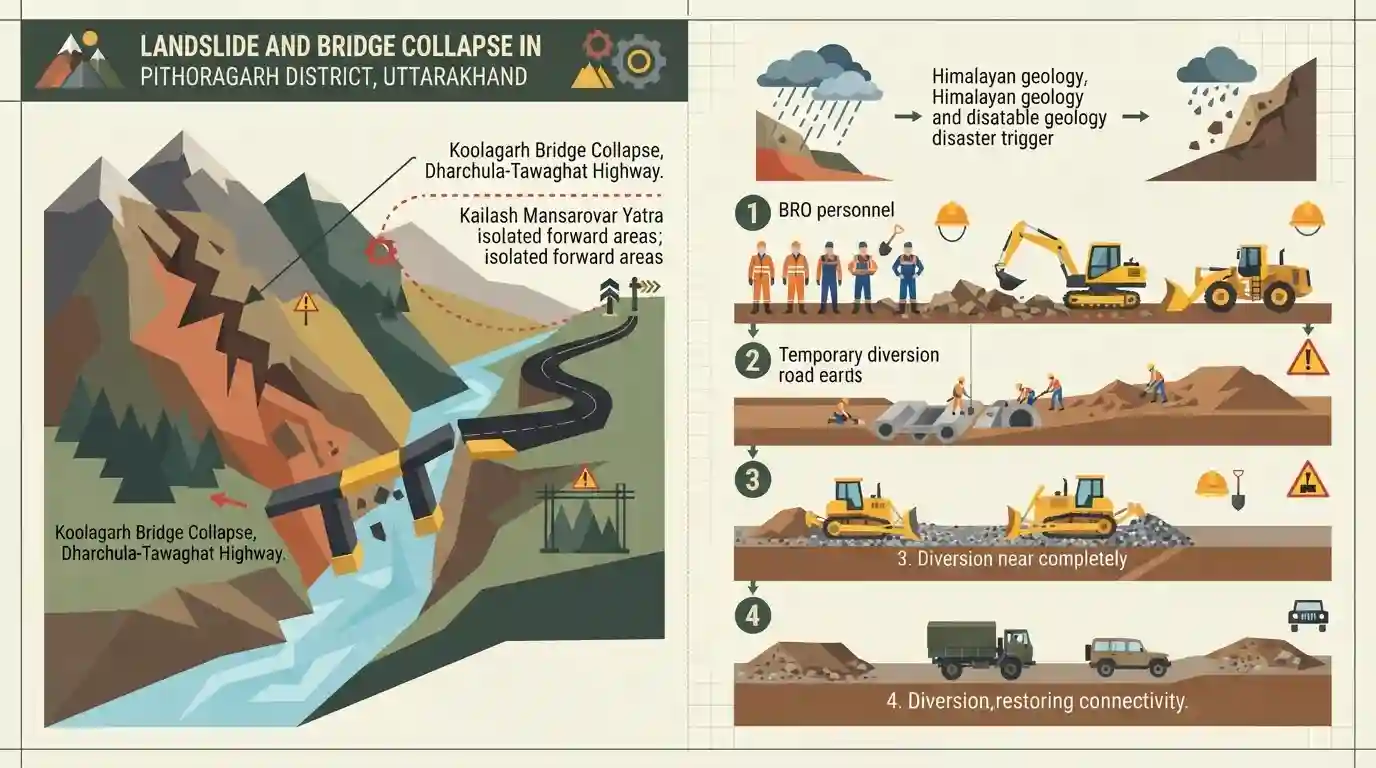
Why It Matters
Highlights the high vulnerability of Himalayan infrastructure to geological hazards like landslides, significantly impacting both strategic border connectivity and major pilgrimage routes in Uttarakhand.
Summary
A massive landslide in Uttarakhand's Pithoragarh district led to the collapse of the Koolagarh bridge on the Dharchula-Tawaghat National Highway, disrupting traffic on the strategically important Kailash Mansarovar Yatra route and isolating forward border areas. The Border Roads Organisation (BRO) is currently working to construct a diversion to restore vehicular movement.
Key Points
- A massive landslide triggered the collapse of the Koolagarh bridge on the Dharchula-Tawaghat National Highway in Pithoragarh district.
- The collapse has severely disrupted the strategically significant Kailash Mansarovar Yatra route and cut off access to forward border areas.
- The Border Roads Organisation (BRO) is actively working to establish a diversion to restore light vehicular traffic.
- Kumaon Mandal Vikas Nigam (KMVN) personnel are involved in providing logistical support to pilgrims traversing the route.
Important Terms
Kailash Mansarovar Yatra

An annual pilgrimage to Mount Kailash and Lake Mansarovar in Tibet, organized by the Ministry of External Affairs. It traverses high-altitude Himalayan routes like Uttarakhand's Lipulekh Pass and Sikkim's Nathu La.
UPSC context
Relevant for GS Paper 1 (Culture, Geography) and GS Paper 2 (India-China bilateral relations and border diplomacy).
Border Roads Organisation (BRO)
A statutory body under the Ministry of Defence tasked with developing and maintaining strategic road networks in India's border areas and friendly neighboring nations.
UPSC context
Essential for GS Paper 3 (Security, Border Management) and GS Paper 2 (International Relations).
Kumaon Mandal Vikas Nigam (KMVN)
A Uttarakhand state government enterprise responsible for tourism, industry, and economic development in the Kumaon region. It manages logistics for the Kailash Mansarovar Yatra along the Lipulekh route.
UPSC context
Important for GS Paper 3 (Regional Development) and understanding state-level institutional roles in managing international pilgrimages.
Dharchula-Tawaghat National Highway
A strategic Himalayan road in Uttarakhand's Pithoragarh district connecting forward border areas and serving as a primary route for the Kailash Mansarovar Yatra. It is highly susceptible to landslides.
UPSC context
Highlights themes in GS Paper 3 (Infrastructure, Disaster Management in the Himalayas) and strategic border connectivity.
Prelims Trap
"The Dhauliganga river meeting the Kali at Tawaghat is the same river that joins the Alaknanda at Vishnuprayag."
Uttarakhand has two distinct Dhauliganga rivers. Tawaghat is at the confluence of the Kali and the Eastern Dhauliganga. The Western Dhauliganga is in Garhwal, joining the Alaknanda at Vishnuprayag.
Static Concepts Connected
What are the key confluences of the Kali River system in Pithoragarh?
- Origin: Rises at Kalapani near the Lipulekh pass, forming the natural eastern border between Uttarakhand and Nepal.
- Tawaghat Confluence: The Kali river meets the Eastern Dhauliganga here, making it a critical geographical and transit node on the Kailash Mansarovar route.
- Jauljibi Confluence: The Kali merges with the Goriganga river here, a location famous for its historic annual commercial and cultural fair.
What is the mandate and administrative control of the Border Roads Organisation (BRO)?
- Defence Ministry: Functions exclusively under the Ministry of Defence (since 2015, shifted from MoRTH) to develop and maintain strategic border infrastructure.
- Project Shivalik: This is BRO's dedicated project responsible for constructing and maintaining critical road networks, including the Kailash Mansarovar route, within Uttarakhand.
Cross-Topic Patterns
Border Roads + India-Nepal Relations
The Dharchula-Lipulekh road is strategically vital but remains a geopolitically sensitive zone due to the historical Kalapani-Vyas Valley territorial map disputes between India and Nepal.
Himalayan Geology + Infrastructure
Frequent landslides in Pithoragarh highlight the ongoing friction between strategic border road construction and the fragile Himalayan ecology near the highly active Main Central Thrust (MCT).

Expect geographical matching questions pairing Kumaon river confluences (like Tawaghat, Jauljibi) with their respective joining rivers.
Linked PYQs · 3
Linked PYQs · 3
- 2011UKPSC_PRELIMSGS1
A visa is required for Kailash Mansarovar pilgrimage because it is located in
- 2024UKPSC_PRELIMSGS1
The train for Manaskhand Corridor Yatra was proposed to start from which railway station ?
- 2025UKPSC_PRELIMSGS1
Which of the following parts of Himalaya is situated between Main Boundary Thrust and Main Central Thrust ?
