Kerala Monsoons: IMD Red Alerts and Western Ghats Flash Floods
Source:The Hindu ↗
Why It Matters
Understanding the mechanisms of the Southwest Monsoon, the significance of lower-tropospheric westerlies, and the IMD's colour-coded warning system are fundamental for UPSC Geography and Disaster Management. The repeated instances of extreme weather events in the Western Ghats region also highlight vulnerabilities that require robust disaster mitigation strategies.
Summary
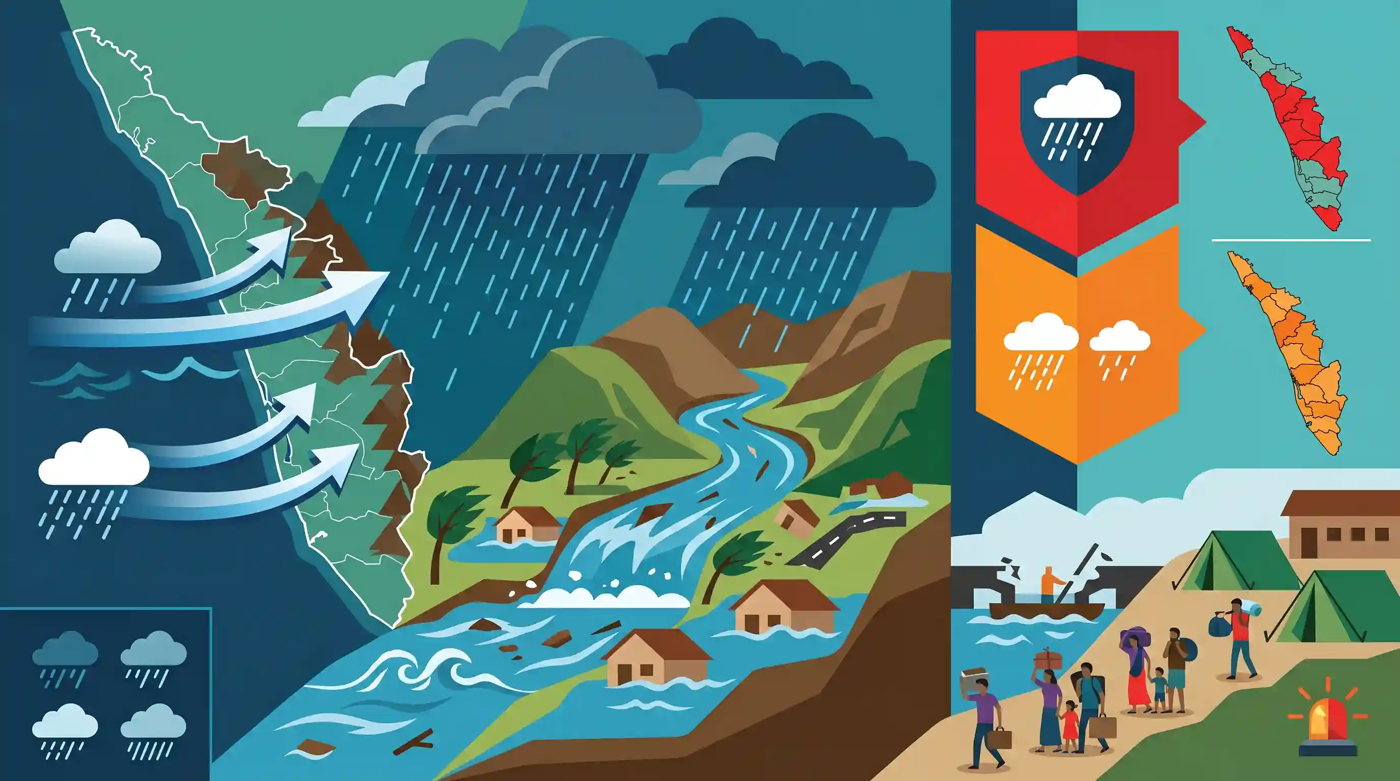
Heavy rainfall accompanied by strong winds, driven by lower-tropospheric westerlies, has caused widespread disruption and flash floods in parts of central and north Kerala. In response, the India Meteorological Department (IMD) has issued a red alert for Kasaragod, Kannur, and Wayanad, and an orange alert for Kozhikode, Malappuram, and Idukki. The deluge has severely affected the ghat regions, leading to the relocation of vulnerable families and leaving a trail of destruction.
Key Points
- The India Meteorological Department (IMD) issued red alerts for extreme heavy rainfall in Kasaragod, Kannur, and Wayanad districts of north Kerala.
- Orange alerts for very heavy rainfall were issued for Kozhikode, Malappuram, and Idukki districts.
- The intense rainfall is driven by strong westerlies prevailing over Kerala and Lakshadweep in the lower tropospheric levels.
- The severe weather has caused flash floods and widespread destruction in the ghat regions, forcing the relocation of several families.
- Hosdurg in Kasaragod recorded the highest rainfall of 18 cm over a 24-hour period.
Important Terms
India Meteorological Department (IMD)

National agency under the Ministry of Earth Sciences responsible for meteorological observations, weather forecasting, and seismology. Established in 1875 and headquartered in New Delhi.
UPSC context
GS Paper 1 (Geography) and GS Paper 3 (Disaster Management); tests knowledge of institutional frameworks for weather monitoring.
Red Alert
The highest level of IMD weather warning, signifying extremely heavy rainfall (over 204.4 mm in 24 hours) and requiring immediate action to safeguard life and property.
UPSC context
GS Paper 1 (Physical Geography) and GS Paper 3 (Disaster Management); tests understanding of emergency preparedness and warning systems.
Orange Alert
An IMD warning indicating very heavy rainfall (115.6 mm to 204.4 mm in 24 hours). It signals 'be prepared' for potential disruptions in transport and power.
UPSC context
GS Paper 3 (Disaster Management); essential for understanding impact-based weather forecasting and administrative response.
Flash Floods
Sudden, high-intensity flooding occurring within six hours of heavy rainfall, characterized by rapid water rise and high velocity, often causing significant debris movement.
UPSC context
GS Paper 3 (Disaster Management/Environment); focuses on climate-change-induced extreme weather events and mitigation strategies.
Ghat Regions (Western Ghats)
A mountain range running parallel to India's west coast, acting as a climatic barrier that intercepts monsoon winds, causing heavy orographic rainfall.
UPSC context
GS Paper 1 (Physical Geography); critical for understanding Indian monsoon dynamics, biodiversity, and regional topography.
Lower-Tropospheric Westerlies
Prevailing winds blowing from west to east in the lower atmosphere. During monsoons, they transport moisture from the Arabian Sea to the Indian landmass.
UPSC context
GS Paper 1 (Climatology); tests conceptual clarity on wind systems and their role in the Indian monsoon mechanism.
Prelims Trap
The lower-tropospheric westerlies causing Kerala's rains are part of the planetary Westerlies wind belt.
These are not planetary Westerlies. They are cross-equatorial South-East Trade Winds that get deflected to the right as South-West Monsoon winds over the Arabian Sea.
Static Concepts Connected
What are the specific parameters of IMD's colour-coded rainfall alerts?
- Yellow Alert: 'Watch and be updated'. Indicates severe weather is possible, with rainfall between 64.5 to 115.5 mm in 24 hours.
- Orange Alert: 'Be prepared'. Indicates very heavy rainfall (115.6 to 204.4 mm) with potential transport disruptions and localized flooding.
- Red Alert: 'Take action'. Indicates extremely heavy rainfall (>204.4 mm) posing a severe and immediate risk to life, property, and infrastructure.
How does orographic lift cause extreme rainfall in the Western Ghats?
- Windward Interception: The steep western slopes force moisture-laden southwest monsoon winds from the Arabian Sea to rise rapidly.
- Adiabatic Cooling: As the air ascends, it expands and cools adiabatically, causing rapid condensation and heavy localized precipitation on the western slopes.
- Leeward Rain-shadow: After crossing the crest, descending winds warm up and lose moisture, leaving interior peninsular regions in a dry rain-shadow.
Cross-Topic Patterns
Monsoon Climatology + Disaster Geomorphology
The intersection of extreme orographic rainfall with deep lateritic soils makes the Western Ghats highly susceptible to catastrophic landslides and flash floods.
Ecological Fragility + Policy Frameworks
Frequent extreme weather events in the ghats resurrect debates around the implementation of the Gadgil and Kasturirangan committee recommendations on Eco-Sensitive Zones (ESZs).

Expect a comparative question distinguishing triggers of Western Ghats landslides (lateritic soil) from Himalayan ones (tectonic activity).
Linked PYQs · 4
Linked PYQs · 4
- 2022MainsGS1
Discuss the meaning of colour-coded weather warnings for cyclone prone areas given by India Meteorological Department.
- 2023MainsGS1
Why is the South-West Monsoon called 'Purvaiya' (easterly) in Bhojpur Region? How has this directional seasonal wind system influenced the cultural ethos of the region?
- 2024MainsGS3
Flooding in urban areas is an emerging climate-induced disaster. Discuss the causes of this disaster. Mention the features of two such major floods in the last two decades in India. Describe the policies and frameworks in India that aim at tackling such floods.
- 2019MainsGS3
Disaster preparedness is the first step in any disaster management process. Explain how hazard zonation mapping will help disaster mitigation in the case of landslides.
