Unscientific Sand Mining Destabilizes Himalayan Rivers in Uttarakhand
Source:sandrp ↗
Why It Matters
Understanding river geomorphology, the impact of anthropogenic activities like sand mining on river basins (such as Ganga, Gaula, Yamuna, Beas, and Giri), and the legal-environmental framework is highly relevant to Uttarakhand PSC exams, which frequently ask about regional river geography, hydrology, and natural hazards.
Summary
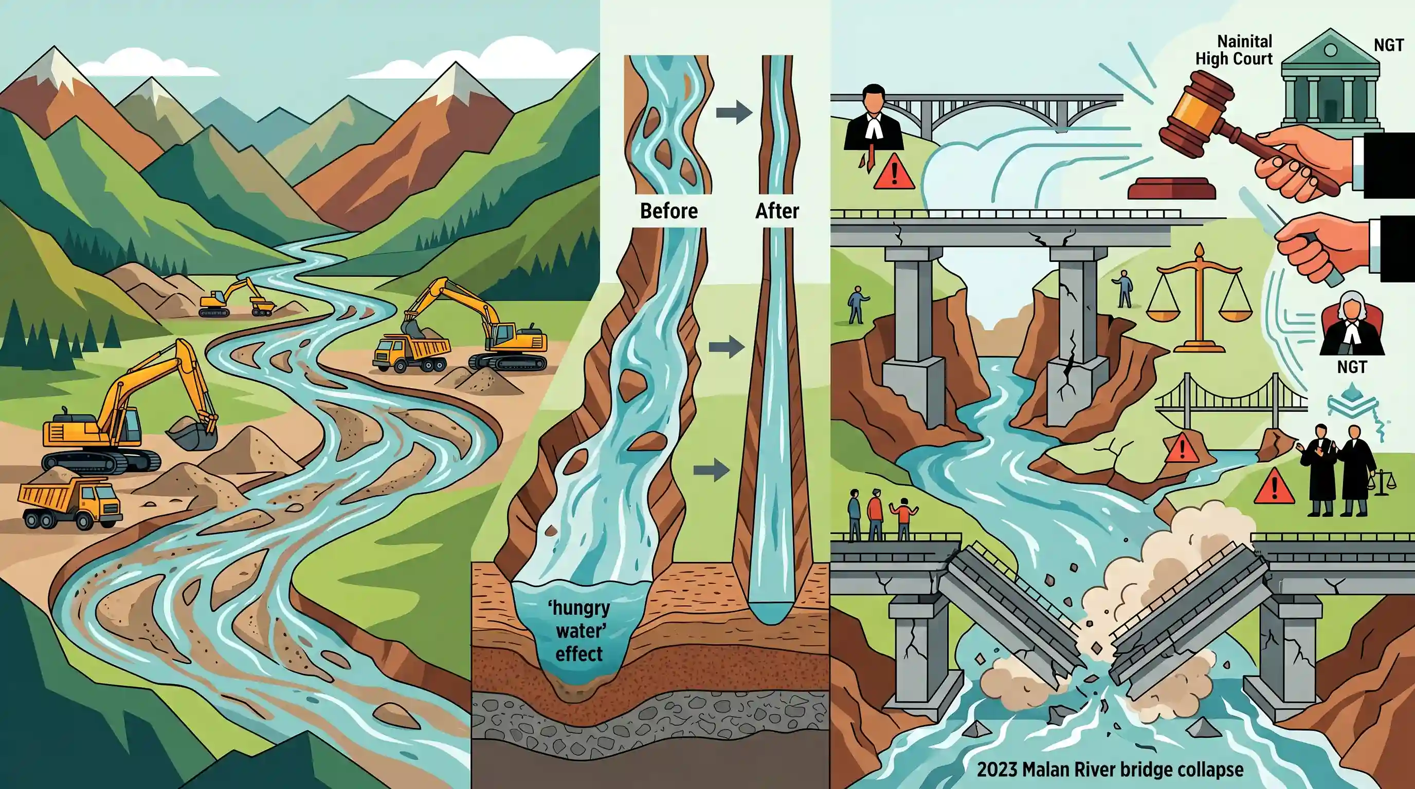
This article by SANDRP examines how unscientific and illegal riverbed sand mining in Uttarakhand and Himachal Pradesh is destabilizing river ecosystems and critical infrastructure. Citing scientific studies, including research by IIT Kanpur on the Upper Ganga and another on the Gaula River, it explains how excessive extraction triggers the 'hungry water' effect, leading to riverbed incision (deepening), channel narrowing, and the transformation of dynamic riverbeds into single-thread or 'underfit' channels. These geomorphic changes have undermined bridge foundations, leading to the collapse of the Malan River bridge in 2023 and threatening key bridges on the Yamuna and Giri rivers. The piece highlights the judicial interventions of the Nainital High Court and the NGT in addressing these environmental hazards.
Key Points
- Unscientific and illegal in-channel riverbed sand mining is emerging as a critical geomorphic and disaster risk driver across Uttarakhand and Himachal Pradesh.
- The 'Hungry Water Effect' occurs when sediment-starved rivers (due to excessive sand/gravel extraction) aggressively erode their beds and banks downstream to replenish their sediment load, causing structural damage and bank collapse.
- An October 2025 study by IIT Kanpur ('River Sand Mining: A Developing Geohazard in the Himalaya') revealed that mining along a 32-km stretch of the Upper Ganga has transformed complex braided channels into narrow, degraded, single-thread rivers.
- A February 2025 satellite-based study (1976-2021) of the Gaula River in Haldwani showed that sand mining has forced the wide, dynamic river into a narrowed, deepened 'underfit' channel, reducing geomorphic diversity.
- Severe infrastructure damage has resulted from mining near bridge pillars, violating local safe-distance norms. Key examples include the Malan River bridge collapse (July 2023) near Kotdwar, and ongoing risks to the Paonta bridge (Yamuna) and Bangran bridge (Giri) in Himachal Pradesh.
- In August 2023, the Nainital High Court directed the Uttarakhand state government to halt mining and submit restoration plans for bridges across the Malan, Sukhro, and Kho rivers following a public interest litigation.
Important Terms
National Green Tribunal (NGT)

A specialized statutory judicial body established under the National Green Tribunal Act, 2010, for the effective and expeditious disposal of cases concerning environmental protection, conservation, and resource degradation.
UPSC context
GS Paper 2: Statutory/quasi-judicial bodies; GS Paper 3: Environmental conservation and impact assessment.
South Asia Network on Dams, Rivers and People (SANDRP)
An informal network of organizations and individuals analyzing the developmental and environmental impacts of dams, hydropower projects, and unscientific riverbed mining across South Asian river basins.
UPSC context
GS Paper 3: Conservation, environmental pollution, degradation, and water resource management.
Uttarakhand Mining Policy 2022
A state policy governing minor mineral excavation (sand, gravel) designed to balance resource mobilization with environmental safeguards, repeatedly subjected to judicial reviews due to ecological hazards.
UPSC context
GS Paper 3: Resource planning, environmental impact assessment, and Himalayan ecology.
Nainital High Court
The Uttarakhand High Court, established in 2000, that has issued landmark judgments enforcing environmental regulations, checking illegal sand mining, and granting legal rights to rivers.
UPSC context
GS Paper 2: Judicial review and functioning of judiciaries; GS Paper 3: Ecological conservation.
IIT Kanpur
A premier institute leading scientific research on river systems and hosting the Centre for Ganga River Basin Management and Studies to assist environmental policy and restoration efforts.
UPSC context
GS Paper 3: Science, technology, and integrated water resources management.
Prelims Trap
The 'hungry water' phenomenon occurs when rivers carry excess sediment, leading to heavy deposition and rising riverbeds downstream.
The 'hungry water' effect is caused by a deficit (not excess) of sediment. The sediment-starved river uses its excess kinetic energy to aggressively erode its own bed and banks downstream.
Static Concepts Connected
What is the 'Hungry Water Effect' and how does it alter fluvial geomorphology?
- Definition: Occurs when sediment-starved water (due to upstream dams or excessive sand mining) retains high kinetic energy, aggressively eroding its bed and banks downstream to replenish its sediment load.
- Geomorphic Impact: Leads to channel incision (deepening), narrowing of dynamic braided channels into single-thread channels, and severe bank collapse.
- Infrastructure Hazard: Undermines civil engineering works by exposing and weakening bridge pier foundations and river training structures.
What are the distinctions between the Bhabar and Terai regions of the Himalayan foothills?
- Bhabar Belt: A porous tract of unassorted pebbles, gravel, and boulders where Himalayan rivers descend, causing surface streams to frequently disappear underground.
- Terai Belt: A swampy, marshy, and damp zone south of Bhabar where underground streams re-emerge to flow on the surface.
- Eco-hydrological Vulnerability: Unscientific mining in these highly porous zones disrupts groundwater tables and accelerates aquifer depletion in downstream plains.
Cross-Topic Patterns
Fluvial Geomorphology + Infrastructure DRR
Links dynamic riverbed changes (incision, hungry water) to infrastructure failure (bridge collapses), shifting disaster management from mere response to proactive geomorphic sediment-budget monitoring.
Giri River Geography + Tribal Demands
The Giri River's Trans-Giri region is central to the Scheduled Tribe (ST) status demands of the Hattee community, merging physical geography with federal polity.

Fluvial geomorphology (hungry water, channel incision) paired with Himalayan tributary origins (Giri, Gaula) likely for Prelims 2026.
Linked PYQs · 4
Linked PYQs · 4
- 2025UKPSC_PRELIMSGS1
Which of the following is the correct order of rivers from west to east in Uttarakhand?
- 2024UKPSC_PRELIMSGS1
Select the correct pair of the river basins separated by Dudhatoli Mt. Range.
- 2007UKPSC_PRELIMSGS1
Which of the following Natural Calamity has the most devastating impact in Uttarakhand State?
- 2025UKPSC_PRELIMSGS1
Consider the following statements and select the correct answer from the options given below : Statement 1 : Uttarakhand is highly vulnerable to climate change. Statement 2 : Climate change is causing water stress and depleting biodiversity in Uttarakhand.
