Meteorological Factors Behind Deficit Rainfall in June 2026
Source:Indian Express ↗
Why It Matters
The monsoon's performance dictates India's agricultural output, food inflation, and water security. Understanding the interplay of micro and macro climatic factors (like MJO, El Nino, and cyclogenesis) is vital for disaster preparedness and economic planning.
Summary
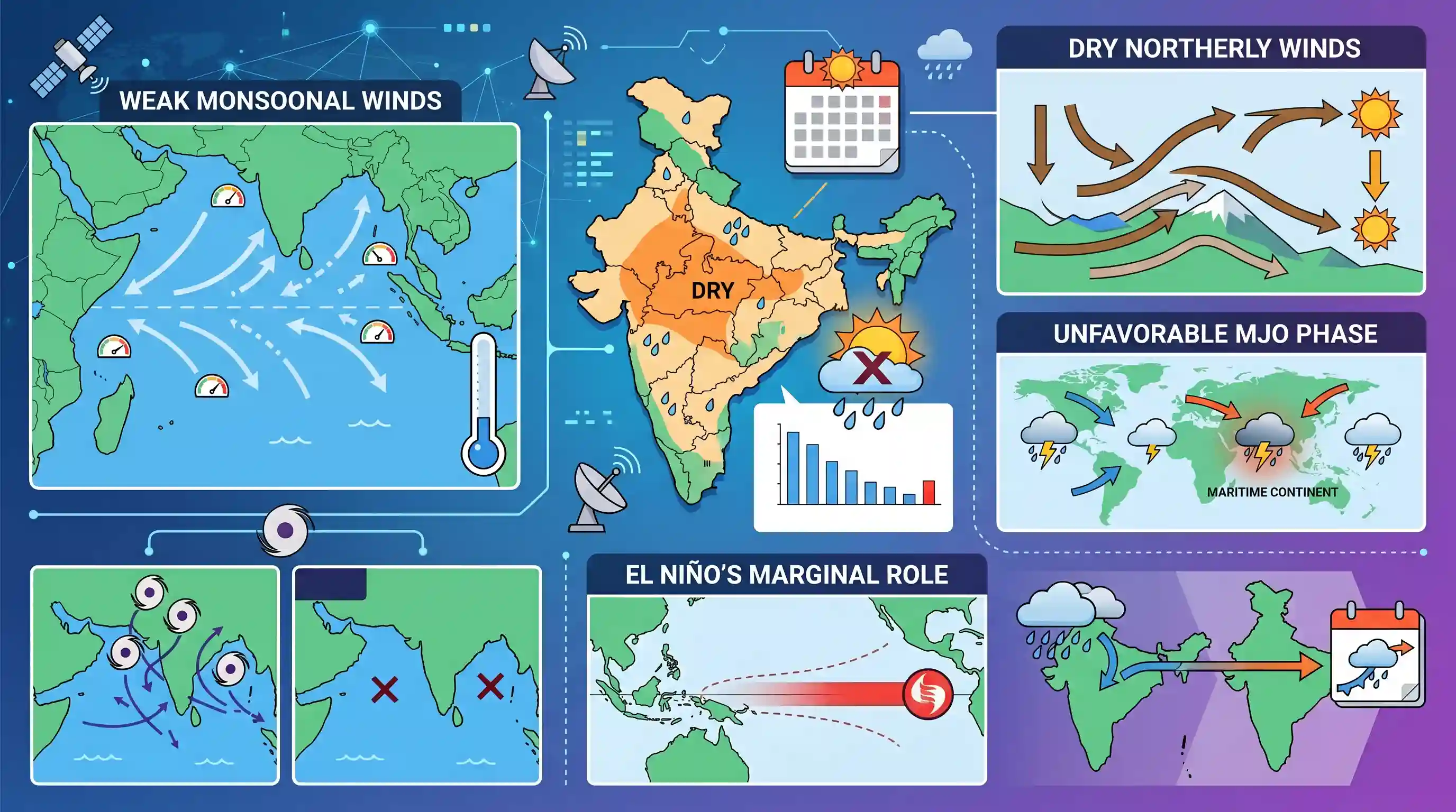
June 2026 is set to be the fifth driest June in India's recorded meteorological history since 1901, primarily due to weak monsoonal winds and a 43% rainfall deficit. The India Meteorological Department attributes this subdued performance to a combination of factors: an unfavorable phase of the Madden Julian Oscillation (MJO), the dominance of dry northerly winds, and the notable absence of pre-monsoon cyclones in the North Indian Ocean basin. Although El Niño—a common factor in historical monsoon failures—is present, its immediate role in suppressing June rainfall was marginal. The monsoon is expected to finally advance over north India by early July.
Key Points
- June 2026 recorded a 43% rainfall deficit, making it the fifth driest June in India since 1901.
- While previous abnormally dry Junes (1926, 2009, 2014) were linked to El Niño, its direct impact on June 2026 was marginal, with broader effects expected later in the season.
- An unfavorable phase of the Madden Julian Oscillation (MJO) allowed dry northerly winds to block the advance of weak monsoonal winds.
- The complete absence of pre-monsoon cyclonic storms in the North Indian Ocean basin deprived the monsoon of the initial momentum typically provided by these low-pressure systems.
Important Terms
India Meteorological Department (IMD)

Established in 1875, IMD is India's principal agency under the Ministry of Earth Sciences responsible for meteorological observations, weather forecasting, and seismology.
UPSC context
GS Paper 1/3; tests knowledge of India's institutional framework for weather monitoring and disaster management.
Madden Julian Oscillation (MJO)
An eastward-moving tropical disturbance of clouds, rainfall, and winds that circumnavigates the globe every 30-60 days, influencing monsoon 'active' and 'break' spells.
UPSC context
GS Paper 1 (Geography); critical for understanding intra-seasonal variability and short-term monsoon fluctuations.
El Niño
The warm phase of the El Niño-Southern Oscillation (ENSO), characterized by unusual warming of central and eastern Pacific waters, often weakening the Indian monsoon.
UPSC context
GS Paper 1; essential for explaining inter-annual monsoon failure and impacts on Indian agriculture.
Long Period Average (LPA)
The benchmark used by IMD to categorize rainfall, calculated as the average annual rainfall over a 50-year period (currently 1971–2020).
UPSC context
GS Paper 1/3; tests technical understanding of how 'normal' or 'deficient' monsoon seasons are defined.
Pre-monsoon cyclones
Tropical storms forming in the North Indian Ocean during April-May that can accelerate or disrupt the advance of monsoonal winds.
UPSC context
GS Paper 1 (Physical Geography); relates to seasonal transitions and cyclogenesis impacts on moisture transport.
Monsoon Deficit
A condition where seasonal rainfall is less than 90% of the Long Period Average (LPA) at the national scale, often triggering drought concerns.
UPSC context
GS Paper 3 (Economy/Environment); linked to food security, crop yields, and water resource management.
Prelims Trap
"The Madden-Julian Oscillation (MJO) is a stationary climate pattern anchored in the Indian Ocean."
MJO is not a stationary temperature anomaly like El Niño or IOD. It is an eastward-moving, 30-60 day traversing wave of wind and clouds that continuously circles the global equator.
Static Concepts Connected
How does the Madden-Julian Oscillation (MJO) differ from El Niño and IOD?
- Traversing wave: MJO is an eastward-moving equatorial weather cycle (30-60 days), unlike El Niño and IOD which are stationary oceanic temperature anomalies anchored in specific regions.
- Convective phases: Its enhanced convective phase brings heavy rainfall, while its suppressed phase brings dry, descending air that can block or delay monsoon winds.
What role do pre-monsoon cyclones play in the Indian summer monsoon?
- Trough advancement: Cyclonic low-pressure systems over the Arabian Sea or Bay of Bengal help pull the monsoon trough forward over the Indian subcontinent.
- Initial momentum: The anticlockwise circulation of these storms provides the critical initial thrust needed to pull moist southwesterly winds inland, establishing the monsoon.
Cross-Topic Patterns
Deficient monsoon and CPI inflation
A 43% June rainfall deficit delays Kharif sowing (rice, pulses). This supply-side shock feeds directly into food inflation, complicating the RBI's monetary policy and inflation targeting mandates.
Climate volatility and monsoon onset
While overall Arabian Sea warming generally increases cyclogenesis, anomalous years with zero pre-monsoon storms disrupt the traditional momentum needed for monsoon onset, reflecting increased climate-driven unpredictability.

Expect a Prelims question differentiating traversing MJO dynamics from stationary IOD/El Niño patterns affecting the Indian monsoon.
Linked PYQs · 3
Linked PYQs · 3
- 2014MainsGS1
Most of the unusual climatic happenings are explained as an outcome of the El-Nino effect. Do you agree?
- 2017PrelimsGS1
With reference to 'Indian Ocean Dipole (IOD)' sometimes mentioned in the news while forecasting Indian monsoon, which of the following statements is/are correct? 1. IOD phenomenon is characterised by a difference in sea surface temperature between tropical Western Indian Ocean and tropical Eastern Pacific Ocean. 2. An IOD phenomenon can influence an El Nino's impact on the monsoon. Select the correct answer using the code given below:
- 2014PrelimsGS1
The seasonal reversal of winds is the typical characteristic of
