Sutlej basin artificial lake floods threaten Kinnaur district villages
Source:sandrp ↗
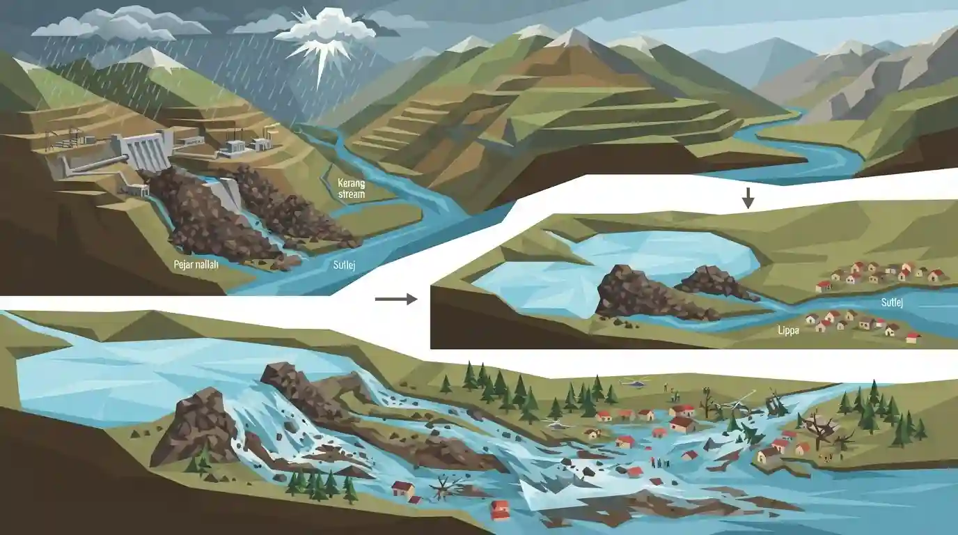
Why It Matters
The recurrent floods in Kinnaur present a classic case study of human-induced disasters in ecologically fragile areas, where developmental projects like hydropower (muck dumping) combine with extreme weather (cloudbursts) to endanger local communities. Crucial for understanding Himachal's disaster vulnerability and environmental geography.
Summary
The article highlights the recurring environmental disaster at Lippa village in Himachal Pradesh's Kinnaur district, where heavy rainfall and cloudbursts repeatedly cause flash floods and the formation of artificial lakes. Located in the Sutlej basin, the Pejar nallah and Kerang stream are heavily impacted by reckless muck disposal from the Integrated Kashang Hydroelectric Project operated by HPPCL. This muck blocks the natural river flow during heavy rains, creating artificial lakes that eventually burst, threatening downstream settlements. The situation underscores the severe ecological vulnerability of the Himalayan region and the disastrous consequences of poorly managed hydropower projects.
Key Points
- Lippa village in Kinnaur district faces recurrent flash floods and artificial lake formation along the Pejar nallah and Kerang stream in the Sutlej basin.
- These disasters are triggered by heavy rainfall and cloudburst events, which are becoming more frequent in the Himalayas.
- The impact is severely exacerbated by improper muck disposal from the Integrated Kashang Hydroelectric Project developed by HPPCL, which blocks river flow.
- The situation highlights the acute vulnerability of Kinnaur's fragile geology to unregulated hydropower development and extreme weather events.
Important Terms
SANDRP (South Asia Network on Dams, Rivers and People)

An informal network of organizations and individuals analyzing water sector policies, focusing on large dams, river conservation, and democratic water management in South Asia.
UPSC context
GS Paper III (Environment & Disaster Management); tests civil society oversight, environmental impact assessments, and river conservation.
HPPCL (Himachal Pradesh Power Corporation Limited)
A state government-owned enterprise responsible for planning, promoting, and executing hydroelectric power projects and transmission systems within Himachal Pradesh.
UPSC context
GS Paper III (Infrastructure & Energy); tests state public sector undertakings and the balance between development and environment.
Integrated Kashang Hydroelectric Project
A 243 MW run-of-the-river power project on the Kashang and Kerang rivers in Himachal Pradesh, facing intense local opposition due to ecological and tribal rights violations.
UPSC context
GS Paper III (Infrastructure & Environment); tests environmental impacts of large-scale run-of-the-river projects in fragile regions.
Sutlej Basin
The geographical drainage basin of the Sutlej River, a major tributary of the Indus system, which is crucial for northern India's hydrology and hydropower.
UPSC context
GS Paper I (Indian Geography); tests drainage patterns, Himalayan river systems, and geographical vulnerabilities in mountainous terrains.
Chilgoza Pine (Pinus gerardiana)
An endangered pine species native to the northwestern Himalayas, producing highly valued edible nuts and uniquely adapted to cold desert climates in tribal belts.
UPSC context
GS Paper III (Biodiversity); tests Himalayan endemic flora, conservation status, and ecological threats from development.
Gram Sabha Consent
Under Schedule V of the Constitution and the PESA Act, the mandatory local assembly approval required before diverting community forest land for developmental projects.
UPSC context
GS Paper II (Polity - Tribal Rights); tests scheduled areas, decentralized environmental decision-making, and constitutional safeguards.
Prelims Trap
"Run-of-the-river (RoR) hydroelectric projects are ecologically benign as they do not generate excavated muck."
While RoR projects lack large reservoirs, they require massive underground tunneling and headrace construction, generating huge quantities of muck that often block natural streams.
Static Concepts Connected
What are the key geographical features of the Sutlej River system?
- Antecedent Origin: Originates at Rakshastal (Tibet) and cuts deeply across the Greater Himalayas, making it a classic antecedent river.
- Entry into India: Enters Himachal Pradesh at the Shipki La pass in the Kinnaur district.
- Key Tributaries: Major right and left-bank tributaries include Spiti, Baspa, Kashang, Kerang, Wanger, and Tirung.
How does PESA intersect with infrastructure projects in Kinnaur?
- Fifth Schedule Status: Kinnaur is a designated Fifth Schedule area, bringing it under the purview of the PESA Act, 1996.
- Gram Sabha Consent: PESA mandates prior consultation with the local Gram Sabha before acquiring land or resettling populations for development projects.
- Minor Forest Produce: Empowers locals with ownership of Minor Forest Produce (MFP), crucial for protecting economic livelihoods dependent on the endangered Chilgoza pine.
Cross-Topic Patterns
RoR Projects & Himalayan Disasters
Links the muck-dumping disasters in Kinnaur (Sutlej) to similar catastrophic RoR project failures in Sikkim (Teesta) and Uttarakhand (Rishiganga), highlighting systemic vulnerabilities in Himalayan infrastructure.
Endemic Flora vs. Infrastructure
The destruction of Kinnaur's fragile slopes directly threatens India's largest naturally occurring Chilgoza pine forests, a rare Minor Forest Produce protected under PESA.

Expect a 2026 multi-statement question combining Sutlej tributaries (Kerang, Baspa) with PESA consent rules for RoR hydro-projects.
Linked PYQs · 3
Linked PYQs · 3
- 2020HPAS_PRELIMSGS1
Consider the given four statements and choose the correct answer from the given options. Select the true statements from the following: 1. Chamba, Kullu and Kinnaur are considered the most susceptible of landslide threat. 2. Una, Bilaspur, Sirmaur, Shimla and Solan are considered as low vulnerable of disaster threats. 3. Hum valley of Una district has hardly any natural drinking water source. 4. As per the study of central water board, Kala Amb valley in Sirmaur district has exploited the least underground water.
- 2024HPAS_PRELIMSGS1
Match List I with List II : | List I (Ramsar Site) | List II (Name of State) | |---|---| | (a) Rudrasagar lake | (i) Punjab | | (b) Harike lake | (ii) Assam | | (c) Deepor Beel lake | (iii) Tripura | | (d) Vembanand wetland | (iv) Kerala | Choose the correct answer from the options given below : Code: (a) (b) (c) (d)
- 2022HPAS_PRELIMSGS1
Zojila pass is located in :
