Sainj Valley faces downstream flood risks from landslide-dammed lake
Source:sandrp ↗
Why It Matters
The vulnerability of Himachal Pradesh's river valleys to cloudbursts and landslide-dammed lakes is a recurring theme in state exams. This incident highlights critical linkages between physical geography (Beas-Parvati river system), climate vulnerability, disaster response (SDRF), and energy infrastructure risks.
Summary
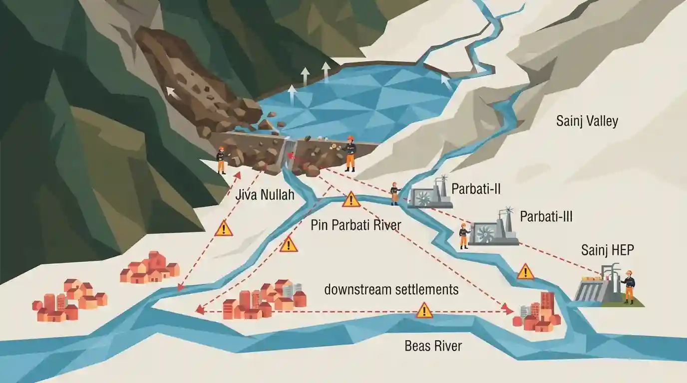
An expanding landslide-dammed lake on Jiva Nullah in Himachal Pradesh's Sainj Valley (Kullu district) has triggered serious flood warnings for July 2026. The Jiva Nullah is a key tributary of the Pin Parbati River (Beas Basin). The potential outburst threat (LLOF) poses severe risks to downstream settlements and over 1,500 MW of critical hydropower infrastructure, including NHPC's Parbati-II & Parbati-III and HPPCL's Sainj HEP, forcing inspections by the State Disaster Response Force (SDRF).
Key Points
- An artificial landslide lake on Jiva Nullah near Niri village (Sainj Valley, Kullu), formed in July 2023, has expanded significantly in July 2026 due to fresh monsoon-triggered landslides and debris accumulation.
- Jiva Nullah is a major tributary of the Pin Parbati River, which flows into the Beas River. Varshanu Nullah joins Jiva stream just downstream of Niri village.
- Over 1,500 MW of downstream hydropower infrastructure is at risk, including NHPC's Parbati-II (800 MW) and Parbati-III (520 MW) projects, HPPCL's Sainj HEP (100 MW), the Larji HEP (126 MW), and the 1 MW Jiva Small HEP.
- The area has a history of high vulnerability, marked by a massive cloudburst on June 25, 2025, in the Jiva/Varshanu catchments, which caused loss of lives, severe infrastructural damage, and high sedimentation of reservoir basins.
- The State Disaster Response Force (SDRF) dispatched a 12-member team in late July 2026 to assess the blockage and landslide-dam stability to advise the Kullu district administration.
- Experts emphasize the need for integrated disaster mitigation, including slope protection, catchment stabilization, and regular reservoir sediment management, to prevent catastrophic Landslide Lake Outburst Floods (LLOFs).
Important Terms
Landslide Lake Outburst Floods (LLOF)

A catastrophic flood occurring when a natural dam, created by a landslide blocking a river, breaches and suddenly releases massive volumes of trapped water downstream.
UPSC context
Crucial for GS Papers 1 & 3 (Geography and Disaster Management); highlights the Himalayas' vulnerability to hydro-meteorological hazards.
State Disaster Response Force (SDRF)
A specialized state-level emergency response force established under the Disaster Management Act, 2005, to act as the primary responders for rescue and relief operations during state disasters.
UPSC context
Important for GS Paper 3 (Disaster Management); tests knowledge of India's multi-tiered disaster management framework and federal responsibilities.
National Hydroelectric Power Corporation (NHPC)
India's largest hydropower development company and a Navratna Central Public Sector Enterprise under the Ministry of Power, responsible for planning and executing hydroelectric projects.
UPSC context
GS Paper 3 (Infrastructure/Energy). Tests understanding of India's renewable energy transition, critical infrastructure protection, and the role of CPSEs.
Himachal Pradesh Power Corporation Limited (HPPCL)
A state-owned enterprise incorporated in 2006 to plan, promote, and organize power generation in Himachal Pradesh, responsible for developing run-of-the-river projects like the Sainj HEP.
UPSC context
GS Paper 3 (Infrastructure); serves as a case study for state-driven clean energy generation and sustainable development in eco-sensitive zones.
Prelims Trap
LLOFs and GLOFs share identical trigger mechanisms, both requiring glacier retreat and moraine failure to initiate flooding downstream.
GLOFs are triggered by the failure of glacial moraine or ice dams, whereas LLOFs are caused by landslide debris blocking a river channel, which can occur in non-glaciated steep terrains.
Static Concepts Connected
What are the drainage and tributary characteristics of the Beas River system?
- Source: Originates at Beas Kund near Rohtang Pass on the southern end of the Pir Panjal Range in Himachal Pradesh.
- Tributaries: Major left-bank tributaries include the Parbati, Sainj, and Tirthan rivers, which carve deep gorges in the Kullu district.
- Confluence: Meets the Sutlej River at Harike Wetland in Punjab, India.
How do Run-of-the-River (RoR) projects operate and what are their vulnerabilities?
- Mechanism: Utilize the natural flow and elevation drop of a river with minimal or no water storage/pondage.
- Vulnerability: Highly vulnerable to upstream landslides, extreme siltation, and LLOFs/GLOFs due to the lack of massive protective reservoirs.
- Environmental Impact: Cause significantly less land submergence and displacement compared to conventional large storage-reservoir dams.
Cross-Topic Patterns
Hydro-development vs Himalayan fragile geology
Balancing clean energy targets with geological fragility in the Himalayas, highlighting the conflict between massive hydro infrastructure and active mass-wasting zones.
Disaster Risk Reduction and Sendai Framework
Using real-time monitoring and landslide dam assessments aligns with Sendai Framework Priority 4 (enhancing disaster preparedness) and National Disaster Management Authority (NDMA) guidelines on mountain hazards.

UPSC may test the physical geography of the Beas basin by linking its tributaries to landslide and LLOF hazard vulnerability in 2026.
Linked PYQs · 1
Linked PYQs · 1
- 2022HPAS_PRELIMSGS1
Select the incorrect combination from the following : (i) Bahadurpur and Bandla ranges : Demi valley (ii) Markanda and Dharti ranges : Dun and Sproon valleys (iii) Chandertal lake : Kunzam range (iv) Source of Parvati river : Mantilai lake
