Japan Issues Tsunami Advisory Following Strong Offshore Earthquake
Source:The Hindu ↗
Why It Matters
This event is a classic geographical case study for UPSC aspirants to understand the mechanisms of earthquakes and tsunamis, particularly in the Pacific Ring of Fire. It also serves as a practical example for Disaster Management (GS3), showcasing the importance of early warning systems and swift institutional response.
Summary
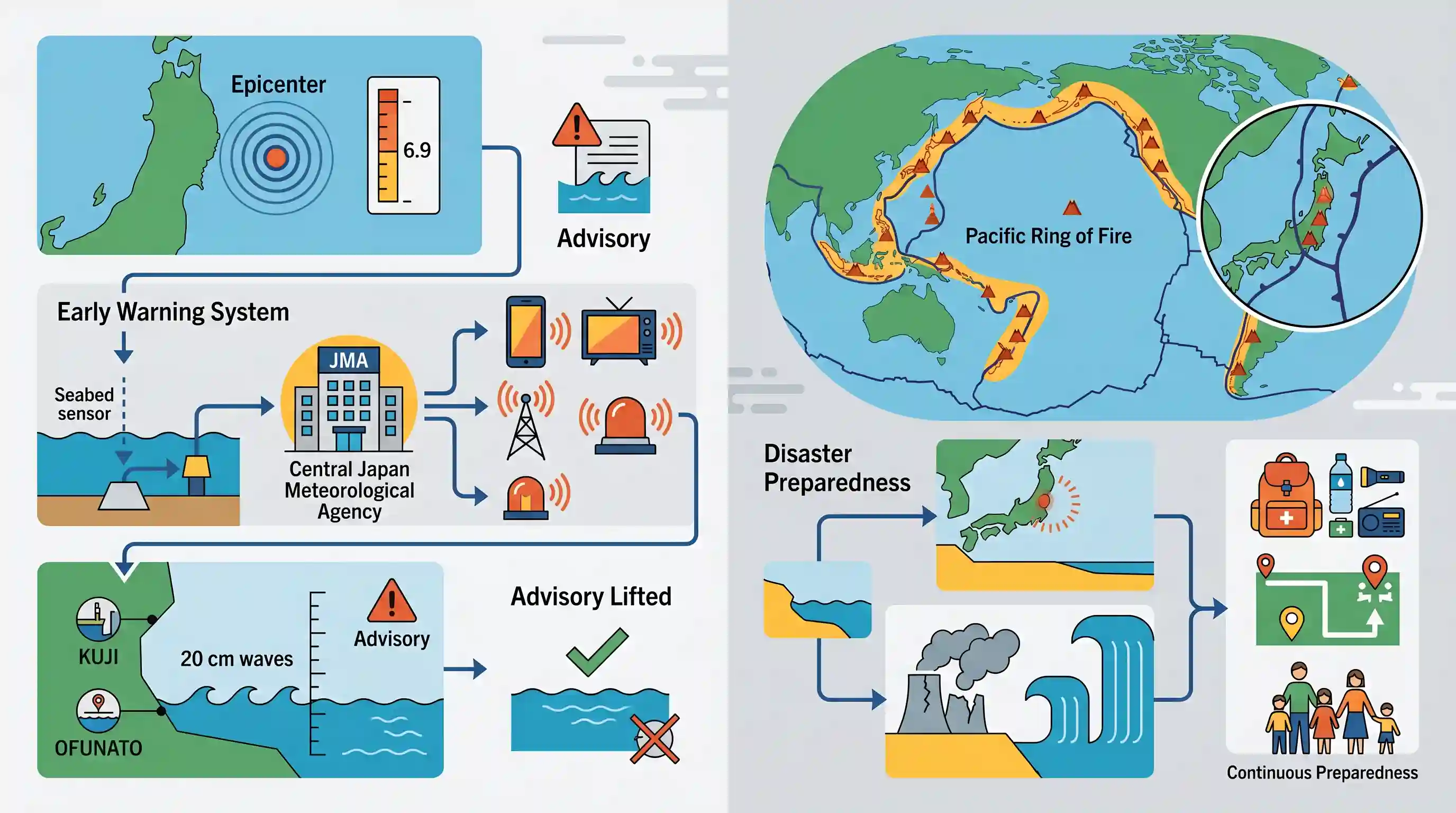
A 6.9-magnitude earthquake struck off the coast of northern Japan, generating a minor tsunami with waves up to 20 cm in ports like Kuji and Ofunato. The Japan Meteorological Agency quickly issued and then lifted a tsunami advisory, reporting no significant damage or injuries. The event serves as a stark reminder of Japan's vulnerability to seismic hazards due to its location on the Pacific 'Ring of Fire'. It also recalls the catastrophic 2011 earthquake and Fukushima nuclear disaster, emphasizing the critical importance of robust early warning systems and continuous disaster preparedness.
Key Points
- A 6.9-magnitude earthquake off the coast of northern Japan triggered a minor tsunami with waves reaching up to 20 cm in the Iwate region.
- The Japan Meteorological Agency (JMA) issued and swiftly lifted a tsunami advisory, with no reports of major damage or casualties.
- Japan's location on the Pacific 'Ring of Fire' makes it highly susceptible to frequent earthquakes and volcanic activity.
- The region was previously devastated by the 2011 9.0-magnitude earthquake and tsunami, which led to the Fukushima nuclear disaster.
- The incident highlights the effectiveness of Japan's early warning systems and the ongoing need for rigorous disaster preparedness.
Important Terms
Pacific Ring of Fire

A 40,000 km horseshoe-shaped zone encircling the Pacific Ocean, characterized by intense volcanic activity and 90% of the world's earthquakes due to tectonic plate interactions.
UPSC context
GS Paper I (Geography). Vital for understanding global seismic belts, plate tectonics, and volcanic distribution.
Tsunami
A series of high-energy ocean waves caused by sudden water displacement from undersea earthquakes, landslides, or volcanic eruptions, capable of traveling at jet-plane speeds.
UPSC context
GS Paper I & III. Core topic for geomorphology and coastal disaster management.
Early Warning System (EWS)
An integrated system of monitoring, forecasting, and communication that generates timely alerts to allow individuals and communities to take proactive measures before a disaster occurs.
UPSC context
GS Paper III (Disaster Management). Tests knowledge of technological interventions and Sendai Framework compliance.
Japan Meteorological Agency (JMA)
Japan's government agency responsible for weather, seismic, and tsunami monitoring; globally recognized for its advanced multi-hazard warning infrastructure like J-Alert.
UPSC context
GS Paper III. Important case study for international best practices in institutional disaster preparedness.
Sendai Framework for Disaster Risk Reduction
A 2015–2030 global agreement aiming for the substantial reduction of disaster risk and losses, emphasizing early warning systems and "Building Back Better."
UPSC context
GS Paper III. Key international policy framework for disaster risk governance and resilience.
Subduction Zone
Geological regions where one tectonic plate sinks beneath another into the mantle, often producing the world's most powerful, tsunamigenic earthquakes.
UPSC context
GS Paper I (Geography). Fundamental concept for understanding tectonic boundaries and seismic hazard zones.
Prelims Trap
Tsunamis are frequently generated by massive horizontal strike-slip earthquakes at oceanic transform boundaries.
Tsunamis require massive vertical displacement of the seafloor to move the water column. This occurs at convergent (subduction) zones, not via the horizontal movement typical of transform boundaries.
Static Concepts Connected
How do subduction zones trigger tsunamigenic earthquakes?
- Convergent boundaries: One tectonic plate subducts under another, accumulating immense friction and stress over centuries.
- Vertical snap: Sudden slip pushes the overriding plate upwards, vertically displacing massive volumes of ocean water.
- Wave amplification: Deep-ocean waves travel at jet speeds and dramatically increase in height (shoaling) upon reaching shallow coasts.
What is India's framework for tsunami early warning?
- INCOIS nodal role: The Indian National Centre for Ocean Information Services (INCOIS) operates the ITEWS for the Indian Ocean.
- Bottom Pressure Recorders: BPRs deployed on the seafloor measure the overlying water column's pressure to confirm tsunami wave generation.
Cross-Topic Patterns
Sendai Framework + Natech disasters
The 2011 Fukushima meltdown exemplifies a 'Natech' (Natural-Technological) disaster. This directly ties into Sendai Framework Target D (reducing disaster damage to critical infrastructure) and India's CDRI initiative.
Ring of Fire + Geothermal potential
The active subduction zones triggering these earthquakes also create immense geothermal gradients. UPSC often links tectonic boundaries to both geohazard vulnerability and renewable energy/mineral potential.

Natech disasters and INCOIS Bottom Pressure Recorders are prime candidates for a blended Geography/Disaster Management question in 2026.
Linked PYQs · 3
Linked PYQs · 3
- 2022PrelimsGS1
If a major solar storm (solar flare) reaches the Earth, which of the following are the possible effects on the Earth? 1. GPS and navigation systems could fail. 2. Tsunamis could occur at equatorial regions. 3. Power grids could be damaged. 4. Intense auroras could occur over much of the Earth. 5. Forest fires could take place over much of the planet. 6. Orbits of the satellites could be disturbed. 7. Shortwave radio communication of the aircraft flying over polar regions could be interrupted. Select the correct answer using the code given below:
- 2025MainsGS1
What are Tsunamis? How and where are they formed? What are their consequences? Explain with examples.
- 2024MainsGS3
What is disaster resilience? How is it determined? Describe various elements of a resilience framework. Also mention the global targets of Sendai Framework for Disaster Risk Reduction (2015–2030).
