Emergency-era treaties led to fishermens issues: Jaishankar
Source:Indian Express ↗
Why It Matters
The Katchatheevu dispute is highly relevant for GS2 (International Relations) as it exemplifies how historical treaties impact current bilateral ties and domestic politics. It is a classic case study on maritime border issues, traditional fishing rights, and India's neighborhood policy.
Summary
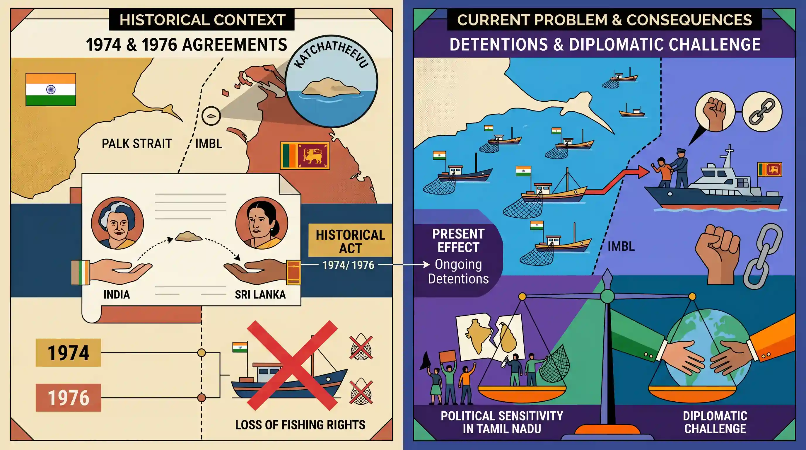
External Affairs Minister S. Jaishankar has attributed the ongoing detentions of Indian fishermen by Sri Lankan authorities to historical maritime boundary agreements signed by the Indira Gandhi government during the Emergency. In 1974, India officially recognized Sri Lanka's sovereignty over Katchatheevu Island, and a subsequent 1976 treaty barred Indian fishermen from operating in the island's adjacent waters. The loss of these traditional fishing rights across the International Maritime Boundary Line (IMBL) in the Palk Strait remains a politically sensitive issue in Tamil Nadu and a persistent diplomatic challenge in India-Sri Lanka relations.
Key Points
- External Affairs Minister S. Jaishankar linked the repeated arrests of Indian fishermen by the Sri Lankan Navy to maritime agreements signed during the 1975-77 Emergency under PM Indira Gandhi.
- Under the 1974 Indo-Sri Lankan Maritime Agreement, India recognized Katchatheevu Island as Sri Lankan territory.
- A subsequent 1976 agreement established the International Maritime Boundary Line (IMBL) and effectively relinquished the traditional fishing rights of Indian fishermen in the region's waters.
- The unresolved grievances over Katchatheevu remain a recurring friction point in India-Sri Lanka bilateral relations and continue to threaten the livelihoods of Tamil Nadu fishermen operating in the Palk Strait.
Important Terms
Katchatheevu Island

A 285-acre uninhabited island in the Palk Strait, ceded by India to Sri Lanka in 1974. It is central to disputes over traditional fishing rights and maritime sovereignty.
UPSC context
GS-II: India and its Neighborhood. Tests knowledge of territorial disputes and bilateral maritime treaties.
1974 Indo-Sri Lankan Maritime Agreement
A treaty between India and Sri Lanka that demarcated the maritime boundary in the Palk Strait, officially recognizing Sri Lankan sovereignty over Katchatheevu Island while granting Indian fishermen limited access.
UPSC context
GS-II: Bilateral Agreements. Crucial for understanding historical shifts in India's maritime policy and neighborhood relations.
1976 Maritime Boundary Agreement
A follow-up treaty that extended maritime boundaries in the Gulf of Mannar and Bay of Bengal, explicitly barring fishermen of either country from fishing in the other's Exclusive Economic Zone (EEZ).
UPSC context
GS-II: International Relations. Explains the legal basis for the current arrests of Indian fishermen by Sri Lanka.
International Maritime Boundary Line (IMBL)
The legal maritime border between India and Sri Lanka established by the 1974 and 1976 agreements, patrolled to prevent illegal fishing and unauthorized crossings.
UPSC context
GS-III: Internal Security. Relates to border management and maritime security challenges.
Palk Strait
A narrow strip of water separating the Tamil Nadu coast of India from the Jaffna region of Sri Lanka, serving as a primary site for fisherman-related diplomatic tensions.
UPSC context
GS-I: Geography. Important for mapping exercises and understanding the geostrategic significance of the Indian Ocean.
Wadge Bank
A fertile, 10,000 sq. km fishing ground near Kanyakumari over which India gained sovereign rights in 1976 as part of the maritime settlement with Sri Lanka.
UPSC context
GS-II: Bilateral Agreements. Represents a 'quid pro quo' in maritime diplomacy and resource management.
Prelims Trap
The transfer of Katchatheevu to Sri Lanka required a Constitutional Amendment Act under Article 368.
The 1974 transfer occurred via an executive agreement. The Centre argued Katchatheevu was 'disputed' territory, not established Indian territory, thereby bypassing the Berubari ruling requirement for an amendment.
Static Concepts Connected
What is the constitutional procedure to cede Indian territory to a foreign state?
- Constitutional Amendment: As ruled in the Berubari Union case (1960), ceding established Indian territory to a foreign state cannot be done by mere executive action.
- Article 368: Cession requires a formal Constitutional Amendment Act under Article 368 (e.g., the 100th CAA for Bangladesh enclaves).
- Boundary Dispute Exception: Settling a true 'boundary dispute' does not amount to ceding territory and can be done by executive action alone.
How are maritime boundaries resolved in narrow waters like the Palk Strait?
- Overlapping Zones: Under UNCLOS, when two coastal states are less than 24 (or 400) nautical miles apart, they cannot unilaterally claim full territorial seas or EEZs.
- Bilateral Treaties: Such boundaries are determined by bilateral treaties, often utilizing the median/equidistance line, as done in the 1974 and 1976 Indo-Sri Lankan maritime agreements.
Cross-Topic Patterns
Marine Ecology + Bilateral Disputes
The diplomatic standoff is compounded by 'bottom trawling'. Tamil Nadu fishermen's use of this ecologically destructive method depletes marine resources, prompting Sri Lanka's strict 2017 legislative ban and subsequent naval arrests.
Polity + Post-Independence Consolidation
The Katchatheevu transfer is heavily studied against the Berubari Union case and 100th CAA. The technical distinction between 'ceding territory' and 'settling boundary disputes' is a core Polity overlap.

Expect a 2026 Polity question contrasting the executive transfer of Katchatheevu with the 100th CAA (Bangladesh) regarding Article 368.
Linked PYQs · 2
Linked PYQs · 2
- 2022MainsGS2
India is an age-old friend of Sri Lanka.’ Discuss India's role in the recent crisis in Sri Lanka in the light of the preceding statement.
- 1996PrelimsGS1
The Palk Bay lies between
