India Rejects China Renaming Places in Arunachal
Source:The Hindu ↗
Why It Matters
China's 'cartographic aggression' (renaming places and establishing new administrative units in disputed territories like Arunachal Pradesh and Aksai Chin) presents a chronic diplomatic and security challenge for India. Understanding the interplay between border disputes, internal Chinese security concerns (ETIM in Xinjiang), and geopolitical projects (CPEC) is critical for UPSC aspirants analyzing India's foreign policy and border management strategies.
Summary
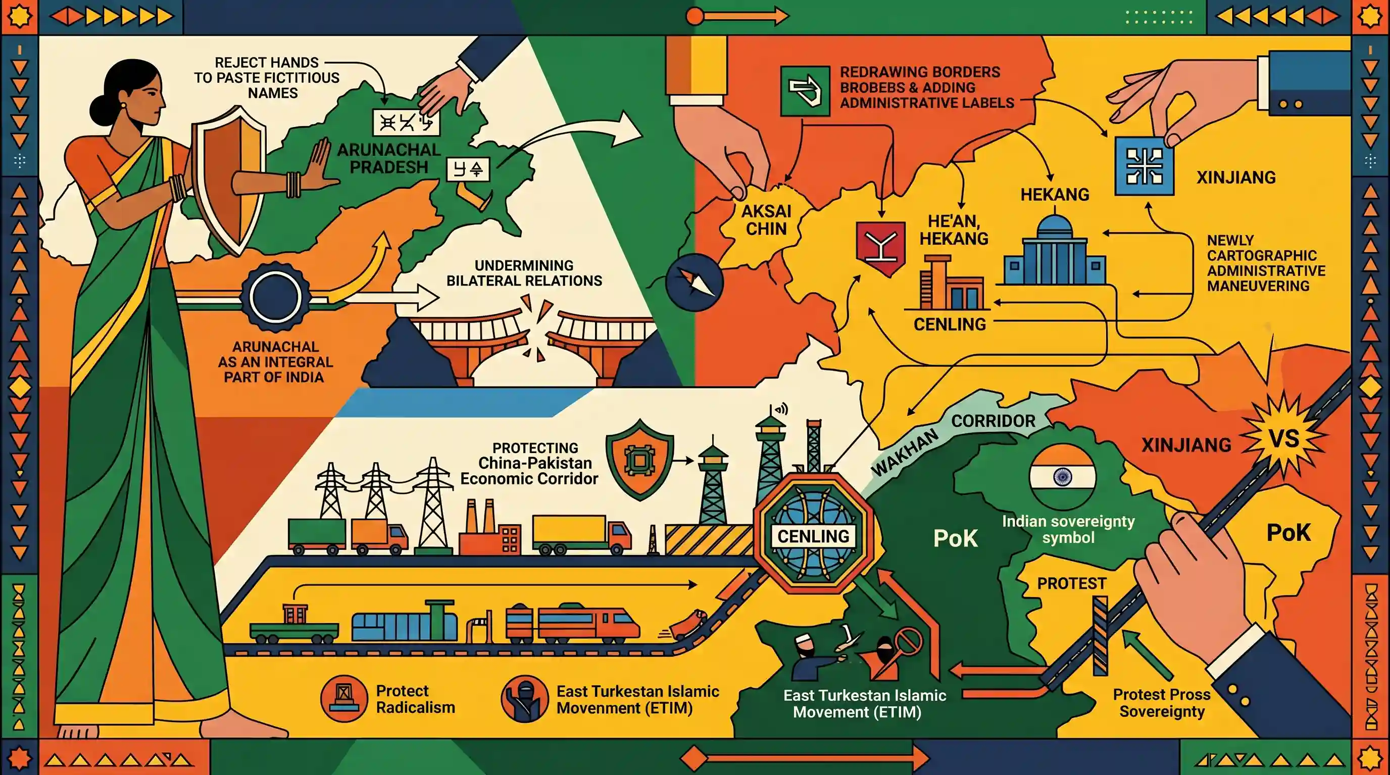
India has strongly rejected China's recent attempts to assign "fictitious names" to places in Arunachal Pradesh, with the Ministry of External Affairs asserting that the state remains an inalienable part of India. The MEA noted that such "mischievous" actions undermine efforts to normalise bilateral relations. Furthermore, the article highlights China's ongoing cartographic and administrative maneuvering along the frontiers. Following the creation of 'He'an' and 'Hekang' counties in the disputed Aksai Chin region last year, China has now created 'Cenling' county in Xinjiang. Located strategically near PoK and the Wakhan corridor, Cenling aims to curb the East Turkestan Islamic Movement (ETIM) and protect the China-Pakistan Economic Corridor (CPEC)—a project that India consistently protests for violating its sovereignty over PoK.
Key Points
- India officially rejected China's attempt to assign "fictitious names" to locations in Arunachal Pradesh, calling the moves mischievous and detrimental to the normalisation of bilateral ties.
- The Ministry of External Affairs (MEA) reiterated that Arunachal Pradesh is an integral and inalienable part of Indian territory, regardless of Chinese manufactured narratives.
- China recently established a new county named 'Cenling' in the Xinjiang province, situated near the Karakoram range, PoK, and Afghanistan's Wakhan corridor.
- The creation of Cenling aims to manage the security of Xinjiang against the East Turkestan Islamic Movement (ETIM) and secure the starting point of the China-Pakistan Economic Corridor (CPEC), a project India opposes due to sovereignty violations in PoK.
- This follows China's previous creation of 'He'an' and 'Hekang' counties in Hotan Prefecture, which controversially included parts of the Aksai Chin plateau falling within the Union Territory of Ladakh.
Important Terms
China-Pakistan Economic Corridor (CPEC)

A flagship project of China's Belt and Road Initiative (BRI) connecting Xinjiang to Pakistan’s Gwadar port. India opposes it as it passes through Pakistan-occupied Kashmir (PoK), violating Indian sovereignty.
UPSC context
GS-2: International Relations, India-China-Pakistan triad, and sovereignty issues over PoK.
Cartographic Aggression
The intentional misrepresentation of international boundaries on official maps or through naming conventions to assert illegal territorial claims and influence public perception.
UPSC context
GS-2: India-China border disputes and psychological warfare in foreign policy.
East Turkestan Islamic Movement (ETIM)
A militant separatist group founded by Uyghurs in Xinjiang seeking an independent "East Turkestan." It is designated a terrorist organization by the UN for its links to Al-Qaeda.
UPSC context
GS-3: Internal security and global terrorism; GS-2: China's internal security concerns.
Wakhan Corridor
A narrow panhandle of Afghan territory separating Tajikistan from Pakistan-administered territory. It provides the only direct land contact between Afghanistan and China, serving as a vital strategic buffer.
UPSC context
GS-2: Strategic geography and neighborhood relations in Central and South Asia.
Aksai Chin
A high-altitude disputed region in the Western Sector of the India-China border. Controlled by China as part of Xinjiang, it is claimed by India as part of Ladakh.
UPSC context
GS-2: Border management and history of the 1962 Sino-Indian conflict.
Ministry of External Affairs (MEA)
The central government agency responsible for managing India’s foreign relations, formulating diplomatic policy, and representing the nation’s official stance on territorial and international disputes.
UPSC context
GS-2: Institutional framework for foreign policy and diplomatic representation.
Prelims Trap
"The Wakhan Corridor is a narrow high-altitude territory linking Tajikistan directly to Pakistan."
The Wakhan Corridor is a narrow strip of Afghanistan, not Tajikistan or Pakistan. It acts as a buffer separating Tajikistan (north) from Pakistan-occupied Kashmir (south).
Static Concepts Connected
What is the geographic significance of the Wakhan Corridor?
- Buffer Zone: It is an Afghan panhandle separating Tajikistan in the north from Pakistan-occupied Kashmir (PoK) in the south.
- Sino-Afghan Link: It provides Afghanistan its only direct land border with China, connecting specifically to the Xinjiang province.
- Historical Context: It was deliberately created as a buffer zone during the 19th-century 'Great Game' between the British and Russian Empires.
How does India counter Chinese cartographic and border aggression?
- Infrastructure Push: India is aggressively expanding border infrastructure through BRO projects, such as the Sela Tunnel, ensuring all-weather troop mobility in Arunachal Pradesh.
- Demographic Stabilization: The Vibrant Villages Programme funds infrastructure and economic opportunities in northern border villages to prevent out-migration and assert demographic claims.
- Diplomatic Rejection: India consistently issues strong diplomatic rebuttals, rejecting "fictitious names" to maintain a clean legal standing on its sovereignty over Arunachal Pradesh and Aksai Chin.
Cross-Topic Patterns
Cartographic warfare + Vibrant Villages
China’s renaming strategy and creation of 'Xiaokang' (border defense) villages directly mirror India’s recent infrastructural push through the Vibrant Villages Programme to retain demographic presence along the LAC.
Uyghur militancy reshaping CPEC security
China's administrative restructuring in Xinjiang (Cenling county) highlights the vulnerability of the multi-billion dollar CPEC corridor to transnational militant groups like ETIM operating near the Wakhan/PoK axis.

Map-based geography questions linking the Wakhan Corridor, Aksai Chin, and CPEC entry points (Kashgar/Gilgit) are highly probable in 2026.
Linked PYQs · 4
Linked PYQs · 4
- 2024MainsGS3
India has a long and troubled border with China and Pakistan fraught with contentious issues. Examine the conflicting issues and security challenges along the border. Also give out the development being undertaken in these areas under the Border Area Development Programme (BADP) and Border Infrastructure and Management (BIM) Scheme.
- 2014MainsGS2
With respect to the South China sea, maritime territorial disputes and rising tension affirm the need for safeguarding maritime security to ensure freedom of navigation and over flight throughout the region. In this context, discuss the bilateral issues between India and China.
- 2016MainsGS3
Border management is a complex task due to difficult terrain and hostile relations with some countries. Elucidate the challenges and strategies for effective border management.
- 2012MainsGS2
Do you think that China's emergence as one of the largest trading partners of India has adversely affected the settlement of the outstanding border problem?
